
Several news sources featured in the Daily Digest may limit the number of articles you can access without a subscription. However, gift articles and open-access links are provided when available. For more open access California water news articles, explore the main page at MavensNotebook.com.
On the calendar today …
- STATE WATER BOARD WORKSHOP: Capturing Floodflows Without a Permit beginning at 10am. The workshop is meant for anyone who intends to divert surface water for groundwater recharge this winter. Scientists are observing intensified El Niño conditions in the equatorial Pacific, which could lead to increased winter precipitation with high-water storms in California. Registration link: https://waterboards.zoom.us/meeting/register/L7PqPju_SVqi_b2PqVECPw
In California water news today …
Healthy Rivers and Landscapes (aka Voluntary Agreements) on the rocks?
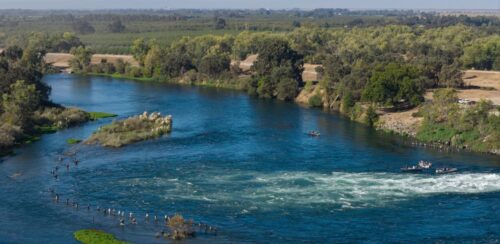
“With a vote looming at the end of October on a long overdue update to the rules governing flows through, and exports from, California’s major rivers and Delta, a program at the core of the plan is on shaky ground as key participants signal they may walk away. The 2026 update to the State Water Resources Board’s Water Quality Control Plan for the San Francisco Bay/Sacramento-San Joaquin Delta Watershed–the first major update to the statutorily required plan since 2006—is meant to protect beneficial uses of California’s water resources, including environmental protection and restoration. At the heart of the plan is the Healthy Rivers and Landscapes Program (also known as the Voluntary Agreements), which are designed as an alternative to minimum unimpaired flow requirements. Under the program, participating water users would agree to provide a certain amount of water over a specified baseline and undertake thousands of acres of habitat restoration throughout the watershed. Non-participating water users would continue to be subject to more stringent flow requirements. … ” Continue reading from Cariad Hayes Thronson on Maven’s Notebook.
El Niño then and now
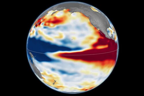 “El Niño is part of a natural climate pattern that occurs roughly every two to seven years, bringing warmer-than-normal water to parts of the equatorial Pacific. The most recent very strong El Niño events, in 1997-98 and 2015-16, upended weather patterns. Impacts spanned the planet, from fires in Indonesia and the Amazon, to crop failures due to drought in southern Africa, to heavy rain and coastal flooding in Southern California. The current El Niño rivals these past heavyweights. Every El Niño grows from a feedback loop between the atmosphere and the ocean. Trade winds normally keep warm water piled up in the western Pacific, where it stands higher than in the east. When those winds weaken, that warm water begins to pulse eastward, which further weakens and sometimes reverses the winds, allowing even more warm water to move east. The cycle intensifies as waters continue to warm and pile up in the central and eastern Pacific. But each El Niño has its own character, shaped by where in the Pacific the warmth builds and how the atmosphere responds. “The search for the ‘typical’ El Niño is very elusive,” said Josh Willis, project scientist for sea level missions at NASA’s Jet Propulsion Laboratory (JPL). “They’re all different in terms of where they land and how their impacts play out.” … ” Read more from NASA/JPL.
California has a plan for El Niño’s torrential rain: Save it for later
 “Something ominous just hit California: rain. The life-giving water that normally hydrates people and crops brings an aura of dread this autumn, thanks to the strongest El Niño ever recorded. While the phenomenon causes severe drought and heat in many parts of the world, historically it’s brought extraordinary rainfall to the Golden State. The monstrous El Niño of 1997 and 1998, for instance, caused widespread flooding and debris flows (made not just of water and dirt, but big chunks of rock), destroying property and killing residents. The state can’t stop rain from falling, so in the last few decades it has been renegotiating its relationship with precipitation. As climate change makes California whiplash from years of intense drought to years of intense rain, water agencies have been capturing as much H2O as they can to reduce reliance on using canals to bring it in from afar. That’s set the state up to avoid at least some flooding as this El Niño takes hold and bank the bounty for the dry spells to come. “Heavy storms can affect regional infrastructure, construction schedules, and areas vulnerable to debris flow or power disruptions,” said a spokesperson with the Los Angeles Department of Water and Power in a statement provided to Grist. “However, these rain events also present a significant opportunity. Stormwater capture is a critical pillar of LADWP’s long-term plan to reduce reliance on purchased imported water.” … ” Read more from Grist.
In California, a $40 water bill became $3,700 — and officials found 900 faulty meters
“Residents in Fowler, California, were left shocked and confused after receiving unreasonably high water bills. According to FOX26, city leaders said at a meeting that they had been receiving complaints about bills, with residents challenging whether the charges matched the water they had actually used. Mayor Juan Mejia said faulty antennas and meters that the city never got around to replacing appeared to be driving the billing issues. The problems occurred in roughly 900 meters, affecting both residents and commercial business customers. For example, Sophia Suarez’s water bill showed more than $3,700, but the Fresno County resident typically pays less than $40 a month. “So as you can tell, I almost had a heart attack,” Suarez said. … ” Read more from The Cool Down.
New DWR report highlights how collaboration strengthens climate resilience in water management
 As climate extremes become the new normal, DWR is using science, investments, and partnerships to strengthen readiness and protect Californians. Collaborating for Climate Resilience: The Power of Science and Partnerships is DWR’s contribution to California’s Fifth Climate Change Assessment. The report highlights how DWR advances science-driven decision-making through four focus areas: create a culture of climate expertise, build community capacity, pursue innovative infrastructure solutions, and respond to public safety emergencies. Together, these efforts improve the way water is managed throughout the state. Having a climate-literate workforce is essential as DWR tackles California’s growing climate challenges. By investing in employee development, advancing new technology, and collaborating with outside water management experts, DWR strengthens its ability to meet California’s climate goals. Staff across the department, including engineers, modelers, scientists, Tribal specialists, and others, apply climate knowledge to critical issues including flood management, groundwater sustainability, ecosystem resilience, regional assistance, and water supply. … ” Read more from DWR.
Just Transitions in the Delta: Drought, salinity and sea level rise – An invitation to the project’s final exhibition and public workshop
“Managing salinity in the Delta is a wicked problem. It’s far from any simple solution. It’s inseparable from many interacting phenomena and becoming more challenging with climate change impacts. And the definition of the problem varies across a diverse range of values and conflicting concerns (Luoma et al, 2015). How one understands and encounters Delta salinity depends on one’s experience and knowledge, as well as who one is – be it a fish, a clam, a scientist, a regulator, a city dweller, a recreational boater, or a Delta resident. When we asked a number of people if they thought planning and decision making for salinity management in the Delta is currently just or equitable, nearly 85% of respondents said they felt it was not. The term Just Transitions is utilized in the domains of climate, energy, and environmental justice and refers to efforts to reduce inequity in modern society and shift towards more sustainable economies, practices and lifeways. What might this be for the Delta and how its waters are managed? What might a just transition be? … ” Read more from the California Water Blog.
Voluntary agreements: yes or no?
As the State Water Board moves toward a vote on the Voluntary Agreements, known as the Healthy Rivers and Landscapes Program, Maven’s Notebook will publish commentaries this week examining the many sides of the proposal.
Restoring habitat, delivering results: The work already underway in the Sacramento Valley
Todd Manley, Director of Government Relations, Northern California Water, writes, “Every year, Chinook salmon return to the Sacramento Valley’s rivers, navigating upstream to the places where a new generation will begin. Along the way, they depend on adequate flows, connected waterways, and suitable spawning gravels to prepare nests for their eggs. Their young require cold water and places where they can find food and shelter while making their journey to the ocean. These are the building blocks of a healthy river system, and across the Sacramento Valley, people are working to restore them. On the American, Sacramento, Feather, Yuba and other waterways throughout the region, water managers, conservation organizations, scientists and state and federal agencies are putting years of planning into action. Spawning gravels are being replenished. Side channels are being reconnected. Floodplains are being restored to create productive habitat for young salmon. … ” Continue reading this commentary.
What the Pacific Flyway can teach us about water management
Jeff McCreary, Director of Operations, Western Region, Ducks Unlimited, writes, “Millions of ducks, geese, and other migratory birds travel the Pacific Flyway, one of North America’s most important migration routes, every winter. For eons, they used the Flyway’s wetlands, of which only vestiges remain. Today, they depend on a combination of California’s wetlands, wildlife refuges, rivers, and working agricultural lands for food, rest, and shelter. The Sacramento Valley plays an especially important role, providing critical wintering habitat for these birds. The abundance of waterfowl we see in the Sacramento Valley today is no accident. It is, in large part, the result of thoughtful water management and a remarkable conservation success story. Beginning in the early 1990s, rice growers increasingly turned to flooding their fields after harvest as an alternative to burning rice straw. What began as a change in agricultural practices also created expansive surrogate wetlands, providing nearly half of the food and habitat for migrating waterfowl. As winter flooding of rice expanded across the Sacramento Valley, the region experienced a dramatic shift in the distribution of wintering birds, with more ducks and geese concentrating in the valley. … ” Continue reading this commentary.
In regional water news and commentary today …
NORTH COAST
Humboldt County supervisors to consider moving Centerville Road inland
“After the California Coastal Commission approved a coastal development permit to allow the county to shore up issues along Centerville Road, the county appears to be looking at a different path. On Tuesday, the Humboldt County Board of Supervisors will be asked to consider whether the “proposed project to repair the Centerville Road storm damage site at the existing location is not in the public interest and not a prudent use of public funds,” the staff report for the meeting states. Instead of proceeding with what could be costly repairs — estimated by the county to exceed $4.8 million — the supervisors might consider shifting Centerville Road inland. “The cost for relocating the affected portion of Centerville Road to an inland location is unknown at this time, but is likely comparable or less than the cost of the storm damage repair project that was designed along the beach,” the staff report states. … ” Read more from the Eureka Times-Standard.
SIERRA NEVADA
Restoration is a messy work of art: Tuolumne River partners wrap up 2026 Powerhouse Riffle Restoration Project
“Nestled below Don Pedro Reservoir and supplying water to the Turlock and Modesto Irrigation Districts, lies the historic La Grange Diversion Dam on the Lower Tuolumne River. In a recent effort to improve habitat below the dam, Turlock Irrigation District (TID), Modesto Irrigation District (MID), and San Francisco Public Utilities Commission (SFPUC), in collaboration with local partners including FISHBIO, completed the 2026 Powerhouse Riffle Restoration project. The project restored 4.78 acres of riffle and gravel bar habitat that will support spawning fall-run Chinook salmon, recently observed spring-run Chinook salmon, rainbow trout, and juvenile rainbow trout rearing. During construction, heavy equipment pushed gravel in and out of the water, water became more turbid, and woody debris and flagging tape were strewn across the site. … ” Read more from FishBio.
NAPA/SONOMA
St. Helena’s citywide water pipe flushing starts Monday
“The city of St. Helena on Monday, Oct. 26, will launch an effort to comprehensively clean about 40 miles of water pipes throughout the city over the next two months using a “closed-loop” zero discharge flushing process that filters water and returns it into the system. That flushing effort — which will be carried by the city’s public works department and New Mexico-based contractor Hydrologics — is one prong of the city’s response to continued issues with discolored or brown water. The flushing is intended to remove decades of iron and manganese mineral buildup that city officials cite as a likely source of water discoloration. And it follows a June pilot program with Hydrologics that removed minerals from around seven miles of pipes. … ” Read more from the Santa Rosa Press Democrat.
BAY AREA
Marin reservoir drawdown planned as flooding defense
“The Marin Municipal Water District will lower the water level at its Phoenix Lake reservoir to lessen the likelihood of Ross Valley flooding this winter. “I’m happy to announce this evening that we, the county of Marin, are collaborating with Marin Water to again move water out of Phoenix Lake so it is free to capture runoff during early season rains and help reduce downstream flows,” Supervisor Brian Colbert said at a community meeting Monday at College of Marin in Kentfield. “Some of you may remember an October 2021 storm,” he said. “With the lake empty at the time it provided temporary storage during early-season atmospheric river events, which may have helped reduce flooding in Ross and downstream areas.” … ” Read more from the Marin Independent Journal.
Worrisome chemical found in Bay Area, Santa Cruz creeks
“Six years ago, scientists in the Pacific Northwest untangled a mystery about why salmon were dying in the region, often in astonishing numbers — with as many as 90% of the migrating adult coho salmon perishing in parts of Puget Sound. The culprit turned out to be a toxic chemical from tires washing into waterways. Now, some of the same researchers that made the 2020 discovery have confirmed that this tire-derived compound is present, at worrisome levels, in salmon-bearing watersheds in California. A study published last month in the journal Environmental Science and Technology Letters finds that at least 10 rivers and creeks in the Bay Area and Santa Cruz region have had potentially lethal concentrations of the chemical 6PPD-quinone after stormwater flowed into them. … ” Read more from the San Francisco Chronicle. | Read via Yahoo News.
River otters make comeback at Bay Area ranch for first time in over 100 years
“Ken Hickman has been photographing wildlife for years: burrow-dwelling kangaroo rats on the brink of extinction in the Santa Cruz Mountains, busy beavers building a dam in a reed-lined pond in San Luis Obispo, mountain lions wandering along trails in the South Bay. But when he recently reviewed footage captured by one of his cameras stationed in Cloverdale Ranch Open Space Preserve, the researcher couldn’t believe what he was seeing. It was a river otter. “Checking wildlife cameras can be like Christmas, but river otters haven’t been known to occur on the San Mateo Coast since the 1800s,” Hickman said in a news release from the Midpeninsula Open Space Trust earlier this month. “So I knew Midpen and State Parks biologists would be as surprised and interested as I was to see the photos.” … ” Read more from SF Gate.
Sunnyvale ahead on water conservation law
“Starting next year, a state law passed in 2023 will prohibit cities from using potable water on ornamental lawns. The law, AB1572, goes into effect in three stages — one at the start of 2027, one at the start of 2028 and the last starting at the beginning of 2029. Those stages correspond to who the law prohibits: cities, counties and other local agencies first, then, in 2028, commercial properties and finally homeowners associations. At the Oct. 6 Sunnyvale City Council meeting, Winola Cheong, deputy director of environmental services, detailed what the law meant for the city. The law only applies to ornamental lawns. Recreational lawns used for things such as golf courses, baseball fields or parks are exempt. To comply with the law, there are several options: water-wise gardens, drought-resistant landscaping, mulch or irrigating with recycled water through the city’s purple pipeline. … ” Read more from the Silicon Valley Voice.
San Jose rejects appeal of NVIDIA data center permit as environmental concerns persist
“A proposal to reclassify a research facility in North San Jose as a data center is moving forward, after the San Jose City Council rejected an appeal attempting to block the project on environmental grounds, amid a citywide backlash against data center developments. Councilmembers voted unanimously Tuesday — with Councilmember Peter Ortiz absent and Vice Mayor Pam Foley recused due to a financial conflict of interest — to quash the appeal from a coalition of labor groups and concerned residents. They sought to overturn city planners’ July 8 decision to approve a special use permit to operate a data center using up to 20 megawatts of power within an existing research and development building at 300 Holger Way. The permit would allow for interior improvements including the installation of data racks. … ” Read more from Local News Matters.
CENTRAL COAST
El Niño: Elkhorn Slough and other Northern California places most at risk this winter
“By now, most Northern Californians know that there are historically strong El Niño conditions in the Pacific Ocean which are increasing the chances for a rough and very wet winter. But some places face more risks than others. Low-lying coastal and bayfront areas — including Elkhorn Slough in Moss Landing, the beaches in Santa Cruz and the runways at San Francisco and Oakland airports — are particularly vulnerable to floods and damage this winter, according to a new report from UC Davis. Sea levels 2 to 3 feet higher than normal this winter due to El Niño conditions, on top of a high tide during a big storm, could flood roads, wreck piers and harbors, erode away beaches and damage homes in low-lying areas, along with putting wildlife habitat underwater, said Fraser Shilling, the author of the study and director of the Road Ecology Center at the UC Davis Institute of Transportation Studies. … ” Read more from the Monterey Herald.
SOUTHERN CALIFORNIA
Boeing’s demolition of a SoCal nuclear testing facility has nearby families worried about cancer
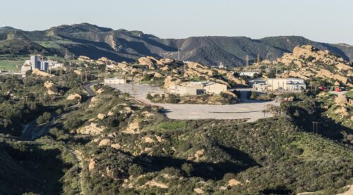 “Boeing has almost completed the demolition of five buildings at its infamous Santa Susana Field Laboratory in Southern California, even as concerns mount among nearby families about potential health harms. The buildings at the former Rocketdyne facility—where one of the worst nuclear meltdowns in U.S. history took place in 1959—were once used for Cold War-era nuclear energy research. Larry Yee, the former chair of the LA Regional Water Quality Control Board, on Wednesday called the site “a mini Chernobyl in our backyard.” Despite a groundswell of concerns about the process, the SSFL demolition at the lab between Simi Valley and Los Angeles began in late September. Four of the five buildings slated for demolition, all of which have sat unused for over 15 years, according to Boeing, have been brought down so far. The fifth demolition, at a site where more than 50 structures once stood, is slated to be completed this year. Among the already leveled structures is “Building 55,” known in its heyday as the Nuclear Materials Development Facility, which for decades was a storage, handling and processing facility for “unspent fuel rods,” explained local historian William Preston Bowling. “So they took fuel rods from all reactors from across the nation and took them to the Santa Susanna Field Laboratory and had them de-cladded and repurposed and shipped off for disposal at other sites,” Bowling said. … ” Read more from Inside Climate News.
A new talking point in LA County’s election season: Data centers
“The debate over data centers has found its way into Los Angeles County’s election season, where for months, even the mention of data center in public forums in some local cities has drawn keen attention in the run-up to November. In cities such as Alhambra and Monterey Park, the local fate of centers — the giant warehouses, built to power the nation’s artificial intelligence boom, and their kin, battery energy storage systems (BESS) — has manifested itself in ballot measures and candidate talking points, as towns debate whether such hubs should be built. In most cases, the centers don’t exist at all, and in a handful they’ve been proposed. But in L.A. County, like the rest of the nation, they’ve often become a symbol of pushback in a nation grappling with high costs and the relentless drive of technology companies seeking to build an AI infrastructure. … ” Read more from the LA Daily News.
SoCal coast expected to be under siege for days from extreme sea levels
“Near-record or record-high sea levels are expected to bring multiple days of flooding along the Southern California coast this week, with the inundation beginning as soon as Monday morning when high tide rolls in. Officials in Newport Beach and Long Beach have been scrambling to prepare as crews move sand to shore up beaches, install sandbags and otherwise work to protect areas, such as the Balboa Peninsula and the Long Beach Peninsula, hammered in recent month. Officials urged residents of flood-prone areas “to take precautions now,” including moving cars to higher ground and protecting property with sandbags. Seawater levels could reach near-record or record heights across Southern California, the National Weather Service warned. The highest high tides are expected on Monday, Tuesday and Wednesday mornings. … ” Read more from the LA Times. | Read via Yahoo News.
Long Beach braces for possible record high tides this week; coastal flood advisory in effect
“Parts of the Southern California coast will see possible record high tides, concerns are growing for beachfront homes on the Long Beach Peninsula, which has already been battered over the last few months. A coastal flood advisory went into effect Sunday morning as city crews continue to fortify sand berms in an effort to protect homes along the shoreline. Several homes have been red-tagged in recent weeks due to flooding and damage caused by high surf and high tide conditions. High tides between 7.5 and 8 feet are expected during the morning hours through Thursday over all coastal areas, according to the National Weather Service. Forecasters said Monday through Wednesday’s tides could challenge the current record of 7.93 feet set in San Pedro on Jan. 10, 2005. Records go back to 1924. … ” Read more from KABC.
A warmer Pacific Ocean is luring manta ray relatives to California’s coast
“On an unseasonably hot October day, a sightseeing catamaran skidded out of Dana Point Harbor and into the open sea. The sky was clear, offering postcard-pretty views of Catalina Island to the west, and the calm, 73-degree water was straight out of a bathtub. “It’s like a lake out here, which is wonderful conditions for sighting these animals,” Amanda McFadden, a naturalist for Captain Dave’s Dana Point Dolphin and Whale Watching Safari, announced to a few dozen passengers. By “these animals,” she was mostly talking about dolphins and whales, which are commonly sighted along this stretch of the Orange County coastline. But there was also a chance of spotting less common creatures that have lately made appearances up and down the Southern California coast due in part to El Niño’s warming effect. And one of those creatures was especially exciting: the devil ray. … ” Read more from SF Gate.
San Bernardino County partnership with Cadiz affiliate renews water pipeline fears
“San Bernardino County has partnered with a Cadiz Inc. affiliate to establish a public financing authority that could advance the company’s controversial Mojave Desert groundwater pipeline project, which has faced years of environmental opposition and litigation. The San Bernardino Water and Power Authority announced its formation Monday, Oct. 19, following an inaugural meeting on Oct. 5. The county Board of Supervisors unanimously approved the joint powers agreement with Fenner Gap Mutual Water Co., the Cadiz affiliate, on April 21. The partnership marks another potentially significant development for Cadiz, which has spent decades trying to bring its groundwater in the Cadiz and Fenner valleys, near Amboy, to Southern California communities despite fears that pumping could dry up natural springs and damage fragile desert ecosystems. … ” Read more from the San Bernardino Sun.
Along the Colorado River …
Southwest braces for more storms after enduring days of rain and flooding
“Another round of heavy showers and thunderstorms were expected to hit the south-west US on Sunday after the region endured days of rain that forced evacuations, water rescues and multimillion-dollar damage. The National Weather Service issued a flood watch for much of the Four Corners – the meeting point of Arizona, Colorado, New Mexico and Utah – even as local officials forecast further receding of swollen rivers that surged since rains picked up on Wednesday. About 4ft (1 meter) of water flooded the home of Shane Ferrari, the sheriff of San Juan county, New Mexico. He said the area’s situation was stable on Sunday, but he and other residents were trying to clean up and deal with damage. … ” Read more from The Guardian.
Interior secretary warns Arizona over Colorado River lawsuit
“Arizona’s historic legal fight over Colorado River water is drawing a warning from one of the Trump administration’s top officials, even as an Arizona congressman defends the state’s decision to take the federal government to court. U.S. Interior Secretary Doug Burgum cautioned that the lawsuit could backfire on a state already facing significant cuts to its Colorado River water supply. “The last thing that Arizona should want to do is have a judge decide where the water is going to go,” Burgum said during a visit to southern Arizona earlier this week. … ” Read more from Channel 15.
‘Cheap water is over’: A $500 bill shows a Southwest suburb’s dilemma
“Ron Rios treasures his backyard pool that makes Arizona’s triple-digit summer heat more tolerable. So he was furious to learn that his Phoenix suburb might hike his water bill: from $130 to, eventually, more than $500 a month. City leaders said it was necessary to fund sweeping investments that would secure their water supply for the next 100 years. The Colorado River was shrinking, they said, and they had to adapt. … Queen Creek, one of America’s fastest-growing cities, shows the challenges facing communities around the Southwest as the Colorado River dwindles and the remaining water gets more expensive. Rios uses an unusual amount of water, and his bill is an outlier. But it reflects a broader reality. Marc Skocypec, Queen Creek’s utility director, put it this way at a recent town meeting: “Cheap water is over.” … ” Read more from the Washington Post.
Heavy rain in southeast Utah has prompted a rise in Lake Powell’s water level. Here’s how much.
“Heavy rain that caused flooding last week in the Four Corners area of Utah, Colorado and New Mexico has had what water experts say is a beneficial side effect: A marked rise in the water level of Lake Powell. Saturday’s daily measurement of Lake Powell’s level was at 3,526.1 feet above sea level — which is 1.1 feet above the level the day before, and 7.1 feet above where the lake was two weeks ago, according to the Lake Powell Water Database. It’s also 9.5 feet above the lake’s lowest point on Sept. 15. “That’s phenomenal this time of year,” Gene Shawcroft, chair of the Colorado River Authority of Utah, said Sunday. That rise — which Shawcroft said likely will go to 10 feet when Sunday’s measurements are made — amounts to about 600,000 acre-feet of water going into Lake Powell. That’s equivalent, he said, to twice the capacity of Jordanelle Reservoir. “Lake Powell’s elevations were approaching very critically low elevations, and this 10 feet will make a big difference,” Shawcroft said, adding that “it doesn’t solve the problem by any stretch of the imagination.” … ” Read more from the Salt Lake Tribune.
2026 Water Year report highlights record-setting heat, dry conditions across Colorado
“2026 was one for the record books in Colorado for water, according to the Colorado Climate Center’s ‘Water Year in Review Report’ just released on Tuesday. The report found that this year was Colorado’s warmest on record by a substantial margin and also one of our driest. Colorado also recorded its lowest mountain snowpack, straining water resources and contributing to widespread drought. This year’s climatic conditions had substantial impacts across numerous sectors: from agriculture and wildlife to human health and recreation. Marty Lenz spoke with Allie Mazurek, Engagement Climatologist with the Colorado Climate Center at Colorado State University, on the findings, and more. … ” Read more from KUNC.
In national water news today …
A wild winter is brewing. Here’s what meteorologists want you to know.
“As El Niño continues soaring to unrivaled heights, meteorologists are preparing for a winter in the United States that could be just as extraordinary — raising expectations for one of the stormiest seasons in history. But forecasters are preparing for different versions of busy, depending on their region. The country should start to more directly feel the long-anticipated effects of this El Niño in November, as it powers up the subtropical jet stream — which will help fuel potentially dangerous storms, especially from California to Florida and up along the East Coast. Some of these storms will be nuisance-level events, while others have the potential to be much more serious. There will be much higher than normal risks for coastal and freshwater flooding, as well as severe thunderstorms — with threats lasting through the first quarter or half of 2027. The Washington Post surveyed meteorologists across key regions to find out how they’re helping to prepare their audiences for the season ahead. … ” Read more from the Washington Post.