
Several news sources featured in the Daily Digest may limit the number of articles you can access without a subscription. However, gift articles and open-access links are provided when available. For more open access California water news articles, explore the main page at MavensNotebook.com.
On the calendar today …
- MEETING: Central Valley Regional Water Board beginning at 9am in Redding. Agenda items include a State Water Board Liaison Update and various waste discharge requirements and NPDES permits. Click here for the agenda.
- MEETING: Central Valley Flood Protection Board beginning at 9am. Agenda items include an informational update on the Morrison Creek & Beach Lake Levee Resiliency Project and a briefing on the Folsom Dam Raise Project. Click here for the agenda.
In California water news today …
California’s storm door is about to swing wide open
“An atmospheric firehose could soon take aim at California, raising the prospects of a wet and stormy Halloween and Election Day. The massive pattern change is likely to take shape during the last week of October and may persist into the first full weekend of November. Some of the precipitation numbers being advertised by weather models are impressive. At this time range, over a week away, meteorologists use ensemble weather models, collections of forecasts run with small variations to represent multiple outcomes, different from the medium. Several models are calling for upwards of 1 to 3 inches of rain around the Bay Area by the first weekend of November. Even more precipitation is forecast for southern California and the Sierra. Exact amounts aren’t guaranteed by any means at this time range, but the trend is hard to ignore. California is primed for rain this winter, in part due to unusual ocean heat associated with this year’s extremely powerful El Niño. … ” Read more from the San Francisco Chronicle. | Read via Yahoo News.
Flooding rain, severe thunderstorms shift to interior West into Friday
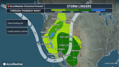 “A large storm will continue to slowly spin through the interior western United States through the end of this week. The storm will bring beneficial rain to drought-stricken areas and help lower wildfire threats, but it will also raise the risk of flash flooding, mudslides and severe thunderstorms. Several rounds of rain will be associated with the massive setup, with rain beginning to shift well inland from the West Coast to parts of the Rockies. A small amount of tropical moisture from Trudy may also become involved over the interior Southwest. “The timing of the heaviest rain in Southern California is expected to be into the first thing Thursday morning,” AccuWeather Senior Meteorologist Adam Douty said. “The storm will bring a general 0.50 to 1 inch of rain to low-elevation coastal areas of Southern California with heavier rain, averaging 1-2 inches on the south- and west-facing slopes of the hills and mountains in the region.” … ” Read more from AccuWeather.
El Niño could bring California a water windfall. Can it keep it?
“California could face a remarkable dilemma this winter, releasing water from reservoirs to prevent flooding while desperately trying to save as much as possible for the next drought. A potentially historic El Niño could bring a parade of powerful storms to parts of the state, AccuWeather Lead Long-Range Meteorologist Paul Pastelok said. But California is entering the rainy season with some reservoirs already nearly full, raising a complicated question: where will all that water go? Lake Casitas in Ventura County was 94% full on Oct. 21 while California’s reservoirs statewide held approximately 104% of their historical average storage for this time of year, according to California Water Watch. That doesn’t mean every reservoir is full, but it illustrates the balancing act facing water managers as they prepare for potentially heavy winter rainfall. … ” Read more from AccuWeather.
This year’s powerful El Niño may preview California’s climate future
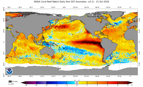 “Flooded highways. Inundated airport runways. Water-filled neighborhoods. Beaches washed away. All of these impacts, and more, could take place this winter as El Niño continues to unfold. Several new reports this week suggest that El Niño’s effects this winter — flooding from temporarily high seas and potential storms — foreshadow a future shaped by human-caused climate change. “This is really a preview of the near future,” said Fraser Shilling, director of the Road Ecology Center at UC Davis. “We can think of it as training wheels. This is what’s coming down the road, and we really need to figure out how to deal with it.” Shilling published a special report highlighting the areas of the state he’s most worried about during El Niño conditions. His concerns span the California coast — Southern California cities already battered by waves, San Luis Obispo, parts of the Bay Area, Stinson Beach and Humboldt Bay. … ” Read more from KQED.
These California highways are most at risk of flooding during El Niño storms
“San Francisco International Airport, the Bay Bridge, Highways 101, 1 and 37 and other critical California infrastructure are vulnerable to “exceptional” flooding and erosion this winter, according to a report published Monday by UC Davis. The report highlights low-lying coasts of Central and Northern California at high risk of a combination of freshwater and seawater flooding during this year’s historic El Niño. Humboldt Bay, San Francisco Bay and Monterey Bay stand out as the most at risk to flooding. … A combination of high tides — already running a foot or more above normal — and repeated heavy rain would be the most damaging, said report author Fraser Schilling, director of the UC Davis Road Ecology Center. “This is the train that’s coming, and at some point we’re going to be at the station,” Schilling said. “One of these days, this thing is going to happen.” It could happen in a month. … ” Read more from the San Francisco Chronicle.
The Kelvin wave has gone — but more are on the way
“Kelvin has left the Southern California coastline – for now. The big Kelvin wave that came through in recent weeks has moved out of the area, according to Andrew Leising, a research oceanographer for the National Oceanic and Atmospheric Administration. The slow-moving warm water waves start at the equator and stretch for thousands of miles across the Pacific Ocean. “They pass through and they keep going,” Leising said. “They keep going up the coastline.” There could be up to four more on the way, he said, coming in spurts every couple weeks in coming months, all with different strengths. “The one that came through was possibly the strongest one,” he said. … ” Read more from the OC Register.
California water reservoir levels and what they mean
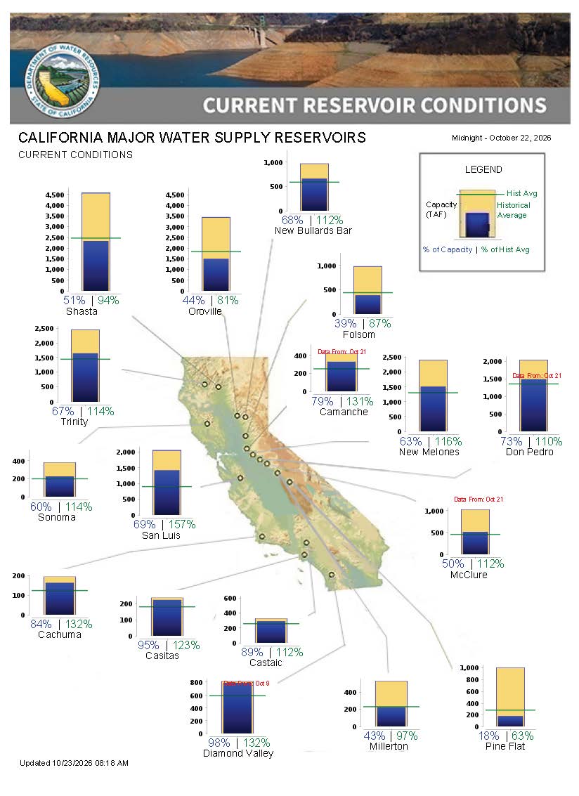 “California has experienced a warm summer, but with a recent storm continuing into Oct. 22, it remains to be seen how it will affect reservoir levels. The Golden State provides nearly half of the U.S.’s vegetables and over three-quarters of its fruits and nuts, according to the California Department of Food and Agriculture, so California’s water levels matter, especially as the state goes through years of on-and-off drought. The storm is expected to bring about 1 inch of rain or less each day across much of the state, with snow at higher elevations, so it could affect reservoir levels. How are the state’s major reservoirs before the storm? The California Department of Water Resources tracks the state’s major reservoirs and releases daily reports. As of midnight on Oct. 21, many reservoirs were over half full and over 100% of their respective historical averages. … ” Read more from the Desert Sun.
Critics blast California’s $180-million water buy as ‘extraordinarily expensive’
“The Newsom administration is coming under fire for paying $180 million to a private investment firm that speculates on water in exchange for a relatively small amount of additional water for Sacramento River salmon. Some environmental advocates fear it could set a precedent for overcharging California taxpayers in a water-constrained future. State officials and supporters of the deal say it’s not that simple because, among other things, it’s a one-time payment for water in perpetuity, not just for one year. This year, the Newsom administration reached the deal to purchase water used by a Northern California farm, saying the goal was to leave the water in the river to help fish and the environment. But Barry Nelson, an advisor for the Golden State Salmon Assn., said the small amount doesn’t justify the cost. “This is extraordinarily expensive water,” said Nelson, who, along with leaders of other environmental and fishing groups, wrote to state regulators raising concern. He said it “seems like a really bad investment for the public.” … ” Read more from the LA Times.
Edward Ring urges California growers to prepare for winter storms and groundwater recharge
“On a recent episode of the AgNet News Hour, Edward Ring, director of water and energy policy at the California Policy Center, returned for Part 2 of his conversation with Nick Papagni. Ring discussed the possibility of a strong El Niño winter, opportunities to replenish California’s groundwater supplies and the policies he believes are threatening the future of Central Valley agriculture. With forecasters discussing the potential for increased winter precipitation, Ring emphasized that California should prepare for both the opportunities and challenges that significant rainfall could bring. While acknowledging the uncertainty surrounding El Niño, he said agricultural water districts should begin developing plans to capture excess stormwater before it flows downstream. “Figure out how to divert as much of that flood water as you possibly can to do recharge,” Ring said. … ” Read more from AgNet West.
Sustainable Conservation celebrates the reauthorization of a vital permitting tool
“Governor Newsom has officially signed Sustainable Conservation-sponsored Assembly Bill (AB) 2045 into law. AB 2045 extends the Habitat Restoration and Enhancement Act (HREA) for another five years and expands its utility by formally including “fully protected species” coverage in the Program. In 2014, Sustainable Conservation’s Accelerating Restoration team first sponsored the HREA to empower smaller-scale restoration projects with an expedited permitting pathway at the California Department of Fish and Wildlife (CDFW). The Program was designed to save time and money while maintaining key environmental protections. Restoration projects throughout California come in all shapes and sizes. Practitioners often need to move quickly to take advantage of seasonal conditions, available funding, construction windows, and opportunities to improve habitat. At the same time, projects still need to ensure measures are in place to protect fish, wildlife, and other environmental resources from any unintended impacts. Restoration-specific permitting pathways, like the HREA, have long track records of ensuring measures are in place to reduce temporary impacts, while enabling long-term environmental gains. … ” Read more from Sustainable Conservation.
Taxpayers face millions of dollars in costs from flooding
“Recent severe weather brought by Post-Tropical Cyclone Rachel has left a trail of millions of dollars of infrastructure damage and property destruction across Southern California. Officials estimate millions of taxpayer dollars will be spent to pay for damage to infrastructure in coastal cities ranging from Long Beach to San Diego, and likewise, private property owners are expected to face millions of dollars of damage. The big picture: The Center Square reached out to various officials to elaborate further on the potential impact on taxpayers, but did not hear back before publication time. What is clear is the damage is extensive in Southern California, which faced a new round of rain and potential thunderstorms on Wednesday. The new, less severe storm hit Ventura, Los Angeles, Orange and San Diego counties. … ” Read more from the San Joaquin Valley Sun.
Atrazine taints tap water for millions – California says it causes cancer. EPA’s plan won’t fix it.
“Three recent developments underscore the health threat posed by atrazine, one of the most widely used herbicides in the U.S. Earlier this month, California’s environmental health agency said it planned to list atrazine as a carcinogen. A new analysis found roughly one-quarter of the miles of rivers and streams in the U.S. are contaminated by it at levels harmful to aquatic life. And a separate study said the Environmental Protection Agency’s proposed approach to curbing atrazine runoff would do little to resolve the contamination problem. Agrochemical giant Syngenta’s atrazine is one of the most widely used herbicides in the U.S., with roughly 70 million pounds applied annually, primarily to cornfields across the Midwest. … ” Read more from the Environment Working Group.
SEE ALSO: Environmental groups sue EPA over weedkiller polluting Western waterways, from Boise State Public Radio
New report: PFAS contamination in California’s rivers and lakes
“PFAS chemicals are contaminating waterways across the United States, putting fish,wildlife and drinking water at risk. That’s the conclusion of a new report from CALPIRG Education Fund, Environment California Research & Policy Center, and Frontier Group. The study, PFAS in America’s Rivers and Lakes, finds that PFAS were detected in California’s waterways at 21% out of 102 testing locations from 2022 to 2024. “This poisoning of our water is what happens when we use toxic chemicals throughout our economy for unnecessary uses such as nonstick cookware, cosmetic products and clothing” said Jenn Engstrom, CALPIRG Education Fund’s state director. “It’s time to turn off the toxic tap.” … ” Read more from the US Public Interest Research Group.
Dan Walters: Californians’ support for cutting carbon emissions wanes as new climate warnings arrive
“Earlier this month, Gov. Gavin Newsom and former Gov. Arnold Schwarzenegger staged a low-key celebration marking the 20th anniversary of Assembly Bill 32, the landmark legislation committing California to immense reductions in greenhouse gas emissions. It was the most notable achievement of Schwarzenegger’s governorship, not only setting a series of deadlines for emissions reductions, but creating as one of its major tools a system for industry buy-in known as “cap-and-trade.” Environmental groups were opposed, favoring direct regulations, but Schwarzenegger insisted. Since then, the state has auctioned off a gradually diminishing number of emissions permits, thus, in theory, incentivizing industries to reduce greenhouse gases. The Los Angeles Times has calculated that early goals were met. But in recent years reductions have slowed, and the 2030 goal of being 40% lower than 1990 emissions levels is highly unlikely. Popular and political support for the state’s commitment to reach virtual zero emissions by 2045 also has been waning. … ” Continue reading from Dan Walters at Cal Matters.
SEE ALSO: What will Becerra and Hilton do on climate?, from Cal Matters
When rivers run low in the American West
“For William E. Smythe, the future of the West was clear. At the turn of the 20th century, long before low snowpacks and the climate crisis, before tens of millions of people moved westward, the New Englander turned western settler understood that water defined how life could be lived in the region. Unlike other parts of the country, much of the West was uniquely arid and would have to be irrigated to support further growth and development. People “will prosper or languish, create high conditions of social life, or lapse into semi-barbarism, in sure response to the manner in which the water supply is owned and administered,” Smythe wrote in The Atlantic’s November 1900 issue. As he traveled through the western states, Smythe saw how early settlers failed to imagine a world where their water needs could not be met. Even in fertile California, the natural cycle of the West surprised settlers: Dry years turned flowered foothills dusty and barren. “The cows would grow thin and sometimes starve to death. People would have to haul water in barrels to their farms just for drinking. Some families would sell out for nearly nothing and move away,” John Steinbeck wrote of the Salinas Valley, a California agriculture hub, in East of Eden. “And it never failed that during the dry years the people forgot about the rich years, and during the wet years they lost all memory of the dry years. It was always that way.” … ” Read more from The Atlantic.
In regional water news and commentary today …
NORTH COAST
Lakeport council receives restoration updates
“At the Lakeport City Council meeting Tuesday, Angela De Palma-Dow, executive director of Lake County Land Trust, presented an update on the design plan for the Kuhlanapo Wetland Preserve, which she said is about 30% complete; last publicly discussed in May 2025. The project aims to clear up much of the algal blooms and the cyanotoxins they create. The Kuhlanapo Wetland Preserve is an ecological protection area located at 446 Soda Bay Road in Lakeport. DePalma-Dow explained the principal focus will be the Manning Creek Delta restoration, expanding the Tule, to replace invasive plants with native plants, as well as incorporate culturally significant plants. … ” Read more from Lake County Record-Bee.
SIERRA NEVADA
California releases Fifth Climate Change Assessment, including new research on the Sierra Nevada
“California has released its Fifth Climate Change Assessment, providing new climate science, projections, and research to help communities, policymakers, and regional leaders prepare for the impacts of climate change. Sierra Business Council (SBC) served as a Lead Author of the assessment’s Sierra Nevada regional chapter, contributing regional expertise to a statewide effort to inform climate resilience and adaptation. The assessment brings together scientific research and updated climate projections to support informed decision-making across California. Its regional and statewide findings are intended to help communities better understand climate-related risks and identify opportunities to prepare for future conditions. For the Sierra Nevada, climate change has implications for the natural systems, infrastructure, water resources, and local economies on which communities depend. The regional chapter offers an important resource for understanding these challenges and informing strategies that strengthen the region’s resilience. … ” Read more from YubaNet.
Near Nevada City, two proposed lakes would feed a 750-MW underground power station that pumps water back uphill
“In the pine-forested ridges of the Sierra Nevada foothills east of Nevada City, a San Francisco-based energy firm has filed federal paperwork for something California has rarely seen attempted at this scale: two entirely new lakes, built from scratch on opposite slopes of the Fish Creek drainage basin, connected by a buried shaft to a powerhouse hidden underground. The project, proposed by RamaFlux Sierra PSH LLC and submitted to federal regulators in April 2026, would generate up to 750 megawatts of electricity — with no river dammed and no existing waterway diverted. Pumped storage hydropower runs on a beautifully simple idea. When the grid has more electricity than it needs — say, on a sunny afternoon when solar panels are overproducing — operators use that surplus to pump water uphill to an elevated reservoir. Hours later, when demand peaks, they release that water back downhill through turbines to generate electricity on cue. The reservoir becomes, in effect, a giant rechargeable battery. … ” Read more from Energies Media.
‘This is not 1849’: California father, son sentenced in illegal mining case
“A father and son from Nevada County were sentenced to jail and ordered to restore land damaged by illegal mining along Keystone Creek near Loganville in Sierra County, prosecutors said. Gregory Arnoldi Jr. of Nevada City and Gregory Arnoldi Sr. of Browns Valley pleaded no contest to felony vandalism of public and private property and misdemeanor charges of water pollution and stream alteration, the Sierra County District Attorney’s Office said. The case involved an illegally built dirt road and mining near the creek. Each man was sentenced to 30 days in county jail, fined $8,135 and placed on felony probation for three years. They are barred from mining during their probation and must pay to design and complete a restoration plan for the damaged properties by Aug. 1, 2027. … ” Read more from the San Francisco Chronicle. | Read via Yahoo News.
Mt. Rose Ski Tahoe banking on El Niño as snow blankets slopes
“Forget Christmas, it’s beginning to look like a white Halloween at Mt. Rose Ski Tahoe. The ski resort just 25 minutes from Reno is targeting a Nov. 6 opening, weather permitting. As of Thursday morning, snow at the top was still falling after starting late afternoon Wednesday. The 1,200-acre resort said it is gearing up to take advantage of the Super El Niño forecast for the Lake Tahoe region this upcoming ski season. Mt. Rose Ski Tahoe said it was the first resort at Tahoe and among the first in the country to begin snowmaking operations. The resort said snowmaking started weeks ago and that it plans to make as much snow as possible during and between storms. … ” Read more from the Reno Gazette Journal.
Cal Fire says wildfire risk remains despite recent rainfall in foothills
“Rain across the foothills is bringing some relief to residents as October comes to a close — but Cal Fire officials warn that the wildfire risk has not been reduced by the recent weather changes. “Don’t fall for it. We’re still a long ways out from being able to burn safely once we get more rain,” said Nick Salas, a Cal Fire Nevada-Yuba-Placer Unit battalion chief. While cooler temperatures and shorter days may make it feel like wildfire season is winding down, California’s fire danger can persist well into the fall and early winter. Salas said the recent rainfall did little to provide meaningful moisture to the vegetation that can fuel wildfires. … ” Read more from CBS Sacramento.
SACRAMENTO VALLEY
Shasta College launches weather balloon to improve atmospheric river monitoring
“Shasta College launched a weather balloon Thursday morning as part of a new program designed to improve monitoring of atmospheric rivers and provide scientists with more weather data for Northern California. The test launch took place between 11 a.m. and noon on October 22 at Shasta College’s main Redding campus. Scientists from the Center for Western Weather and Water Extremes (CW3E) at the University of California, San Diego, conducted the launch in partnership with the California Department of Water Resources and Shasta College. The balloon carries a small instrument called a radiosonde, which collects information about atmospheric conditions as it rises into the sky. The data includes air temperature, relative humidity, wind speed and direction, and air pressure. … ” Read more from Action News Now.
SEE ALSO: Shasta College Selected as Radiosonde Sampling Location for Atmospheric River Program, from A News Cafe
Roseville introduces program to train next generation of water utility workers
“Roseville Adult School has launched a 16-week water distribution certification program to help address a growing shortage of skilled water utility workers and prepare students for careers in the field. “This is a short-term opportunity for Roseville Adult School students who want to start a new career,” said Jason Harm, assistant principal at Roseville Adult School. “Change their life and come up with a certification that’s professional.” Harmony O’Brien, a student in the program, said the opportunity has been transformative for her and her family. “It really impacted me because I was mainly just thinking for my kids and a foundation for my kids. So this is definitely going to not only help me, but help them,” O’Brien said. … ” Read more from KCRA.
BAY AREA
Teenage terns turn up in the Bay, big time
“In August and September, punky-crested white seabirds normally seen in southern climes descended upon the Bay Area in the thousands. Clouds of them swirled at Crissy Marsh, getting rowdy among themselves with their karr-eeks and gaks. Huge gaggles thronged the Pacifica Pier and the Alameda Naval Air Station, their tangerine beaks and hairdos standing out among the seagulls. It terns out they may be here to stay. Elegant terns, previously known for only breeding in a few select locations off the coast of Mexico and Southern California, appear to have established breeding grounds across at least seven sites in the Bay Area, say researchers and longtime birders. This May, birder Tony Brake uploaded photos to eBird of crowds of elegant terns and at least one egg on the shoreline of Brooks Island, a small, shrubby island that’s a half-mile from Richmond. He estimated some 1,800 elegant terns were milling around on the island. … ” Read more from Bay Nature.
Richmond has no data centers. It just banned them for two years.
“On Tuesday, Councilmembers voted to extend a temporary ban on data centers, prohibiting the tech hubs for two years while the city studies how to best regulate the land use. The unanimous vote builds on a Sept. 15 meeting when six of seven councilmembers similarly agreed to a 45-day ban. The most recent vote extends the moratorium on data centers for an additional 22 months and 15 days. Richmond has no data centers and hasn’t received any applications for one, but officials expressed a need to get ahead of what they see as an environmental and health threat to residents. “We have seen the impacts in other communities when data centers are built, so it’s not a hypothetical issue,” Councilmember Claudia Jimenez said. “I want to ensure that community engagement is robust so we don’t see what happened in Pittsburg.” … ” Read more from the San Jose Mercury News.
San Jose data center advances after pushback
“A proposal to reclassify a research facility in North San Jose as a data center is moving forward, after the San Jose City Council rejected an appeal attempting to block the project on environmental grounds, amid a citywide backlash against data center developments. Councilmembers voted unanimously Tuesday — with Councilmember Peter Ortiz absent and Vice Mayor Pam Foley recused due to a financial conflict of interest — to quash the appeal from a coalition of labor groups and concerned residents. They sought to overturn city planners’ July 8 decision to approve a special use permit to operate a data center using up to 20 megawatts of power within an existing research and development building at 300 Holger Way. The permit would allow for interior improvements including the installation of data racks. The facility located just south of Highway 237 is leased to chip maker NVIDIA, which uses it for research and development work, according to the property’s owner, real estate investment firm Menlo Equities. … ” Read more from the San Jose Spotlight.
CENTRAL COAST
Efforts to protect SLO County beavers just got a big funding boost. See how much
“Efforts to preserve and protect the county’s most eager and dam-building residents received a boost after Sen. John Laird secured funding for the San Luis Obispo Beaver Brigade and the Salinas River. This support is one of five projects across SLO County that will bolster community investment and environmental stewardship, the brigade’s news release said. While the awarded amount was not specified, the nonprofit said funding would go towards it helping identify opportunities for conservation, public access and habitat restoration along the river corridor. The Beaver Brigade operates throughout the Central Coast with the mission of creating conditions for beavers to thrive through its beaver dam monitoring and protection program, educational tours for schools and the public, process-based restoration planning, monthly river cleanups and annual beaver festival in SLO’s Mission Plaza. … ” Read more from the San Luis Obispo Tribune.
SAN JOAQUIN VALLEY
Fresno County approves Friant Ranch despite unanswered questions on water
“A new town the size of Fowler was greenlit by the Fresno County Board of Supervisors on Tuesday — despite no answers on the project’s water supply. On Monday, Fresnoland reported that Millerton Lake can hold Friant Ranch’s backup water for only one year — too little to carry the town through a repeat of the 2014-2015 drought. County planners missed the gap because they relied on a 2008 water analysis written before that drought hit. Tuesday’s hearing was the county’s last chance to fix the problem. Supervisors heard their own lawyer confirm Fresnoland’s reporting on the record — and unanimously approved the project’s environmental review anyway. “There’s paper water, and then there’s real water,” Supervisor Luis Chavez said. … ” Read more from SJV Water.
EASTERN SIERRA
Commentary: The Eastern Sierra should not repeat the mistakes of the Gold Rush
Chris Bubser, Mammoth Lakes resident and co-founder of the Gold Isn’t Green Coalition, writes, “For decades, Californians have been taught a sanitized version of the Gold Rush: a story of adventurous prospectors, sudden fortunes and the beginning of a prosperous state. Across the Sierra Nevada, we live with the consequences of the full story. The rush for gold displaced and killed Indigenous people, leveled forests, impacted waterways and left toxic and physical hazards behind, which communities are still facing more than 170 years later. That history is physically present throughout Mono and Inyo counties. Old shafts across the region can collapse or trap people and animals. Tailings and waste rock can contain mercury, arsenic, asbestos and other contaminants that may find their way into nearby waterways. …” Read more from Mammoth Times.
SOUTHERN CALIFORNIA
Rain continues in Southern California, flooding some roadways, prompting rescues
“Scattered showers continued to keep Southern California damp on Thursday, Oct. 22, but the brief autumn rains were expected to give way to a warmer weekend, forecasters said. Numerous showers and isolated thunderstorms moved into western Los Angeles County, such as in Malibu, up to the western San Fernando Valley and the Santa Clarita Valley. A swift-water-rescue team saved two people from the rain-swollen Pacoima Wash in the North Hills and Van Nuys areas: A woman was rescued near Parthenia Street and expected to be taken to a hospital; a man was hoisted from the water by a helicopter crew. Santa Ana winds are expected next week, with the possibility for more rainy weather after Halloween, according to the National Weather Service. … ” Read more from the LA Daily News.
Newport Beach adds sand to build up beach in battle against the sea
“It’s a race against the tides. Newport Beach is scrambling to get sand on its beaches ahead of a mega high tide expected to hit early next week, and to add protection at the coast as forecasts warn of king tides and more Kelvin waves in coming months that could again threaten to flood the Balboa Peninsula. City officials declared an emergency this week ahead of the El Niño winter and following flooding that already caught the town off guard on Oct. 9 when a hurricane swell and high tides, along with elevated sea levels due to warm water conditions, combined to send seawater up and over already-eroded beaches and into streets and homes. The city on Monday, Oct. 19, also approved a contract for about $1.5 million to scoop an estimated 100,000 cubic yards of sand, possibly up to 200,000 cubic yards, built up in the Santa Ana River mouth to spread on beaches between groin jetties throughout 36th and 62nd streets. That work started on Wednesday, Oct. 21. … ” Read more from the OC Register.
Doheny Desalination Project changes approved by California Coastal Commission
“Desalination Project on Oct. 7, allowing South Coast Water District to relocate its seawater intake wells as the district works toward a mid-2027 construction start. Originally planned for the Doheny State Beach campground, the wells will instead be placed in the north day-use area in light of further geological studies that found the initial location would not provide enough seawater for the plant. South Coast Water District Assistant General Manager and Chief Engineer Marc Serna said the district is more confident the new location will produce the water needed for the project. “The movement of the slant wells was done so that we could ensure that we were getting the adequate production from the wells,” Serna said. … ” Read more from the Dana Point Times.
SAN DIEGO
County green streets help filter El Niño stormwater
“When stormwater runs across streets, sidewalks, parking lots, and other surfaces, it picks up pollutants. That water then flows into the storm drain system and reaches local creeks, rivers, lakes, and the ocean—usually without treatment. The County’s Green Streets infrastructure (GSI) — part of a broad approach to managing stormwater and reducing flood risks — acts as a natural filter. These systems slow stormwater, capture pollutants, and let water soak into soil and plant areas. GSI projects use features such as biofiltration basins, tree wells, vegetated swales, trash capture devices, and permeable pavement. These natural systems help remove trash, bacteria, nitrogen, phosphorus, and other pollutants from stormwater. Many projects also improve water infiltration, reduce flooding, and make walking safer and easier. … ” Read more from Picket Fence Media.
Along the Colorado River …
The Colorado River Basin’s snowy upper half lost nearly twice the groundwater of the desert below
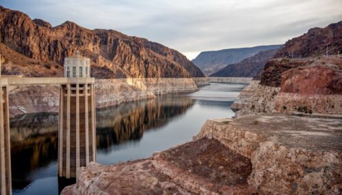
“The Colorado River Basin’s latest groundwater shock did not hit hardest in the hottest places. During the 2020-2022 drought, the river’s snowy upper basin lost nearly twice as much groundwater as the desert lower basin, challenging the long-standing assumption that the mountain headwaters are the system’s more drought-resilient half. According to Earth.com, the 2020-2022 drought drained an estimated 4.6 trillion gallons of groundwater from the upper basin and about 2.5 trillion gallons from the lower basin. In the upper basin, that worked out to an average depletion of about 1.6 trillion gallons per year. Published in the journal Water Resources Research, the study tracked groundwater changes from October 2003 through September 2023 and found that the Colorado River Basin has lost about 15 trillion gallons of water since 2004, with groundwater accounting for about half of that decline. … ” Read more from The Cool Down.
Interior Secretary responds to Arizona water dispute
“U.S. Interior Secretary Doug Burgum defended the federal government’s Colorado River water decisions during an exclusive interview with KOLD News 13 reporter Peyton May. The interview comes as Arizona and Nevada challenge the Department of the Interior over how it is handling Colorado River shortages. Arizona officials, including Governor Katie Hobbs, argue that proposed reductions place too much responsibility on Lower Basin states while failing to hold Upper Basin states accountable. Burgum disagreed. “We believe that the governor is wrong on this topic,” Burgum told KOLD News 13. He also questioned whether the lawsuit would succeed, arguing that the states have not demonstrated an injury sufficient to support their legal challenge. … ” Read more from Western Water.
Tribes weigh legal action against feds over Colorado River cutbacks
“The Gila River Indian Community may be the next Colorado River water user to sue the federal government after Arizona joined Nevada on Oct. 16 in a lawsuit challenging the Interior Department over its plan to manage water supplies on the drought-stricken river. Nevada filed suit in federal district court on Aug. 24, three days after Interior Secretary Doug Burgum signed the plan to restrict water use in Arizona, California and Nevada, collectively known as the Lower Basin states. The plan will govern management of river operations at least through 2028. Gila River issued a statement on its Facebook page Oct. 16 about Arizona joining Nevada’s lawsuit. “The Arizona Department of Water Resources’ action is intended to protect the interests of all in Arizona as this litigation proceeds forward, and the Community supports ADWR in this move,” said Gila River Gov. Stephen Roe Lewis. “It is unfortunate that we have arrived at a place where litigation is becoming the only way to resolve the complex issues regarding future Colorado river operations,” he said. … ” Read more from Arizona Central. | Read via the Fresno Bee.
Wet-year forecast shows Lake Powell rebound
“A new federal study offers a look at what could happen to the Colorado River’s major reservoirs if the basin receives substantially more water than normal over the next two years. The Bureau of Reclamation released its October 2026 Probable Maximum 24-Month Study on October 15. The report examines how reservoirs throughout the Colorado River system might respond to unusually wet conditions through September 2028. Under this scenario, Lake Powell could gain more than 88 feet in elevation by September 2027, compared with its September 2026 level. Lake Mead’s recovery would take longer. The study projects that its water level would remain relatively low through 2027 before rising sharply during 2028. These are not predictions of what will happen. They are estimates based on one possible set of weather and river conditions. … ” Read more from Western Water.
Falling water, falling visits: Arizona town faces uncertain future
“Mike Farrow looked at the kids running across the emerald-green grass of this unlikely desert town and wondered what their future held. On a warm October evening, city police officers and firefighters celebrated National Night Out with their community. As he watched, Farrow, the city’s vice mayor, thought about the shrinking water level at Lake Powell and its effects on Page and the broader community, including the local Navajo and Hopi people. The lake anchors the economy of the tourist city, population 7,100, and the water level has been declining for years. Today, it sits about 21.6% full, up just slightly from the historic low it fell to this summer. Hydrologists say climate change is altering long-term precipitation trends and the lake will likely never be full again. Pointing to a child, Farrow said: “If I take the lake away from him, am I helping him or hurting him? If I take away the lake from those kids, what does that mean for jobs?” … ” Read more from the Arizona Daily Star.
Scottsdale faces a 17% cut to its Colorado River water supply, but residents won’t feel it right away
“Scottsdale is facing a future with less water from the Colorado River, but at least in the short-term, residents may not feel much impact. The city is anticipating a 17% cut in its Colorado River supply as soon as January. But city officials say the impact on residents won’t be immediate, because the city is not currently using all of its allocation — leaving a buffer between the cuts and what’s actually used. “We have a lot of water. Our taps are not running dry,” Scottsdale City Councilwoman Jan Dubauskas said. … ” Read more from Channel 15.