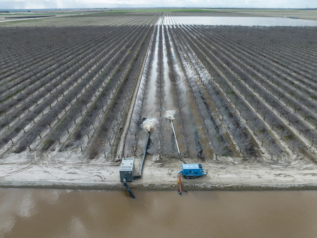
Groundwater basins can serve as large underground reservoirs, storing water during wet periods for use in drought years. When water rights and environmental requirements are met, excess flood flows can be directed underground to replenish aquifers, reduce flood risk and improve drought preparedness. Recharge is becoming more important as climate change reduces the Sierra Nevada and Cascade snowpack and brings greater swings between drought and intense storms. Well-planned projects can provide multiple benefits, including water-supply reliability, aquifer replenishment and ecosystem enhancement.
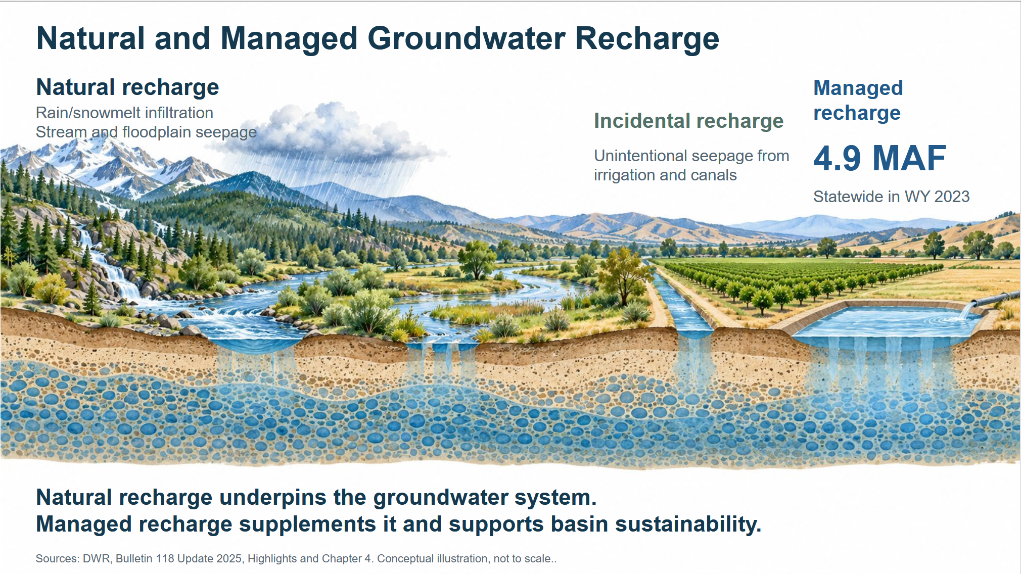
Twelve years into implementation of the Sustainable Groundwater Management Act, more than 250 groundwater sustainability agencies are carrying out nearly 2,000 projects and actions under more than 100 groundwater sustainability plans. More than 500 proposed projects focus on recharge and could add an estimated 1.5 million acre-feet of water supply annually. Recharge reported to the Department of Water Resources varies widely with conditions—from about 200,000 acre-feet in dry years to 4.9 million acre-feet in wet 2023.
At the California Water Commission’s September meeting, a forecasted Super El Niño added urgency to a broader discussion of groundwater recharge readiness. State and local representatives examined how agencies could prepare to capture high flows if an unusually wet winter developed, while also building long-term capacity for future storms. State speakers included Steven Springhorn, technical assistance section lead at the Department of Water Resources; Amanda Montgomery, permitting program manager in the State Water Resources Control Board’s Division of Water Rights; and Adam Weinberg, the California Department of Fish and Wildlife’s statewide SGMA coordinator. Their presentations outlined state responsibilities for recharge, followed by local perspectives on project opportunities, challenges and implementation.
HOW GROUNDWATER RECHARGE WORKS
Groundwater recharge generally falls into two categories. Natural recharge occurs as rain and snowmelt infiltrate the ground and as water seeps from streams and floodplains. Managed aquifer recharge involves intentionally directing water underground to supplement natural recharge and support basin sustainability.
 Water used for managed recharge may come from several sources:
- Water available under existing rights and permits
- Stormwater, particularly in urban areas
- Recycled water
- Water diverted under temporary permits
- Floodwater diverted under Water Code Section 1242.1. Enacted after the 2023 floods, the provision allows diversions from high-flow rivers under specified flood conditions. It was used in 2023 to divert about 400,000 acre-feet across California, primarily in the San Joaquin Valley.
“At DWR, our number one priority is to protect life and property any time it floods, and so that is the number one priority when flooding happens: flood response and flood management,” said Mr. Springhorn. “After that is being worked on, then we start to talk about what to do with that high-flow water. So we want to make sure that all this recharge discussion isn’t taken away from being flood-safe first, and then we’re recharge-ready—that is essentially the goal.”
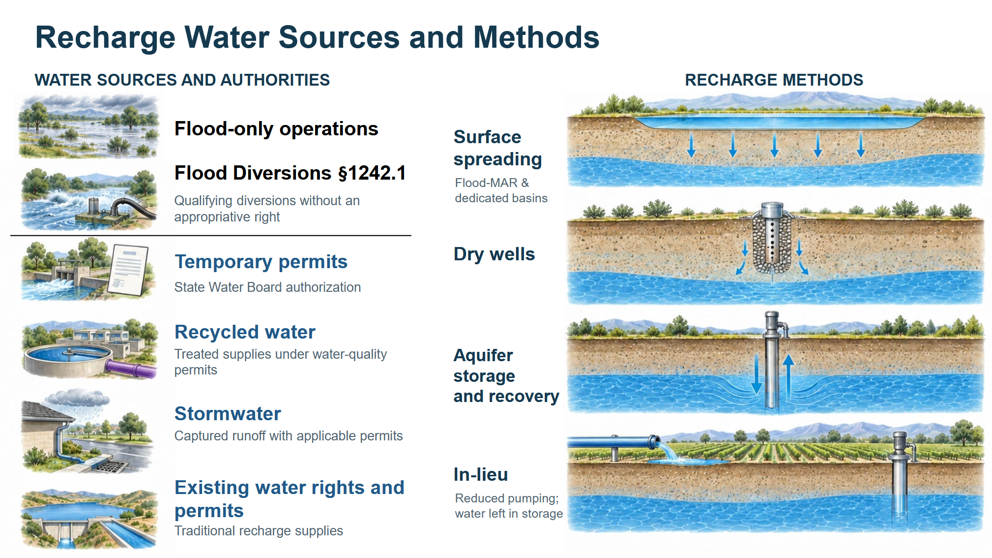
Managed aquifer recharge generally uses four methods:
- Infiltration: Water is applied to the land surface and allowed to soak into the ground through agricultural managed aquifer recharge, dedicated recharge basins or similar approaches.
- Dry wells: Water is directed into wells that allow it to bypass shallow confining layers that could otherwise slow infiltration or cause ponding.
- Aquifer storage and recovery: Water is injected directly into an aquifer through wells that may extend hundreds of feet underground. These projects require permits from the regional and state water boards.
- In-lieu recharge: Surface water is supplied in place of groundwater, allowing users to reduce pumping and leave groundwater in the aquifer.
Local agencies carry out most recharge projects in California. Preparing to capture water when it becomes available requires year-round work, including identifying suitable land and willing partners, readying conveyance systems and recharge basins, and ensuring projects operate safely and responsibly.
GETTING RECHARGE READY
Recharge projects are underway across California, but implementation remains complex. DWR’s work with hundreds of local agencies has identified recurring challenges as well as opportunities to address them.
Recharge readiness depends on aligning four elements before high flows arrive and sustaining that work between wet years:
- Water and authority: Water must be available, and agencies must have the legal authority to divert and use it.
- Infrastructure and partnerships: Recharge requires conveyance facilities, groundwater basins with suitable capacity and local partnerships to plan and operate projects.
- Protection and accountability: Accurate water accounting is essential to an efficient, effective recharge system, and additional work is needed to strengthen these practices.
- Funding and coordination: Existing and forthcoming state funding, including Proposition 4 resources, must be coordinated and directed toward projects that provide the greatest benefit.
Because high flows can arrive quickly, agencies must be prepared to capture them while continuing to build local and statewide recharge capacity between wet years.
THE ROLES OF THE STATE AGENCIES IN GROUNDWATER RECHARGE
Three state agencies provide the framework for groundwater recharge in California. The Department of Water Resources oversees groundwater sustainability plans and provides technical, planning and financial assistance. The State Water Resources Control Board administers water rights and water quality requirements and may intervene under SGMA when necessary. The California Department of Fish and Wildlife reviews and authorizes projects to protect fish, wildlife and habitat.
“Locals lead implementation, but it’s within this overall framework that our state agencies have created and are administering,” said Mr. Springhorn. “So we all have to be working together to make it as efficient as possible.”
The role of the Department of Water Resources
DWR supports groundwater recharge through two primary roles: regulatory oversight of groundwater sustainability plans and technical assistance that helps local agencies understand basin conditions and advance initiatives such as Flood-MAR and Flood Diversion and Recharge Enhancement.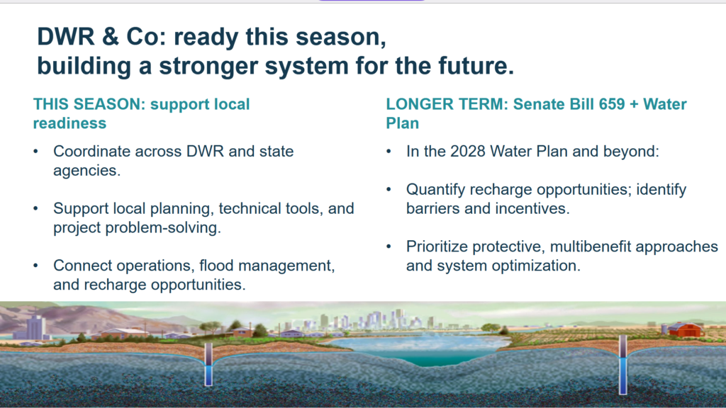
“Although these two important roles of our groundwater team are really in the center of recharge, we work very closely across the department and are trying to work closer each day because so much of moving water, understanding when water is going to be in the system or not,” said Mr. Springhorn. “A lot of other parts of our department are experts in that, and so we’re trying to make sure that we have a really cohesive team across the department and working on all aspects to make recharge happen. We’ve been ramping up and providing technical assistance and project support to help locals implement projects on the ground.”
DWR provides GSAs with funding, planning support and technical assistance intended to build on successful local efforts, expand effective projects and improve regional coordination.
Current efforts include continued Flood-MAR and flood-diversion support, coordination among DWR’s flood and groundwater teams, groundwater characterization and monitoring, and financial assistance from several recharge-related funding programs. A bimonthly recharge-readiness webinar series is scheduled through February 2027.
LEARN MORE: https://www.water.ca.gov/Programs/Groundwater-Management
The role of the State Water Board
Amanda Montgomery, permitting program manager in the State Water Resources Control Board’s Division of Water Rights, described the role of the State Water Board in authorizing surface-water diversions for groundwater recharge, administering water rights and providing applicants with permitting guidance. The board has issued permits for groundwater recharge—known in its terminology as underground storage—for more than a century, with increased emphasis since SGMA took effect.
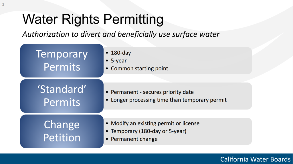 Two temporary water-right permits are available for diverting surface water to groundwater recharge: a 180-day permit covering one wet season and a five-year permit covering five successive wet seasons.
Temporary permits are often the entry point for projects seeking a new surface-water diversion. They generally take three to four months to process, include public notice and resolution of objections, and allow agencies to test a project before seeking a standard permit.
To be ready when high flows occur, applicants must address three common challenges:
- Project planning: Funding, project design and environmental review must be completed in time for the wet season. Executive orders previously suspended CEQA requirements for some temporary permits, but that coverage ended in the spring, so applicants must now prepare a CEQA document.
- Water availability: Applicants must show that water remains available after accounting for existing rights and in-stream needs for fish and wildlife.
- Public concerns: Applicants must address objections and proposed protective conditions.
The board offers pre-filing consultations to help applicants prepare. Filing fees are reduced for applications submitted at least 120 days in advance, and a five-year temporary permit carries the same application fee as a single-season permit.
For water availability, the board created a streamlined review pathway in 2019 that may be used for temporary or standard permits. “Basically, what we were looking for was an easy set of diversion criteria to be able to say this water can be taken without harming in-stream resources or senior demand,” said Ms. Montgomery.
One pathway uses the highest 10% of flows, or 90th-percentile flows, based on existing stream-gage data calculated by the U.S. Geological Survey. About half of temporary permits use this approach. A second pathway allows threatened flooding to serve as a diversion trigger. Many temporary permits combine this flood trigger with percentile-based flow criteria, while other projects develop watershed-specific triggers.
Early community outreach can also shorten permitting by identifying likely concerns and incorporating protective conditions into project design before an application is filed.
Water Code Section 1242.1 provides a separate, permit-free pathway for qualifying flood diversions for recharge through 2029, unless extended. Participants must meet statutory conditions and comply with notice and reporting requirements; the board publishes submitted reports and provides technical guidance. The pathway remains limited, however, because an earlier executive order had covered a requirement linking diversion triggers to qualifying local flood plans, and many communities do not have plans containing the necessary information.
“The greatest challenge that we see in 1242.1 right now is similar to what I was talking about with CEQA. We had an executive order that was covering the requirement to have your diversion trigger be based on a local plan, so either adopted in the current general plan for the area, or in what’s called a Water Code 8201 local plan of flood management or flood control. Local plans are common, but having the right information for flood control is not common, and having that other type of plan is not common. So right now, if we enter into a super El Nino situation, many parties will not be able to use the 1242.1 pathway because we don’t have an executive order like we had in the past years.”
LEARN MORE: https://waterboards.ca.gov/waterrights/water_issues/programs/applications/groundwater_recharge/
The role of the Department of Fish and Wildlife
Adam Weinberg, the California Department of Fish and Wildlife’s statewide SGMA coordinator, described the role of the Department of Fish and Wildlife in reviewing and authorizing groundwater recharge projects, protecting fish, wildlife and habitat, and providing technical guidance to state and local partners.
CDFW’s mission is to manage California’s fish, wildlife, plant resources and habitats for their ecological value and public use and enjoyment.
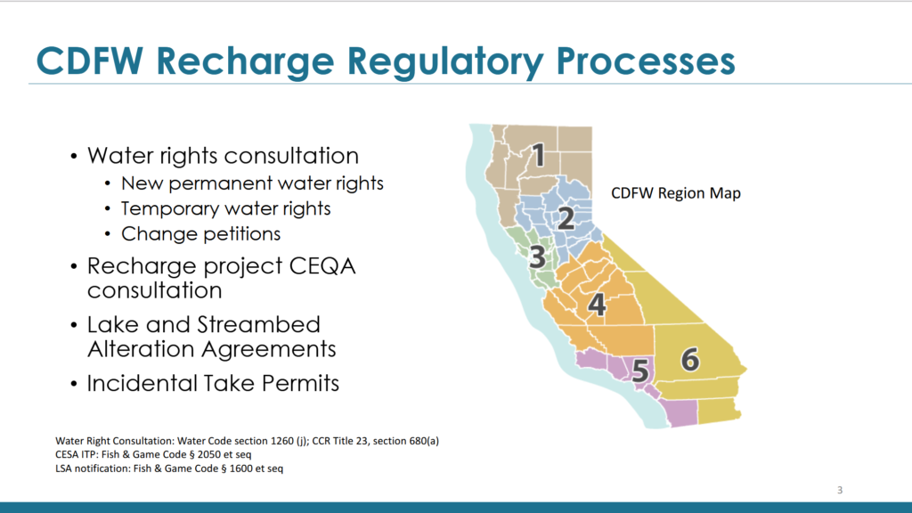
CDFW has regulatory and nonregulatory responsibilities in groundwater recharge. Much of its regulatory work is conducted through regional offices, whose areas of responsibility are shown on the slide.
CDFW’s principal regulatory role is consultation. Before submitting a final application to the State Water Board for a temporary or permanent water right, project proponents must consult CDFW and provide enough information for the department to assess environmental effects and recommend measures to avoid or reduce harm. Applicants must then make a bona fide effort to identify effects on fish and wildlife and describe protective measures in the application. Before approving the application, the State Water Board must consult CDFW to determine whether that effort was made.
Consultation is also required for petitions to change an existing water right, including water transfers. Project proponents are encouraged, though not required, to consult CDFW before circulating CEQA documents for proposed diversions and related infrastructure.
Other permits may apply. Construction in a streambed or bank may require a Lake or Streambed Alteration Agreement, and projects that could affect a state-listed species may require an incidental take permit. These requirements can apply to aquatic species at the diversion site or to terrestrial species and habitat in riparian areas or at the recharge location.
“We encourage project proponents to seek consultation with CDFW prior to submitting a notification for a Lake or Streambed Alteration Agreement or an incidental take permit application,” said Mr. Weinberg.
CDFW also has nonregulatory responsibilities. “For instance, the primary role of my job as the statewide SGMA coordinator is to provide coordination, guidance and technical assistance to our regional staff in their review and assessment of groundwater sustainability plans,” he said. “Regional staff also receive technical support from our program hydrogeologist on SGMA and other groundwater issues. CDFW staff and management also participate in groundwater recharge coordination and advisory groups with our agency partners.”
A central challenge is balancing the water-supply benefits of recharge with the ecological benefits of functional flow regimes. CDFW’s review can also be constrained when applicants do not share environmental analyses, begin consultation shortly before filing or choose not to incorporate the department’s recommendations.
Mr. Weinberg also identified opportunities for projects that provide ecological, water-supply and flood-control benefits. The Lower Elkhorn Basin Levee Setback Project and Dos Rios State Park expanded river access to floodplains, increasing recharge while creating thousands of acres of wildlife habitat and reducing downstream flood risk. Outside floodplains, recharge can also replenish aquifers that support in-stream and terrestrial groundwater-dependent ecosystems, known under SGMA as GDEs.
LEARN MORE: https://wildlife.ca.gov/Conservation/Watersheds/Groundwater
LOCAL PERSPECTIVES ON GROUNDWATER RECHARGE
Kaweah Subbasin
Aaron Fukuda, chief executive officer of the Tulare Irrigation District and the Mid-Kaweah Groundwater Sustainability Agency, described how decades of local investment, groundwater accounting and grower incentives are helping the district capture more water when wet-year opportunities arrive.
The Mid-Kaweah Groundwater Sustainability Agency, which includes the Tulare Irrigation District, is part of the 441,000-acre Kaweah Subbasin. The critically overdrafted basin is managing several undesirable results identified under SGMA, including through groundwater recharge projects and management actions.
One of the district’s most important recharge assets is its 300-mile network of earthen canals across 65,000 acres. When full, the canals can recharge about 100 cubic feet per second, or 200 acre-feet per day.
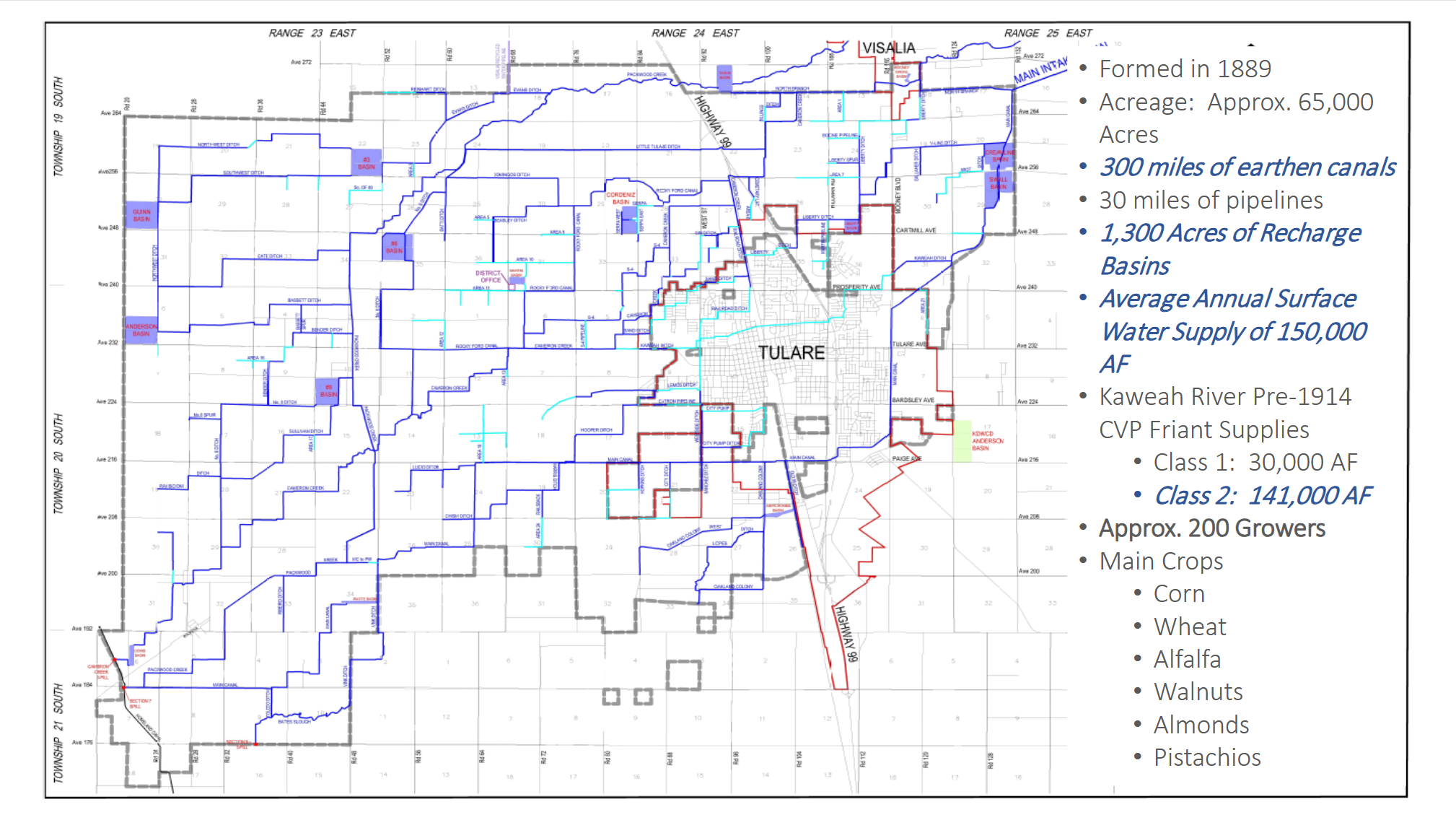
The district also has 1,300 acres of strategically located recharge basins, many developed with partner agencies such as the Kaweah Delta Water Conservation District. Together, the basins can recharge about 325 cubic feet per second, or 650 acre-feet per day, when the system is full.
A recharge basin near Okieville was built to address declining groundwater levels. Unlike facilities that generally receive water only during wet years, the Okieville basin receives water annually based on the allocation provided to district landowners.
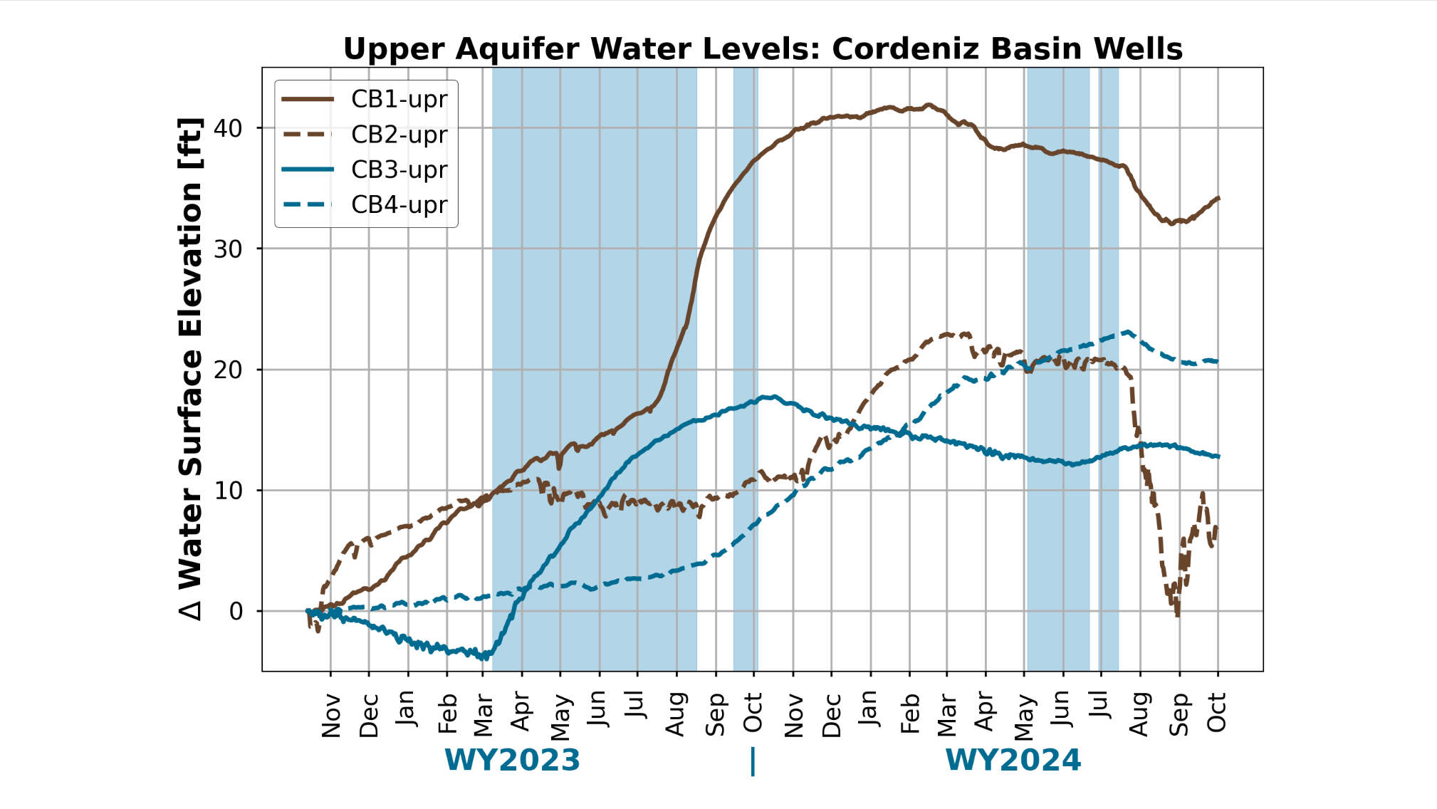 The district’s winter irrigation recharge program illustrates how groundwater accounting can create demand for floodwater. In 2022, the district established a pumping cap, fees and a system that tracks groundwater use in 30-day increments and credits recharge. When atmospheric rivers arrived in 2023, growers generated 800 cubic feet per second of demand within 24 hours, prompting the district to activate its full system. The district diverted a record 420,000 acre-feet that year.
“So we’re looking at programs this year to incentivize growers and telling them to get their fields ready now if this El Nino year happens,” said Mr. Fukuda.
Madera County
Stephanie Anagnoson, director of water and natural resources for Madera County, described how the county is combining groundwater credits, flood-control authority and grant funding to expand recharge across a large and economically important agricultural region. She also serves as flood control manager and general manager of three county groundwater sustainability agencies.
Madera County covers more than 2,000 square miles, extending across the Sierra Nevada to Devils Postpile, and has a farm-gate value of about $2 billion, led by almonds, pistachios, dairy products and grapes. Recharge incentives are central to the county’s approach: Under a policy developed in 2023 and adopted in 2024, growers in the Madera County GSA can receive credit for applied surface water, including qualifying recharge completed in 2023.
Because of subsidence concerns, credited water must be extracted from the same aquifer where it was recharged. Water applied above the Corcoran clay, for example, cannot later be pumped from a deep well.
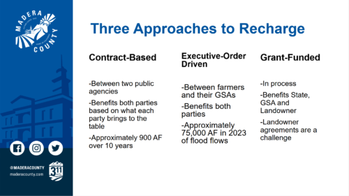 Recharge in the county follows three approaches: contracts between public agencies, flood diversions authorized under the 2023 executive order, and longer-term projects supported by grants.
The county’s longest-running effort is a 10-year partnership with Madera Irrigation District. When excess surface water is available, the district provides it at no cost for recharge in a county road basin with unused stormwater capacity, demonstrating how agencies can pair existing water and land through a traditional agreement.
The 2023 executive order provided a less traditional pathway by allowing flood-control agencies to authorize diversions where land faced inundation, including much of the Madera County valley floor. Combined with GSA recharge credits, that authority encouraged growers near waterways—particularly the Eastside Chowchilla Bypass—to move floodwater underground.
Grant funding supports projects that fill remaining gaps and provide multiple benefits, such as recharge basins that also reduce flood risk or stormwater basins that create habitat.
“All of the approaches that we have, whether it’s grant-funded or under the executive order or a traditional approach with contracts, allow for recharge,” said Ms. Anagnoson. “So they are all really beneficial. The contract-based approach really favors those who either have land that they can allow recharge to occur on or water. The executive order approach favors people who are in the right place near a waterway to help with inundation of land, and then we’ve used grants to fill in gaps.”
Pajaro Valley
Brian Lockwood, general manager of the Pajaro Valley Water Management Agency (PV Water), described how the agency combines managed aquifer recharge, recycled water, surface water and landowner incentives to reduce groundwater pumping and slow seawater intrusion in the critically overdrafted Pajaro Valley basin.
Formed in 1984 and designated a groundwater sustainability agency in 2015, PV Water serves portions of Santa Cruz, Monterey and San Benito counties, including Watsonville. The roughly 70,000-acre basin supports an agricultural economy valued at about $1 billion annually.
Recharge comes from rainfall infiltration, enhanced stormwater recharge, managed aquifer recharge and in-lieu recharge. Water diverted from waterways is stored in infiltration basins and later recovered for delivery, while tertiary-treated recycled water and surface water reduce customers’ need to pump groundwater.
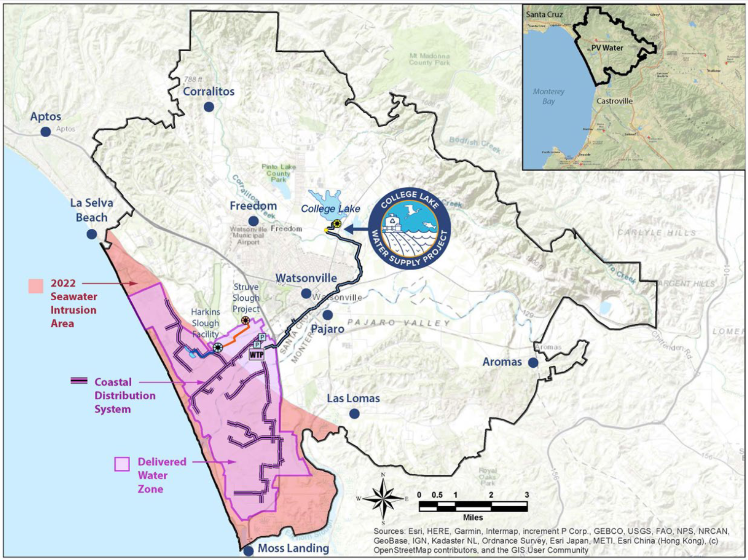
The map on the lower left shows PV Water’s service area, seawater intrusion as of 2022 and the area where surface water, recycled water and recovered groundwater are delivered to agricultural customers. Supplies come from the College Lake project, the Harkins Slough infiltration basin and inland wells. “We can deliver at present around five to 6,000 acre-feet a year through our pipelines to customers, and in turn they keep about that much water in the ground, and that’s a real benefit to us,” said Mr. Lockwood.
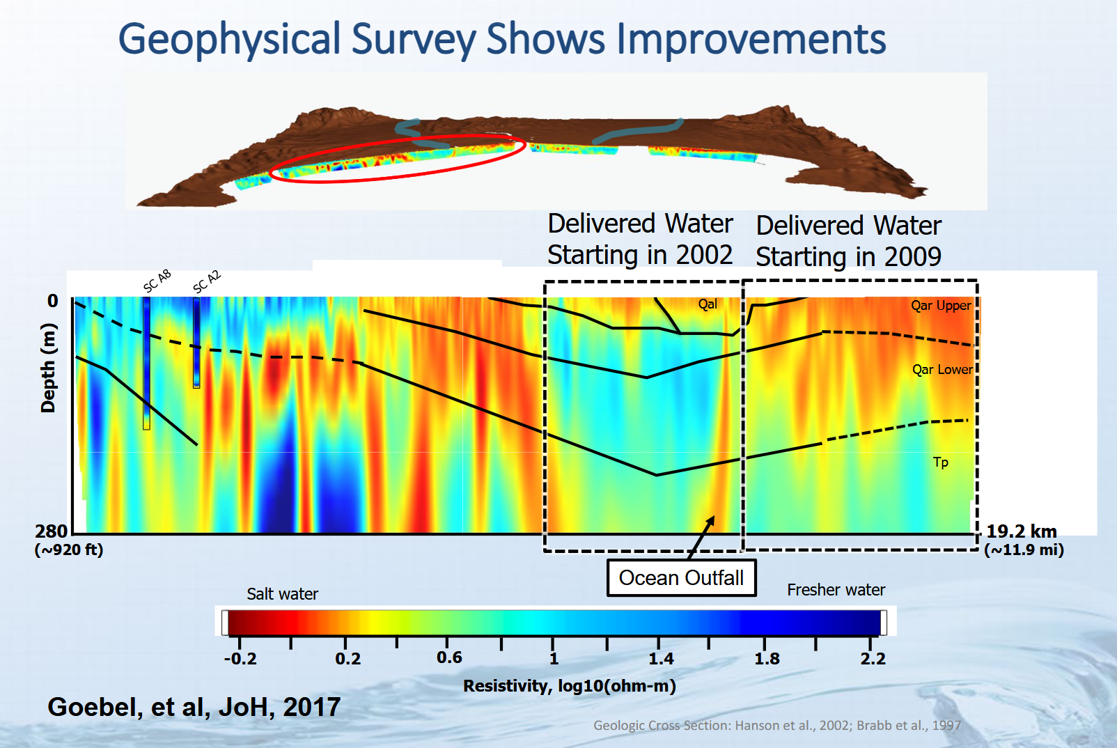
A 2017 study (upper right) illustrates saltwater intrusion in Monterey Bay’s coastal aquifers and shows fresher water where PV Water began surface-water deliveries in 2002 and expanded them into Monterey County in 2009. “In that area where we’ve been delivering water the longest, you can see it’s noticeably bluer than it is on either side,” said Mr. Lockwood. “We started delivering water to Monterey County in 2009 when the water recycling facility came on, and since then have extended our pipeline a little further to the north, which will help to alleviate seawater intrusion in that area.”
PV Water’s Recharge Net Metering Program encourages landowners to maintain recharge basins by offering rebates equal to 50% of the agency’s augmentation charge, based on the volume infiltrated. Funded through delivered-water sales and groundwater pumping fees, rebates have ranged from $1,000 or $2,000 in drought years to more than $50,000 in wet years. “Part of why we pay this rebate to the landowners is because each year, after the water infiltrates into the ground, there is some level of maintenance that needs to happen, and this helps the property owners cover the cost of maintaining the basins,” said Mr. Lockwood.
Planned projects would expand this approach. PV Water is pursuing a relocated Harkins Slough facility, a second infiltration basin and more than 20 recovery wells to store winter flows for summer use. The Watsonville Slough System project is in permitting, additional recharge net-metering sites are being developed with state support, and the Pajaro River Flood Risk Reduction Project could increase recharge by setting back levees and expanding the floodplain.
Southern California
Adam Hutchinson, recharge planning manager for the Orange County Water District, described how Southern California agencies use a diverse water portfolio, regional coordination and reservoir operations to expand managed aquifer recharge and strengthen long-term water supplies.
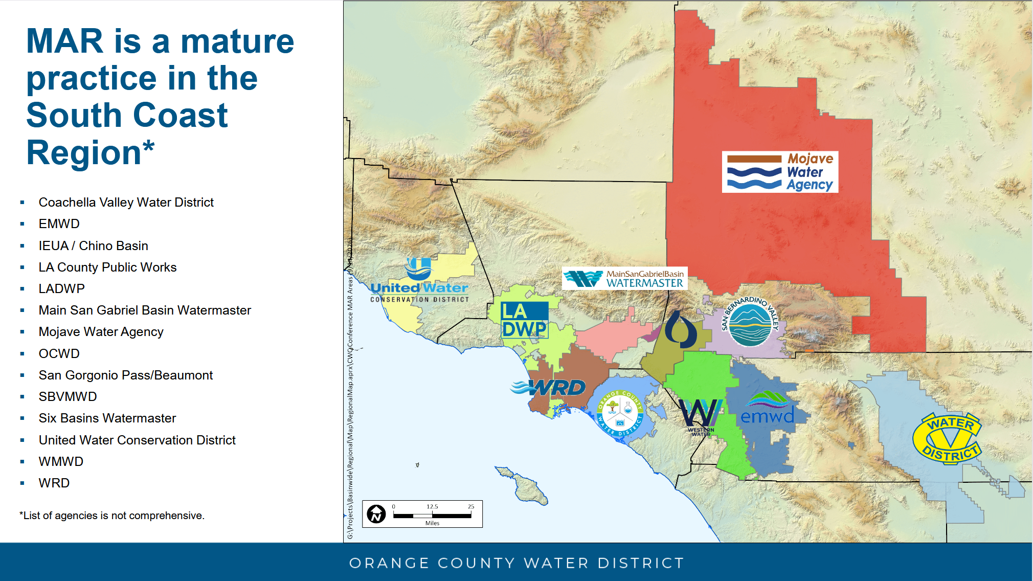
Managed aquifer recharge has supported Southern California’s water supply for decades. The Orange County Water District has operated a recharge system for more than 90 years, using stormwater, flood flows, imported water and recycled water to help sustain the region’s groundwater basin.
Watershed-scale planning offers opportunities to use existing infrastructure more effectively. Through the Proposition 84-funded Santa Ana River Watershed Conjunctive Use Program, agencies reserved storage in groundwater basins across the watershed to bank wet-year water through managed aquifer recharge or in-lieu recharge for use during dry years. A decision-support tool helped identify the facilities needed to address system gaps and improve the value of existing investments. “DWR was very flexible in allowing us to repurpose some of that funding to really go where it was really needed to make it more impactful,” said Mr. Hutchinson. “It’s a great project, and managed aquifer recharge is really central to making this work.”
Forecast-informed reservoir operations provide another watershed-scale opportunity. Studies at Prado Dam have advanced to implementation after 10 years, while Seven Oaks Dam is moving from a preliminary viability review to a full assessment. “This is the first example, I believe, of two FIRO projects on the same river in the same watershed,” said Mr. Hutchinson. “The goal is to store stormwater temporarily without compromising the flood risk management purposes of the dams themselves, and this enhances water supply through managed aquifer recharge, and also has habitat benefits as well. So these are multi-purpose, multi-benefit projects.”
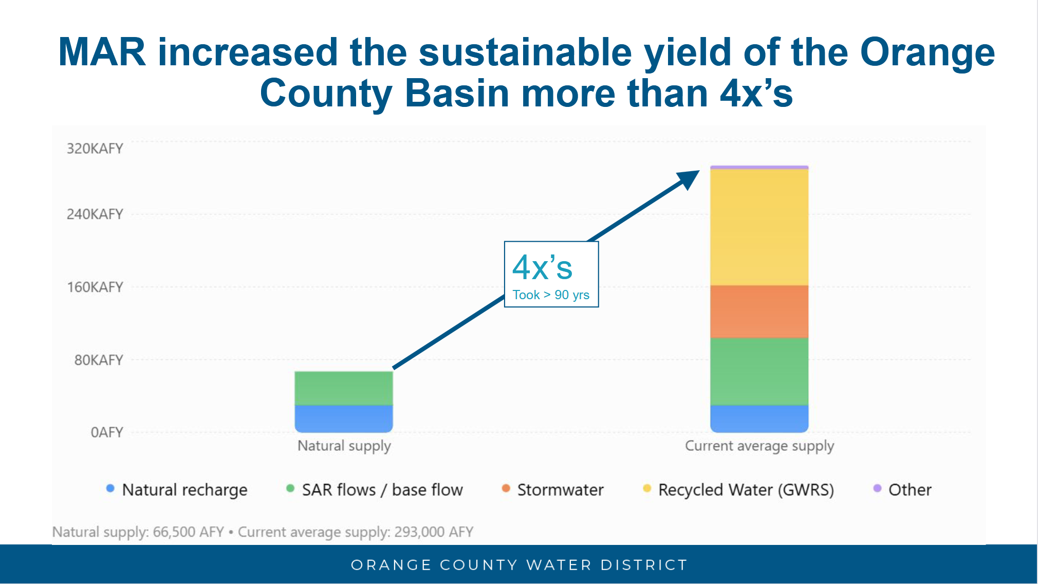 “These projects will allow us to have more water,” said Mr. Hutchinson. “When Orange County Water District became an agency in 1933, we were overdrafted, seawater intrusion. We had a lot of problems, but through our investments in recharge capacities and water sources, we are now able to do four times more pumping out of the basin, what Mother Nature would provide. So this can happen. You just need to keep your eye on the ball and work hard at getting projects in the ground and looking at a diverse portfolio of water supply. But it can be done, and that’s why we’re here today to promote MAR on a statewide basis.”
Sacramento Valley
Steven Springhorn concluded the local presentations with an overview of recharge activity in the Sacramento Valley. The Yolo County Flood Control and Water Conservation District has used temporary permits for about a decade to capture water during wet seasons and has also applied for a standard permit.
Other efforts are advancing across the valley. The Tehama-Colusa Canal Authority and districts along the canal are exploring ways to expand recharge, while Butte County has piloted flood diversions under Water Code Section 1242.1.
The Sacramento region has long used recharge and conjunctive management through agencies including the Regional Water Authority, Sacramento Groundwater Authority and the city of Roseville. Local projects include aquifer storage and recovery, early Section 1242.1 diversions from the Cosumnes River, a developing regional water bank and a Section 1242.1 diversion by the Dunnigan Water District.
The Northern California Water Association and the Department of Water Resources also convene the Sacramento Valley Flood Diversion and Recharge Enhancement Working Group. Over the past 18 months, the group has examined regional opportunities and challenges and provided technical support for recharge projects.
In closing …
The presentations underscored that groundwater recharge depends on more than wet weather. Capturing high flows requires permits, infrastructure, funding, environmental review and partnerships to be in place before storms arrive. Whether preparing for a possible Super El Niño or future wet years, coordination among state agencies, local water managers and landowners will be essential to expand recharge while protecting communities, water rights and ecosystems.
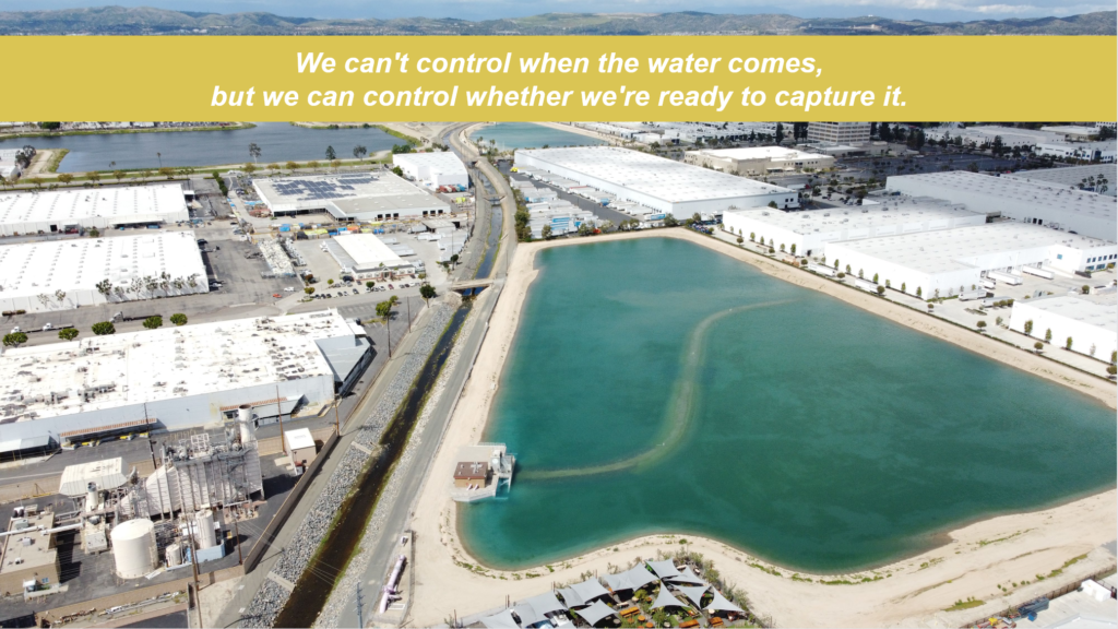
“We can’t control when the water comes, but we can control whether we’re ready to capture it,” said Mr. Hutchinson. “So hopefully, we can keep growing the portfolio and be recharge-ready for future storms.”