Several news sources featured in the Daily Digest may limit the number of articles you can access without a subscription. However, gift articles and open-access links are provided when available. For more open access California water news articles, explore the main page at MavensNotebook.com.
On the calendar today …
- WEBINAR: California-Nevada October 2026 Drought & Climate Outlook from 11am to 12pm. The October Drought & Climate Outlook Webinar will provide drought and climate updates, the outlook, and the impact of El Niño on Southern California. The California-Nevada Drought Early Warning System October 2026 Drought & Climate Outlook Webinar is part of a series of regular drought and climate outlook webinars designed to provide stakeholders and other interested parties in the region with timely information on current drought status and impacts, as well as a preview of current and developing climatic events (e.g., El Niño and La Niña). Click here to register.
In California water news today …
Dozens of California dams need repair as El Niño winter draws closer
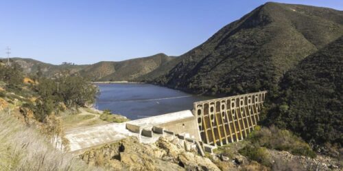
“With an El Niño winter threatening heavy rain, the State Auditor warns that California’s aging dams “continue to pose a risk to public safety,” especially in the Bay Area, San Diego, and Los Angeles areas. Lawmakers gave the state the power to penalize dam owners that violate safety requirements in 2017, after the Oroville spillway failure forced the evacuation of nearly 200,000 people. Water managers have yet to use that power, the audit found. Even if state water managers had wielded their enforcement powers, dam owners likely couldn’t have afforded the fixes. An audit released Monday found 57 dams in poor or unsatisfactory condition as of May, up from previous counts. That number is likely to keep rising, as state water officials reevaluate aging dams. The 40 riskiest dams — rated high or extremely high hazard — are located throughout the state, but cluster near densely populated coastal cities. Should these dams fail, the auditor reported, “they could collectively endanger as many as 1.5 million people and cause more than $265 billion in economic damage.” … ” Read more from Cal Matters.
SEE ALSO: California auditor gives damning assessment of state’s dams, from the Courthouse News Service
Achieving groundwater sustainability while preparing for El Niño
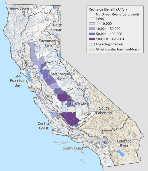 “California’s weather extremes are a reminder that managing our groundwater resources requires planning for both drought and floods. After a warm spring that rapidly melted the State’s snowpack, forecasts now point to strong El Niño conditions for this coming winter, bringing the potential for significant storms and opportunities to replenish groundwater supplies. Over the past six years, our state has experienced record-breaking weather events, from severe drought that strained domestic wells to historic precipitation that produced excess flood flows threatening life, property, and critical infrastructure. These extremes underscore the importance of building a more resilient water supply – one that can capture and store water during periods to help sustain communities, agriculture, and ecosystems through dry years. That work is already underway. Through the Sustainable Groundwater Management Act (SGMA), local agencies are making progress toward long-term groundwater sustainability, supported by state investments in groundwater recharge, improved monitoring, and coordination. As California prepares for a potentially wet winter, state and local partners are working together to identify opportunities to capture and store available flood flows when conditions allow. … ” Read more from DWR.
As the Super El Niño looms, California needs more natural infrastructure to buffer water extremes
“Meteorologists are forecasting a historically strong El Niño system this coming winter after a 2025 defined by prolonged drought and a weak snowpack, with a 95% chance of extreme precipitation. California sits on a climatic boundary where drought and deluge are recurring features of our hydrology, and unpredictability comes with the territory. Climate change is intensifying those swings. Increasingly, much of the water system we built over the last century was designed around an unreliable assumption: that the hydrology of the future will look much like the hydrology of the past. Some of our dams, levees, aqueducts, and reservoirs still serve a useful purpose. Others have outlived theirs. But for generations, we have treated built infrastructure as an asset while too often treating healthy rivers and watersheds as something separate from the systems that sustain our communities. … ” Read more from American Rivers.
The momentum is building for better water data in California: What comes next for the initiative to streamline water data reporting
“On September 3rd, 2026 more than 400 water professionals across the state joined us for the launch webinar of the Initiative to Streamline Water Data Reporting in California (ISWDR CA). We shared a lot of information that morning. We walked through our first comprehensive look at California’s water reporting landscape, discussed how reporting requirements have evolved over time, and showed some of the early analysis underway to better understand how information moves from local water agencies to the State. We were also grateful to be joined by E. Joaquin Esquivel, Chair of the State Water Resources Control Board, who opened the conversation with remarks about the importance of reliable water data to California’s future. His words helped set the tone for the discussion: better water data is not an end in itself—it is foundational to how California plans, manages its resources, and prepares for changing conditions. … ” Read more from the California Water Data Consortium.
SAFER Consolidation Explorer: An interactive tool for screening water system consolidation in the San Joaquin Valley
“Physical consolidation, which connects a smaller water system to a larger provider through new pipeline infrastructure, is the primary long-term solution promoted by state regulators. Sangha (2026) applied the State Water Resources Control Board’s 2024 screening methodology to 210 Failing and At-Risk water systems in Kern, Kings, Tulare and Fresno counties and identified 114 consolidation pairs. The SAFER Consolidation Explorer extends that analysis to all 794 water systems in the four counties, documenting the screening outcome for each system and allowing any pair of systems to be evaluated against the State criteria. It is intended for water system managers and boards, planners, technical assistance providers and community members. … ” Read more from UC Ag and Natural Resources.
Tide’s End Project will complete 10-mile wetland corridor in Yolo Bypass
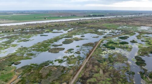
“A proposed restoration project at the southern end of the Yolo Bypass will connect existing wetlands while supporting agriculture and flood management. At the Delta Stewardship Council’s September meeting, Judah Grossman of the Department of Water Resources’ Division of Multi-Benefit Initiatives briefed council members on the ecological, flood-conveyance, and land-use benefits of the 2,212-acre Tide’s End Multi-Benefit Restoration Project. The proposed 2,212-acre Tide’s End multi-benefit restoration project is in Yolo County at the downstream end of the Yolo Bypass, about 12 miles southwest of Sacramento. Adjacent to the Cache Slough Complex and the Toe Drain along the west side of the Sacramento Deep Water Ship Channel, the site lies where the Yolo Bypass floodplain meets the Delta’s tidal influence, giving the project its name and contributing to its ecological importance. … ” Read more from Maven’s Notebook.
New NASA data shows why scientists struggle to model Western rivers
“New satellite observations show that some global river models struggle to account for dams, reservoirs and other human influences, raising questions about their reliability for water planning. A new NASA satellite is revealing major flaws in the computer models scientists use to understand rivers, including waterways across the American West. Researchers found serious modeling errors in nearly 10% of the river stretches they studied worldwide. But those errors often occurred in waterways that are especially important for managing water supplies, generating hydropower and preparing for climate change. The study, published in Geophysical Research Letters, compared global river models with observations from NASA’s Surface Water and Ocean Topography satellite. … ” Read more from KUNR.
AI’s water strain includes surging demand from electricity use
“Data center developers have started touting new technologies that slash the amount of water needed to cool hot-running servers in drought-stressed places like Arizona. Those efforts, though, are not addressing the vast majority of the water consumed by the AI buildout. Miles away from multiplying data centers, power plants are now consuming enormous volumes of water to generate the electricity required to run artificial intelligence, including those more efficient cooling systems. New research indicates that such indirect water consumption is rapidly growing. In a recent paper, University of Michigan researchers estimated water used offsite would boost the total annual consumption of three large AI data centers planned for the state by 14 billion gallons. “There has been much less attention to this indirect water usage, even though that oftentimes is significantly higher than the direct water usage and has impacts on watersheds and regional water resources,” said Shaolei Ren, a professor at the University of California at Riverside who studies data center water consumption. … ” Read more from Bloomberg.
Lithium mines leech water from surrounding communities. Soon, they’ll run dry
“A lithium deposit beneath the Salton Sea is bringing droves of mine developers to California’s Imperial County — and they may have a devastating impact on the county’s natural resources. Inside Climate News reports that lithium mines’ water demands, combined with the scarcity of water in Imperial County, may lead to water bill spikes for residents who already face high unemployment rates. There are about 100 proposed mining projects in the United States, two-thirds of which are adjacent to economically and socially vulnerable communities, according to an analysis by Columbia Journalism Investigations and Inside Climate News of demographic measures. Imperial County has greenlit two. … ” Read more from Planetizen.
California Forever: Solano County advances Collinsville zone change
“Solano County is moving ahead with its own zoning change for land near Collinsville that has been eyed for shipbuilding and maritime manufacturing, even as debate continues over California Forever’s proposal for development in the area. The county’s Department of Resource Management announced Tuesday that it is advancing a proposal to rezone approximately 1,312 acres east of Collinsville from Exclusive Agriculture to Industrial–Water Dependent, bringing the properties into alignment with the county’s 2008 General Plan. The announcement comes less than two months after the Solano County Board of Supervisors voted to delay taking a position on proposed state legislation intended to facilitate shipbuilding and maritime manufacturing at the site, effectively killing the effort for the last legislative session. That proposal, known as the Solano Maritime and Manufacturing Act, drew criticism from residents and environmental advocates concerned about the pace of the process and the potential effects of development. … ” Read more from the Vacaville Reporter.
Wide-scale cropland loss has consequences for wildfire resilience in the American West, new research finds
“The Western U.S. is facing parallel and escalating hazards in the form of ongoing drought and increasingly frequent wildfires. Although the region’s ecosystems have evolved with wildfires, the intensity and frequency of blazes where people live and recreate remains a persistent challenge for communities. New research examines tradeoffs in wildfire resilience when Western communities face hard decisions about adaptation strategies to drought, such as retiring or converting irrigated cropland. The question has widespread implications across the region, with more than 4 million hectares of cropland loss across the Western U.S. over the last 40 years. The research, published October 12th in the journal Environmental Research Letters, was co-led by Austen Lorenz and DRI’s Bea Gordon alongside colleagues including fire managers. They examined wildfire perimeter data for nearly 10,000 fires from 1985 to 2024 to create the first regional assessment of cropland’s association with where wildfires stop. The study’s results found that cropland serves as a landscape-scale buffer to wildfire as demonstrated across 11 Western states. When compared to other land uses like wildlands, urban communities, and forests, cropland is simply less likely to end up inside a wildfire burn scar. The research has implications for improving management of both water saving strategies and wildfire risk reduction, which the authors suggest should be managed jointly, rather than in isolation. … ” Read more from the Desert Research Institute.
SEE ALSO: Vanishing Farmland Leaves the American West More Exposed to Wildfire, from Science Magazine
In regional water news and commentary today …
NORTH COAST
Wind‑driven waves hit Humboldt Bay Trail, raising winter concerns
“Strong winds sent waves crashing into the edge of the Humboldt Bay Trail on Saturday, splashing water across the trail into the newly built overwash zone beyond the path. The surge caught cyclists off guard and offered an early look at how the corridor may perform heading into a winter expected to bring King Tides, El Niño conditions, and elevated sea levels. The trail, completed this year, was designed to withstand occasional flooding. But the waves that rolled across the pavement Saturday were forceful enough to send cyclists hugging the inland edge of the path, trying to maneuver around spray and sheets of water washing over it. Jen Kalt, executive director of Humboldt Waterkeeper, happened to be driving southbound on 101 when she witnessed the waves splashing over the barrier toward the trail. “When I saw it, I was driving by, and I was like, ‘Whoa!’ And I saw some people on bikes dodging the waves and stuff. I mean, it was in multiple spots too,” said Kalt. “It was really windy, and the wind was blowing the waves straight against the shoreline there.” … ” Read more from the Eureka Times-Standard.
SIERRA NEVADA
‘We’re weather farmers’: Will Tahoe see a big winter in El Niño?
“The high peaks of the Sierra Nevada saw a dusting of snow this week. Mt. Rose Ski Tahoe is leveraging cold nights and crisp mornings to make its own snow. As days become shorter, stacks of firewood are piled high and neat alongside mountain homes. It’s the peak of fall in the Sierra Nevada, and among skiers and snowboarders, the topic of conversation has decidedly shifted to the upcoming winter. Everyone wants to know: Will El Niño deliver? This year, with a mega El Niño brewing, the hype for a big winter seems to be keeping pace with the rising sea surface temperatures in the Pacific. Chances are high for a “historic” El Niño that would be larger than anything seen since 1950, according to an outlook published last week by the National Weather Service’s Climate Prediction Center. This El Niño is already on par with the strongest El Niños on record, and sea surface temperatures are predicted to continue rising. … ” Read more from SF Gate.
Tahoe ski area plans to open in less than a month
“One of Tahoe’s highest-elevation ski areas, Mt. Rose, is already making snow with the intention to be the first resort in the region to open for skiing. With a base elevation of 8,260 feet and a substantial snowmaking system, the family-owned ski area just outside Reno is often the first in Tahoe to start spinning its chairlifts. This week, Mt. Rose announced that temperatures are cold enough to enable it to begin blanketing its slopes with artificially made snow. The ski area plans to open Nov. 6, much earlier than most of Tahoe’s premier resorts, which plan to open around Thanksgiving. … ” Read more from the San Francisco Chronicle.
SACRAMENTO VALLEY
Gridley: Groundwater holds steady despite dry years
“Groundwater supplies across the Butte Subbasin have remained stable despite two dry years that increased pumping demands, according to findings approved Oct. 5 by the Gridley City Council. The evaluation covers 2021 through 2025 and found no significant problems threatening groundwater sustainability. City Administrator Elisa Arteaga said the findings indicate water levels showed little change, groundwater storage showed signs of recovery by 2025, and monitoring found no significant land subsidence, or sinking of the ground. Groundwater officials said the findings reflect how the region manages its water supplies. During wetter years, agriculture relies heavily on surface water from the Feather River, Sacramento River and Butte Creek. When those supplies decline, groundwater helps make up the difference, they said. … ” Read more from the Gridley Herald.
Yolo County agriculture topped $911 million in 2025 as almond values surged
“Fueled by surging almond and pistachio production, Yolo County’s agricultural industry generated $911.9 million in 2025, an increase of nearly $93 million, or 11.3%, from the previous year, even as the region’s struggling wine grape industry continued to lose ground. Yolo County’s 2025 Crop and Livestock Report showed that ag production reached its highest value in at least six years, driven largely by gains in almonds and other fruit and nut crops. The county also issued agricultural export certificates for shipments to 102 countries. The report was presented to the Yolo County Board of Supervisors on Oct. 6 by Agricultural Commissioner Humberto Izquierdo. The figures measured the gross value of ag production, not farm profits or the industry’s broader economic impact. The report also noted that rising production costs offset some of the gains. … ” Read more from the Sacramento Bee.
BAY AREA
Bay Area braces for record-breaking El Niño
“As El Niño has taken hold in the Pacific, a blob of water has sloshed across the ocean and toward the west coast of the Americas. This mass of water, called a Kelvin wave, will raise Bay Area sea levels up to 12 inches this October. While Kelvin waves are a classic harbinger of the global climate event, this winter’s waves mark the arrival of a very unusual El Niño. The National Weather Service announced an 83% chance this winter’s El Niño will be the strongest since records began in 1950. Citing the possibility of supercharged storms and elevated sea levels, California Gov. Gavin Newsom last month declared a State of Emergency to prepare for potentially catastrophic flooding. The risk is especially acute on the coast, where atmospheric rivers, sea level rise, Kelvin waves, and other weather events can converge to erode beaches and inundate communities. Local governments in flood-prone areas have spent months meticulously planning for a potentially unprecedented winter. While no human alive today has ever seen an El Niño of this intensity before, scientists warn this winter is just a preview of a much warmer future. … ” Read more from Knee Deep Times.
A major North Bay highway is set to shut down to prepare for El Niño. Here’s when
“A major North Bay highway is set to close for three days next weekend as workers scramble to spare it from flooding. Highway 37, the scenic and notoriously dysfunctional commuter route from Interstate 80 in Vallejo to the Highway 101 junction in Novato, is the only Bay Area infrastructure on Gov. Gavin Newsom’s list of 21 El Niño emergency projects. State transportation officials are working to plan and fund an ambitious overhaul of the 21-mile stretch, which gets swamped by storm water each winter and is in danger of sinking into the bay by 2050. But next week’s 55-hour closure will address a more immediate problem on the eastern section of 37 from Mare Island to Sears Point, said Caltrans spokesperson Bart Ney. Over summer, high tides started eroding the shoreline and the embankment beneath the highway, creating perilous conditions for passing cars. … ” Read more from the San Francisco Chronicle.
San Jose leaders zero in on flood risks amid strong El Niño
“As a strong El Niño season heightens flood risks throughout California, some in San Jose are raising the alarm that shaky coordination between South Bay government agencies could hamstring emergency preparation efforts. During a Tuesday joint meeting between the Valley Water board of directors and San Jose City Council, a chorus of officials and residents warned that fuzzy jurisdictional boundaries often make it unclear who is responsible for dealing with floods risks when they arise along San Jose’s 140 miles of waterways. The tangled lines of authority have generated frustration from residents who fear such confusion will lead to delays in flood mitigation work — such as clearing debris like garbage or fallen trees — that could prove catastrophic should El Niño trigger heavy rains this winter, as weather forecasting suggests is likely. “I think it’s important that we keep in mind that when our residents, our shared constituents look into the waterways and see a fallen tree or a blockage … they shouldn’t have to think about the jurisdictional boundaries between our agencies,” San Jose Mayor Matt Mahan said during the meeting. “They just see a problem, and they want a solution, and they expect us to deliver it.” … ” Read more from the San Jose Spotlight.
CENTRAL COAST
UC Santa Cruz study finds new method to predict domoic acid outbreaks
“Domoic acid may have been the culprit behind an unusually high number of sea lion strandings on the Monterey Bay coast over the summer. The neurotoxin can affect marine mammals, birds and even humans, but outbreaks are difficult to predict. Now, researchers from UC Santa Cruz have pioneered a new detection method that could give weeks of notice before domoic acid becomes dangerous to humans. The research team’s study on the method was published Sept. 30 in the Proceedings of the National Academy of Sciences. “This method gives us a much bigger window of time,” said Raphael Kudela, a distinguished professor at UCSC and senior author of the study. “We could tell you six weeks in advance, potentially … A much more early warning than you get using our other methods.” … ” Read more from the Monterey Herald.
SAN JOAQUIN VALLEY
Friant-Kern Canal begins US$200 million modernization
“The US Bureau of Reclamation and the Friant Water Authority have started work on Phase 1 of the Friant-Kern Canal Pump Station Replacement Project in California. The initiative aims to modernize a key conveyance system and make water supplies more dependable for the farms, businesses and communities of the San Joaquin Valley that rely on it. Completed in 1951 as part of the Central Valley Project, the 152-mile (245 km) canal carries water from Millerton Lake, a reservoir on the San Joaquin River near Fresno, south to the Kern River in Bakersfield, serving users in Kern, Tulare, Fresno and Kings counties. The Department of the Interior has allocated $200 million to the upgrades. Reclamation describes the project as one of California’s largest conveyance modernization efforts. It follows the agency’s Middle Reach Capacity Correction Project, finished in spring 2024 to address capacity losses caused by land subsidence, as groundwater was pumped faster than aquifers could recharge. … ” Read more from Smart Water Magazine.
SOUTHERN CALIFORNIA
Metropolitan board of directors elects Martin Miller as new board chair
 “Longtime water professional and businessman Martin “Marty” Miller was unanimously elected today to be the next chair of the board of directors of the Metropolitan Water District of Southern California, the largest supplier of treated water in the country. Miller, who has represented the San Diego County Water Authority on Metropolitan’s 38-member board since 2021, will serve a two-year term beginning Jan. 1. He is the first representative from San Diego to lead Metropolitan’s board in its nearly 100-year history. He succeeds outgoing Chair Adán Ortega, Jr., who has led the board since 2022. “I am grateful to my colleagues for placing their trust in my leadership for the next two years,” Chair-elect Miller said. “Our board faces some important decisions ahead on how to invest in our region’s long-term water supply reliability, while balancing concerns about the affordability of water. I am committed to working with my colleagues to produce smart solutions that benefit cities and communities across Southern California” … ” Read more from the Metropolitan Water District.
Santa Ana winds, critical fire danger on tap for Southern California
“Although high surf continued to present a concern in some coastal areas Tuesday attention was beginning to turn to an anticipated onset of Santa Ana winds expected to drive up temperatures and fire danger in Southern California beginning as early as Wednesday, Oct. 14. Powerful waves that have devastated coastal areas in Long Beach and Orange County over the past several days — the aftermath of former Tropical Storm Rachel — were slowly beginning to diminish, although surf remained treacherous Tuesday morning and hazardous conditions were expected to linger for another couple days. A beach hazards statement will be in effect at all Los Angeles County beaches through Thursday afternoon, indicating the presence of dangerous rip currents and elevated surf, along with some possible coastal flooding. Orange County will also experience some high surf, with expectations for 3- to 6-foot waves through Thursday, according to National Weather Service meteorologist Stephanie Sullivan. The waves will likely escalate again early next week in the coastal areas. … ” Read more from the LA Daily News.
IMPERIAL/COACHELLA VALLEYS
IID crews swiftly repair Westside Main Canal breach following heavy storm runoff
“Imperial Irrigation District crews repaired a breach along the Westside Main Canal on Sunday after a surge of stormwater from the surrounding desert overwhelmed the canal, sending more water into the channel than it was designed to carry. The breach followed heavy rainfall associated with Hurricane Rachel, which sent floodwaters rushing through desert washes and into the canal running along the western edge of Imperial Valley. IID had begun preparing for the storm the day before. On Saturday, October 10, the District reduced flows into the Westside Main Canal from a normal average of approximately 720 cubic feet per second to 140 cubic feet per second. By 6 a.m. Sunday, IID had completely shut off flows into the canal. Despite those precautions, stormwater continued pouring into the canal from the Yuha and Coyote desert washes. The runoff exceeded 3,200 cubic feet per second, surpassing the canal’s maximum capacity of approximately 2,200 cubic feet per second. … ” Read more from the Imperial Irrigation District.
Along the Colorado River …
Colorado River drought drives unprecedented pattern of groundwater loss
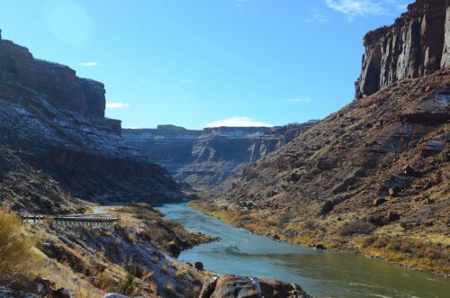 “Declining Colorado River flows and falling water levels at Lake Powell and Lake Mead are highly visible signs of the Southwestern megadrought. Unseen below ground, groundwater reserves in the Colorado River Basin are disappearing just as fast — and in an unexpected new pattern, according to research from Virginia Tech. Historically, groundwater has declined more in the Lower Basin. But the system has hit a turning point: The Upper Basin is now experiencing rapid groundwater losses, with surface-water shortages increasingly affecting groundwater as well. To isolate changes in groundwater stocks across both basins, Virginia Tech’s Susanna Werth and a team of geoscientists combined measurements from NASA’s Gravity Recovery and Climate Experiment satellite mission with estimates of surface water, soil moisture, and snow-water storage from 2004 to 2023. Their findings were published in Water Resources Research. Results point to an acceleration in groundwater depletion after 2019. During the severe drought from 2020 to 2022, the Upper Basin lost about 4.6 trillion gallons of groundwater. This was nearly double the loss in the Lower Basin, which was estimated at 2.5 trillion gallons. … ” Read more from Virginia Tech.
SEE ALSO: Colorado River Megadrought Now Drains Hidden Groundwater in an Unexpected Place, from Science Magazine
The Colorado River crunch: How water scarcity could reshape housing growth across the West
 “For decades, the Colorado River helped fuel the rise of some of the nation’s fastest-growing housing markets. Today, however, a combination of long-term drought, population growth, and aging water allocation agreements is forcing policymakers, utilities, developers, and builders to rethink assumptions about future growth across the Southwest. At the center of the challenge is a simple imbalance: demand for Colorado River water has outpaced the river’s long-term supply. The system was originally governed by agreements developed more than a century ago, based on flow estimates that are now widely viewed as overly optimistic. Since then, major metropolitan areas across Arizona, Nevada, and Southern California have expanded dramatically while the river has experienced a prolonged period of drought beginning in the early 2000s. The result has been a significant decline in storage levels at Lake Mead and Lake Powell, two reservoirs that are critical to both water delivery and hydropower production throughout the region. Federal officials have increasingly intervened to stabilize reservoir levels and protect the infrastructure that supports millions of residents and businesses, most recently outlining the largest mandatory usage cuts in the river system’s history. … ” Read more from Builder.
Rain, strong El Niño offers hope for Arizona drought relief
“Arizona finished this year’s monsoon with above-average precipitation in many parts of the state, following two years of below-average monsoon rain and mountain snowpack. Forecasters are now watching a strong El Niño pattern that could bring snow to the state’s high country this winter. In Flagstaff, soil remained saturated this week from weekend rainfall. Hydrologists say the moisture helps the state’s water supply and prepares the water system to retain more water this winter. Arizona has been in a long-term drought for decades, and the past few years have been especially dry, raising concerns about the state’s limited water supply. … ” Read more from Arizona Family.
A rare Arizona meadow protects the Valley’s water supply
“When most people picture Arizona, they imagine towering saguaros, rocky mountains and miles of desert. But about 100 miles northeast of Phoenix, tucked away in the Tonto National Forest near Payson, there’s a landscape that looks almost out of place. A lush, green meadow, with water just beneath the surface. It’s known as the Little Green Valley Fen, and according to the U.S. Forest Service, it’s one of only two known wet meadows of its particular kind in Arizona. “This is a very unique system because it’s wet and it’s wet year round,” said Kelly Mott Lacroix with the Tonto National Forest. … ” Read more from Channel 15.
Arizona’s water providers are preparing today to protect our water tomorrow
Doug Denham, water resources director at EPCOR, writes, “With federal cuts reducing Arizona’s Colorado River allocation by 27 percent each year through 2028, many people are coming to us concerned and asking: “Will I still have water?” “Will my tap run dry?” “What should we do?” The short answer is that Arizona faces serious long-term water challenges, but these cuts do not mean customers should expect their taps to suddenly run dry. Utility providers have been banking water, diversifying supply portfolios, modeling shortage scenarios and developing ways to shift water sources as conditions change. At EPCOR, we have been proactively planning for shortages for more than a decade by working to reduce our use of Colorado River supplies while using stored water and other resources to protect customer reliability. … ” Read more from the Arizona Free Press.
Scottsdale water well conversion project
“Scottsdale Water is preparing to begin construction to convert the existing PG-41 groundwater monitoring well along Cattletrack Road into a production well that will become part of Scottsdale’s drinking water system. PG-41 is located within an area associated with the North Indian Bend Wash Superfund site. The project is being funded by potentially responsible parties associated with the Superfund site; the city of Scottsdale is not responsible for the project’s construction costs. Once the conversion is complete, water pumped from the PG-41 well will first be treated at the nearby North Indian Bend Wash Granular Activated Carbon Treatment Facility, where granular activated carbon is used to remove contaminants. The treated water will then be conveyed to the Chaparral Water Treatment Facility, where it will be blended with other water sources before entering Scottsdale’s drinking water distribution system. … ” Read more from Signals AZ.
Commentary: Nevada is right to sue over its newly curbed Colorado River allocation
Gary Wockner, director of Save The Colorado, writes, “Nevada did something recently that the rest of the Colorado River Basin should have seen coming: It sued the federal government. Along with the Colorado River Commission of Nevada and the Southern Nevada Water Authority, the state challenged the Department of the Interior’s new record of decision governing operations at lakes Mead and Powell. Save The Colorado, our program dedicated to protecting this river, publicly supports that lawsuit, and we’re considering filing an amicus brief in the case. Here’s why. Under the plan, Nevada could lose more than 70 percent of its already tiny Colorado River allocation — a state that only gets 300,000 acre-feet a year to begin with, the smallest slice of any basin state. Meanwhile, the four Upper Basin states — Colorado, Utah, New Mexico and Wyoming — face no mandatory cuts at all, only voluntary conservation goals that history shows rarely amount to much. That imbalance would be easier to stomach if Nevada were a water hog, but it isn’t. … ” Read more from the Nevada Independent.
Moab’s Colorado River trips will have to adjust after a live zebra mussel turns up above town
“The pipe-clogging zebra mussel has turned up in the Colorado River above Moab, and the state says the way people run the river from the Colorado line to Lake Powell will have to change. State biologists pulled a single live adult from the river below the Westwater Recreation Area on Sept. 22, the Utah Division of Wildlife Resources said in an Oct. 8 news release. Lab tests confirmed it on Oct. 7. Until then, the only sign of zebra mussels on the Utah side of the river had been their DNA in water samples. So far, that one mussel is all crews have found: no others, no more mussel DNA and no larvae, Lt. Bruce Johnson, the Utah Department of Natural Resources law enforcement lieutenant over statewide aquatic invasive species operations, told the Moab Sun News in an Oct. 12 email. … ” Read more from the Moab Sun.
As Lake Powell dries up, mud threatens its future
““Don’t stand behind me,” says Cari Johnson, as she digs a small gardening hoe into a steep slope above the Colorado River in Utah’s remote Cataract Canyon in an attempt to climb. “This is all loose.” Her warning is well-founded. As the University of Utah geology professor places one foot on her newly carved step, it gives way underneath her. “This one’s coming down,” she shouts as a basketball-sized clay boulder begins to tumble, sending up plumes of fine dust. This slope is not made of the hardened sandstone that forms the towering cliffs of the surrounding desert canyon. Johnson is studying an unstable Frankenstein’s monster composite—made up of loose sand, fine silt, cobblestone, mudstone, and clay. Much like traversing on top of an icy glacier, one wrong step on what appears to be stable ground can prove disastrous, collapsing down into steep gullies or hidden crevasses. The material is so perilous because 10 years ago, in this very spot, we would have been standing at the bottom of Lake Powell, the nation’s second-largest reservoir. … ” Read more from National Geographic.
Momentum for measuring water lost in Wyoming’s portion of the Colorado River dries up
“Wyoming has shelved a state-funded project to measure water use in the Green River and Little Snake River basins after it could not get enough data to create a basin-wide estimate of water lost during irrigation. At a meeting in the Cowboy State capitol of Cheyenne last month, members of the Wyoming Water Development Commission (WWDC) reported that difficulty gaining access to landowners’ ditches coupled with unexpected costs prevented the contractor from securing access to all 20 irrigation ditches the company planned to survey. With only 12 ditches measured, the company’s data did not produce “statistical significance for larger basin characterization,” said Chace Tavelli, the project’s manager with the Wyoming Water Development Office. “All data is good data to have,” he added. “We learned about challenges, and there are some ditches that appear to have information that could be very valuable.” … ” Read more from Inside Climate News.
In national water news today …
“Forever chemicals” pollute more than 80% of tested US waterways
“If you swam, fished or paddled a lake or river in the US over the past couple of years, there’s a more than 80% chance the water contained toxic “forever chemicals,” according to a new report. The report, published today by Environment America Research & Policy Center, found hotspots for the toxics, including the Mississippi River and Lake Ontario, and warns that this widespread pollution is likely “just the tip of the iceberg,” as it represents only a sampling of US waterways tested for per- and polyfluoroalkyl substances (PFAS). “The report underscores what is really a much bigger problem than what most people realize,” said Tony Spaniola, co-chair of the Great Lakes PFAS Action Network. “If anything, the report dramatically understates the problem.” … ” Read more from The New Lede.
‘Chemically active’ microplastics can react to water and human blood
“It took less than twenty years for microplastics to go from scientific mystery to internet meme. Many people now simply accept the idea that consuming everyday food and liquid items causes the ingestion of nearly undetectable, particle-sized plastic fragments. But what happens to these fragments after going down the hatch is less known. Researchers in a study published Wednesday in the journal Nature indicate that microplastics don’t stay dormant, instead chemically reacting to water — which makes up the majority of human blood — in ways that can harm organic life. They say nanoplastic presence in the human bloodstream could be even more harmful than previously thought. “Our research found that when microplastics interact with water, as they do when they’re in bottled water, or when they’re absorbed into our bloodstream, they spontaneously generate what we call reactive oxygen species … textbook examples of the kinds of molecules that can damage animal and human tissue,” study co-author Naixin Qian said in a statement. … ” Read more from the Courthouse News Service.