
Several news sources featured in the Daily Digest may limit the number of articles you can access without a subscription. However, gift articles and open-access links are provided when available. For more open access California water news articles, explore the main page at MavensNotebook.com.
In California water news today …
‘A potential catastrophe’: Sacramento-San Joaquin Delta prepares for Super El Niño
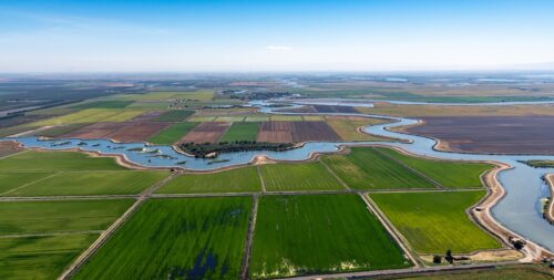
“Aaron Lickingteller pointed down from the top of one of the westernmost levees in the Sacramento-San Joaquin Delta to the land 25 feet below. Without constant maintenance work, he said, these levees degrade quickly. “Squirrel holes, dead trees, little leaks, a little bit of erosion. Next thing you know, you’re springing a leak,” he said. “That leak is like a zipper on a pair of pants. You just unzip that, and everything comes out, you know what I mean, or goes in.” Like most Delta islands, Twitchell Island sits below sea level. It is less of an island, more of a bowl. On either side run the Sacramento and San Joaquin rivers, which together capture about 40% of the state’s runoff. This year, as California faces what experts are calling “Super El Niño” conditions, residents in the Delta are preparing for the prospect of devastating flooding. But they have faced tough conditions before, and while they are reading for worst-case scenarios, some feel a hard-earned confidence that comes from decades of work to improve levees and response systems. But if predictions hold, keeping the water out won’t be an easy task. The volume of water pushing against the Delta’s roughly 1,100 miles of levees — many built by hand more than a hundred years ago — will be much higher. … ” Read more from KQED.
El Niño, already near/at record intensity, will further strengthen to historic level and likely bring major California & SW U.S. winter impacts
Dr. Daniel Swain writes, “An El Niño event officially developed in the tropical Pacific Ocean earlier this summer, and it has strengthened almost continually since that point. In fact, as of mid-October, the 2026 El Niño event has already become the strongest on record by almost any metric. … These numbers remarkable in their own right, but even more notable is that they were foreseen months in advance–by many predictive models, as early as mid-spring. I started talking about the (uncertain) potential for a big event in April, then wrote a special Weather West report in June as confidence jumped considerably, and have subsequently been offering dedicated monthly video briefings. We often talk about the Spring Predictability Barrier–a window around May/June prior to which reliable ENSO predictions have historically been difficult due to complex Earth system feedbacks–but this year nearly all major predictive models latched on to a very strong ENSO signal quite early, stuck with it, and (as of October) have now been largely validated. … ” Read the full post at Weather West.
The phenomenon that could blunt El Niño
“Twenty-eight years ago, Saturday Night Live cut to “satellite imagery” of the tropical storm threatening the Pacific Coastline: It was Chris Farley dressed as a pro wrestler named El Niño. The 1997 El Niño threatened to bring Southern California one of its worst winters in history, according to a Los Angeles Times article published days before the SNL sketch. Sound familiar? El Niño, and its sister phase called La Niña, is basically a big switch in the conditions of the ocean and the atmosphere around the tropical Pacific Ocean with global weather implications. And everybody is really worried about it right now, again. … But there’s one very large difference between the super El Niño of 1997 and the super El Niño of 2026. And it’s not that Farley is no longer with us — RIP. Enter another important climate pattern called the Pacific Decadal Oscillation, or PDO. The PDO is also a shift in Pacific Ocean temperatures but more between the northern and southern hemispheres. It also occurs over much longer timescales. El Niño can switch to La Niña in a period of a few years. The PDO lasts decades as its name suggests. Since 2020, the PDO has been in a “cooling” phase. And that should be good news. … ” Read more from the Voice of San Diego.
With El Niño on the horizon, DWR prepares the flood system
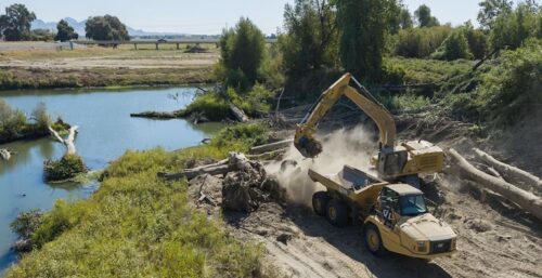 “In the summer of 2022, California was in the middle of the driest three-year stretch on record. But that fall, just as they do every year, DWR staff and local flood agencies fanned out across the Central Valley to prepare its complex system of flood bypasses, weirs, canals and other infrastructure for the possibility of high water. Crews performed critical maintenance and repairs, cleared vegetation, and readied the flood system, even as the landscape around them remained dry. That work is carried out year after year by DWR and its partner agencies responsible for maintaining the State Plan of Flood Control, the integrated state-federal flood management system that protects over 2 million Californians across the Central Valley. Just months later, that preparation proved critical. Throughout the winter and spring of 2023, high water spilled into the Sutter and Yolo bypasses as a series of powerful storms swept across California, putting the system to the test. The Sierra Nevada received one of the largest snowpacks in state history, keeping Central Valley rivers elevated well into the summer. Some locations on the Sacramento and San Joaquin rivers remained at flood stage in late June. … ” Read more from DWR.
New California law cuts red tape to stop golden mussel invasion. Next, action shifts to Congress
“California lawmakers have already made a decisive move in the battle against golden mussels, the tiny bivalves that are clogging waterways and pipes in the Delta. But it’s a waiting game in Congress. There, the race is on to see whether measures to control the invasive species can be enacted before the end of the legislative year. First detected two years ago in the Port of Stockton, golden mussels multiply by the millions and have spread across inland waterways throughout the state. They clog water system intakes, irrigation valves, and boat hulls and engine cooling inlets. The aquatic pests are believed to have hitchhiked to inland California in the ballast water of a ship from Asia, where they are common. When it comes to legislative battles to try to stop them, there’s been one recent major victory. … ” Read more from Stocktonia.
Bay Delta Plan threatens Klamath salmon restoration, tribes, advocates say
“Just two years after the removal of the last dam on the Klamath River, a new water management plan could threaten hard-won salmon restoration efforts and tribal water rights in Northern California. Tribes and environmental advocates warn that California Gov.Gavin Newsom’s Bay-Delta Plan could divert water from the Trinity River, the Klamath’s largest tributary, into the Central Valley for agriculture. Those diversions could reduce the cold-water flows that help control the water temperature and protect salmon. The threat comes from 300 miles away in the Bay-Delta, where the Sacramento and San Joaquin rivers converge into San Francisco Bay and where Newsom is proposing major changes to water management rules to allow for greater flexibility in water use for cities and farms while protecting native species. Advocates say the plan, along with Newsom’s recent veto of a critical water rights bill, puts the Klamath Basin at risk. “People don’t realize that all of those decisions in the Central Valley on water decisions do impact the Klamath through the Trinity River and these water releases for salmon,” Regina Chichizola of Communities United for Water Protection told Native News Online. … ” Read more from Native News Online.
Getting under the skin of salmon science
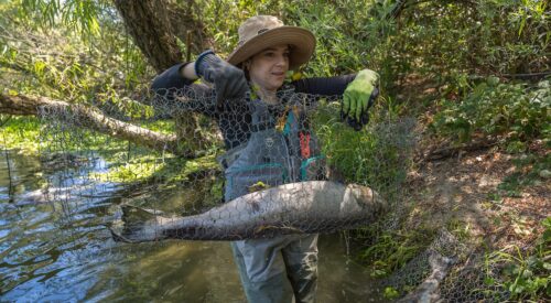
Nick Shockey / DWR
“This is not a job for the squeamish or faint-hearted, but the goals of science are not always clean and neat. The job? Pulling Chinook salmon carcasses from the water, onto a boat, and performing an open-air autopsy of sorts to answer important questions about the iconic fish. DWR senior environmental scientist Michelle Pepping did just that on the Feather River. Under a bright sun, she sampled decaying salmon carcasses in the summer heat. It’s part of a unique study to identify which salmon tissues provide the best DNA. “By identifying better tissue types for DNA sequencing, we are increasing the information for many groups,” she said. “This information is used for university research, management decisions, and regular monitoring of our salmon.” … ” Continue reading from DWR.
The opportunity of change at the 2026 Bay-Delta Science Conference
“This year’s Bay-Delta Science Conference (BDSC) was a busy three days full of talks, posters, and discussions centered on the ecosystems that make up the heart of California. The San Francisco Bay and the Sacramento-San Joaquin Delta (Delta) are part of a region with a long history characterized by drastic change. River deltas call to mind the ancient civilizations of the Nile Delta and the biodiversity supported in the Okavango Delta. Historically, the Bay-Delta also supported high levels of biodiversity, large animal herds, and sizable human populations. Many of the conversations at BDSC this year focused on the loss of this legacy, a shared love for these ecosystems, recent scientific and management advances, and the future of this region. … ” Read more from FishBio.
A ‘charismatic landform’ is being lost in California
“A quarter of the glaciers in the contiguous United States have disappeared since the mid-20th century while the total area and volume of glaciers has dropped by about a third — and even more in California — a new study shows. The research, published Monday in the Proceedings of the National Academy of Sciences, is a particularly comprehensive assessment of the bleak state of glaciers and a stark indictment of climate change. Glacial melting in the Lower 48 states, a product of warming temperatures, is most severe in the Sierra Nevada and parts of the Rockies, the study suggests, due to warmer, drier conditions and glaciers that are generally smaller and less resilient. In the Sierra, where such ice sheets as the Palisade Glacier and Yosemite’s Lyell Glacier are hanging on after enduring for thousands of years, the number of glaciers has fallen from 94 to 64 since the 1970s, the study finds. Total glacial area in the range has decreased 64% over the period while glacial volume has fallen 77%. … ” Read more from the San Francisco Chronicle.
Fewer buyers for timber on federal land raises risk of wildfires
“When the U.S. Forest Service opened 947 acres in a remote section of western Colorado to commercial logging in July, officials expected at least a few companies to jump at the opportunity. Not one did. None had bid a year earlier, either. Surging fuel costs and plummeting prices for Ponderosa pine made it impossible for them to turn a profit from the sale, so they all skipped it. That isn’t just a problem for the loggers. Timber sales are an important tool for preventing catastrophic wildfires, helping to thin dense underbrush and other vegetation that builds up over decades. President Trump has taken steps to promote the American timber industry, increasing access for logging companies to federal lands and deploying executive orders and tariffs to boost their competitiveness. Yet loggers are passing up on timber sales across federal lands because of an accelerating downturn in the industry. Demand has been cratering for some wood products, especially pulpwood used to make paper. “It doesn’t matter what wood is available for sale if we don’t have a viable economic market,” said Scott Dane, executive director of the American Loggers Council. “Without markets, there is no forest management.” … ” Read more from the New York Times.
In commentary today …
Data centers consume like cities. They should contribute like cities as well
Dean Florez, a former California Senate majority leader, writes, “California has always hidden the true price of progress somewhere beyond the horizon. The water arrives from a distant river. The electricity crosses a mountain range. By the time the benefits reach us, the damage has been assigned elsewhere. Now the future is arriving in windowless buildings. Data centers are rising from industrial corridors and farmland with the appetite of cities. They pull electricity by the hundreds of megawatts. Inside, servers build fortunes. Outside, residents open their utility bills and wonder what will remain. Before California approves another facility, every host community deserves an answer: What will this project make better here? … ” Read more from the LA Times.
Permitting reform bill attacks 4 pillars of environmental protection
Chris Shutes with the California Sportfishing Protection Alliance writes, “On September 30, 2026, several senators from both major parties rolled out a 417-page piece of legislation that if passed would change the national landscape of environmental protection. The bill contains major rollbacks of protections in the Clean Water Act, the Endangered Species Act, the Federal Power Act, and the National Environmental Policy Act. The bill is entitled the “Bipartisan American Affordability and Jobs Act of 2026“. Its purported overarching purpose is to expedite construction of major energy infrastructure, in particular pipelines and electric transmission. Much of the impetus for the bill is projected energy demand for new Artificial Intelligence data centers. One of the present major bottlenecks for the construction and new energy projects is the current federal administration’s executive rescission and defunding of planned renewable energy projects. This bill would partially solve this real but temporary problem by preventing some rescission of energy projects by the executive branch. In exchange, this bill would permanently weaken a suite of foundational environmental laws. … ” Read more from the California Sportfishing Protection Alliance.
In regional water news and commentary today …
NORTH COAST
Chinook salmon return to historical habitat following removal of four US dams
“The Klamath River in the U.S. was heavily dammed over the 20th century, blocking spawning Chinook salmon. As a result, the population of salmon that spawned in the river, which runs through Southern Oregon and Northern California, declined by roughly 90%. However, a recent study found that removing the dams resulted in a quick return of the fish to the river. In 2024, four dams were removed from the Klamath, allowing Chinook salmon (Oncorhynchus tshawytscha) to recolonize habitat that had been unavailable to them for roughly a century. Shortly after the dams were removed, 7,742 Chinook salmon migrated up the Klamath River past the former dams. In 2025, that number jumped to more than 13,000. The fish expanded into 345 kilometers (214 miles) of formerly blocked river, recolonizing 88% of their known historical habitat, the study found. First author of the study Damon Goodman told Mongabay in an email that they expected the Chinook to return to the river but didn’t know how long it would take. “What surprised us was the speed and scale of their response – it felt like we were running to keep up with the fish! These fish navigated challenging rapids, engineered fishways, and a large lake to reach habitats that had been inaccessible for more than a century.” … ” Read more from Mongabay.
SIERRA NEVADA
Tahoe gets its first snow of the season as tropical storm Rachel’s leftovers reach the Sierra
“The calendar says mid-October, but the slopes in South Lake Tahoe looked a lot more like December on Monday morning, when the first snowfall of the season left a light white coating across parts of the resort. Resorts picked up measurable snow early Monday as light flurries fell across the higher elevations of the Sierra. Videos of flakes coming down were all over social media, and forecasters noted that flurries had already been spotted on the highest peaks on Sunday. Monday’s snow has an unusual origin story for the Sierra, since the moisture behind it came from the tropics. Leftovers from Tropical Storm Rachel, the same system that drenched Southern California over the weekend, wrapped north into the mountains and fell as snow above roughly 6,500 feet. … ” Read more from Active NorCal.
A Tahoe-area ski resort is preparing for winter as the weather finally cools
“As temperatures dropped for the first time this fall, one Lake Tahoe-area ski resort started working on its winter coat Monday. Mt. Rose Ski Tahoe, in New Washoe City, Nevada, fired up its snowmaking machines for the 2026-27 ski season Monday as temperatures at the Sierra Nevada resort fell low enough to make snow. It was the first of the area’s ski resorts to begin making snow, according to a news release from the resort. The ski resort said in its release that its base elevation of 8,260 feet — the highest among Lake Tahoe ski resorts — and mostly north- and east-facing slopes helped its “robust snowmaking system” take full advantage of the below-freezing, low-humidity conditions early Monday. “It’s always exciting to see the first taste of winter, and as an added bonus, to be able to crank out snowmaking in force over the next couple of days,” said Mt. Rose marketing director Mike Pierce in the news release. “We plan to make as much snow as possible with this latest cold snap and then be ready for all future opportunities to crank up the system.” … ” Read more from the Sacramento Bee.
SACRAMENTO VALLEY
Butte County avoided major wildfires this summer, officials say fire danger isn’t over
“Butte County dodged a major wildfire summer, but with vegetation still “very dry” and temperatures staying warm in October, fire officials said residents shouldn’t let their guard down. Cal Fire-Butte County Public Information Officer Chelsea Burkett said Cal Fire as a whole describes a year as fire years instead of looking at fire seasons, which many people have been accustomed to. She added that while the summer was relatively quiet, there were still many smaller fires that were able to be put out with minimal damage. She said that a growing pattern in the last several decades has been “peaks and valleys” of fires, with some stretches of years having many large fires, and then the next stretch having fewer. However, she said that it’s still early to tell, with many of the largest fires happening in later months. “Here in Butte County, we’ve seen a lot of smaller fire fires, but we’ve been able to quickly respond to the fires and mitigate them, which is really great, so, while you might not be hearing about all the fires, there’s still fires occurring,” she said. … ” Read more from the Chico Enterprise-Record.
The Claw’s return nears: How Sacramento crews are preparing for Super El Niño
“Each fall city crews prepare the months-long grind of collecting thousands of tons of wet leaves, broken limbs and fallen trees to keep Sacramento’s streets safe. This year city officials are confident in their ability to manage the effects of the predicted Super El Niño, but are asking that residents do their part to prevent flooding. Sacramento’s tree canopy is one of the most iconic features of the city, but the lush greenery that provides relief from summer heat has drawbacks in the winter, particularly during harsh, stormy weather. “Sacramento is synonymous with the Claw and our trees,” Mayor Kevin McCarty said. “We want to make sure we have plentiful urban forest in Sacramento. But with that comes lots of leaves, and with big storms or atmospheric rivers, potential for massive havoc in the neighborhood.” … ” Read more from the Sacramento Bee.
BAY AREA
Bay Area scientists see rare shark entourage as El Niño looms
It was Paul Kanive and Scot Anderson’s first day out on the water for the season. The president and vice president of the California White Shark Project were looking for the oceanic apex predators off the coast of Point Reyes as part of their organization’s population monitoring efforts throughout the state. But just before noon on that September morning, the researchers got more than they bargained for. While the duo would have been thrilled to see at least one shark, they spotted three in the murky blue depths of the sea. One of them, found about 100 yards from land, was accompanied by an entourage of pilotfish — something Kanive and Anderson had “never seen before in over 20 years of research” at that particular aggregation site. “Every year, you never know what you’re going to get,” Kanive told SFGATE over the phone. “And this year in particular is exciting because of the height behind this super El Niño on an oceanic scale, and the temperature changes in the water. We can’t predict what will happen, but it’s interesting to see those tropical fish this far north this time of year.” … ” Read more from SF Gate.
Marin officials say El Niño preparations will not remove risks
“Marin County officials are trying to temper expectations they can contain all property damage and health risks from El Niño-related flooding. “The county will help and the flood district will help,” Robin Bartlett, assistant county public works director, said at a packed Flood Zone 9 Advisory Board meeting Thursday. “I don’t want people staying in their homes when it is unsafe to do so because they think that we can stop the tides or anything like that,” he said. “I’m being very cautious and very upfront with you.” Marin has 10 flood zones whose district boards advise the county. Zone 9 encompasses Fairfax, Sleepy Hollow, San Anselmo, Ross, Kentfield, Larkspur and Corte Madera. Bartlett’s comments came after two dozen residents in the Larkspur Marina area recounted how king tides in January flooded homes and streets with water and sewage. Some homeowners said they spent hundreds of thousands of dollars on repairs. Others said they were trapped with infants or became ill from exposure to wastewater. … ” Read more from the Marin Independent Journal.
Proposed mega data center in Silicon Valley raises energy and environmental concerns
“There are many issues Sacramento retiree Laureen Anderson said she is driven to speak out on, like reminding people to get out and vote early. Another she said are data center’s impacts on communities and the environment. “I’m very passionate about; I do not want data centers in our area,” Anderson said. “We don’t have enough water. It takes gallons and gallons of water every day to maintain it [a data center].” Anderson isn’t alone in her opposition. Several California communities have moved to temporarily pause or restrict new data center development. And beyond water consumption, there’s another concern, said Anderson. “Also, the electricity, that’s an issue too,” she said. … ” Read more from Spectrum 1.
CENTRAL COAST
Pajaro Valley Water Management Agency seeks input on land repurposing plan
“Pajaro Valley Water Management Agency (PVWMA) is seeking public input on a plan that would allow agricultural landowners to voluntarily convert marginal farmland to other uses in an effort to reduce groundwater demand while providing environmental benefits. The agency has released a public review draft of the Pajaro Valley Multibenefit Land Repurposing Plan, which outlines how state funding could be used for projects that provide flood protection, wildlife habitat, water supply improvements and open space. The public has until Nov. 6 to comment on the plan. The effort is funded through the California Department of Conservation’s Multibenefit Land Repurposing Program, which supports voluntary changes in land use intended to reduce groundwater pumping. … ” Read more from the Pajaronian.
SAN JOAQUIN VALLEY
DWR issues danger advisory for toxic algae at San Luis Reservoir near Los Banos
“The California Department of Water Resources (DWR) has issued a danger advisory for San Luis Reservoir in Merced County due to a harmful algal bloom that can expose people and animals to potentially dangerous toxins. DWR announced the danger advisory Friday, Oct. 9, and reiterated the warning through its official social media accounts, urging visitors to keep themselves and their pets away from algal blooms. … ” Read more from the Los Banos Enterprise.
Kings County Farm Bureau lawsuit awaits court ruling
“The Kings County Farm Bureau’s lawsuit challenging the State Water Resources Control Board’s decision to place the Tulare Lake Subbasin on probation is awaiting a court ruling following two days of proceedings in Kings County Superior Court. According to a news release from the Kings County Farm Bureau, attorneys for both sides presented arguments Oct. 6 and 7 in Hanford before Judge Burns, who took the matter under submission without announcing a timeline for his decision. Attorneys representing the Kings County Farm Bureau presented their arguments Oct. 6, challenging the State Water Board’s decision to designate the Tulare Lake Subbasin as probationary under California’s Sustainable Groundwater Management Act. … ” Read more from The Business Journal.
SOUTHERN CALIFORNIA
From Palisades fire burn scar to coastline, Pacific Palisades and Malibu brace for El Niño winter
“Nearly two years after flames swept through Pacific Palisades and Malibu, officials are preparing the fire-scarred coastline for a very different threat: Rain. From unstable hillsides above Pacific Palisades to canyon outlets in Malibu, communities along the Palisades Fire footprint are heading into the 2026-27 winter preparing for the possibility that El Niño could bring intense rain, debris flows, flooding and renewed disruption to areas still rebuilding from the fire. Weekend high tides and rains from the aftermath of post-tropical storm Rachel provided a dress rehearsal for weather conditions that may repeat themselves through the winter. High tides spurred flooding at scattered sites including Zuma Beach and some homes were evacuated in Pacific Palisades and Mandeville Canyon. The communities will be braced for more such storms as the season advances. Running through the middle of that vulnerability is Pacific Coast Highway. … ” Read more from the LA Daily News.
Long Beach looks to recovery, even as waves continue pounding waterfront
“The remnants of Tropical Storm Rachel’s high tides continued to pound waves into Long Beach’s bulkhead and boardwalk on Monday, Oct. 12, even as the city began to shift its gears into making repairs along the Peninsula. All the while, the deluged city continued preparations for what more El Niño has in store this winter season — much like many other Southern California coastal cities are facing. “We’re not out of the woods yet,” Mayor Rex Richardson said during a press conference on Monday, Oct. 12, where he offered a status update on the impacts of the tropical storm. “We’re going to continue that work of providing those resources and responding.” The impact on Long Beach’s Peninsula community, which has seen the majority of the storm’s damage, included some flooding Monday morning after relentless high tides since Friday. City crews were ready with portable pumps to help deal with intruding water in the affected areas of the beach community. … ” Read more from the LA Daily News.
Extensive damage, unsteady homes and urgent repairs: What’s next for Long Beach?
“Tropical Storm Rachel brought dangerous surf to Long Beach’s oceanfront but little of the rain forecasters had warned about, as conditions are expected to gradually improve through Tuesday. While relieved, city officials reiterate that the Peninsula is far from in the clear, with major cleanup and emergency repairs underway as several seaside homes are still too dangerous to reenter. The Peninsula was inundated with mud, sand and plenty of cameras, as onlookers and national news outlets clustered in tight side streets to get a good angle at the wave-damaged homes, as well as the splintered timber bulkhead and boardwalk. With waves and tides high but not quite at levels seen Saturday, crews pumped out excess water in the streets and shoveled sand and debris out of the storm drains. … ” Read more from the LAist.
IMPERIAL/COACHELLA VALLEYS
Eco-Alebrije Workshop raises awareness for Salton Sea restoration
“In collaboration between nonprofit organization Imperial Valley Equity and Justice and the State of California’s Salton Sea program, community organizers hosted an Eco-alebrije Community Art Workshop in celebration of Hispanic Heritage Month on Saturday, Oct. 11. Community members were welcomed to the free art workshop to use everyday recyclable items, such as plastic bottles and aluminum cans, to create unique and colorful alebrije sculptures. Alebrijes are brightly colored creatures with fantastical patterns from Mexican folklore and are traditionally made with paper mache or wood. Alebrije designs incorporate different elements from various animals, adding to their surreal look. … ” Read more from the Calexico Chronicle.
Along the Colorado River …
Unpacking the latest developments on the Colorado River: Part two
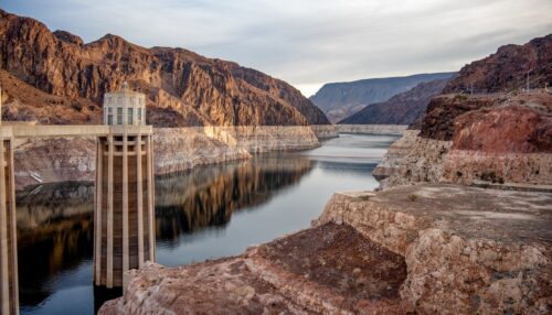
“In a recent blog post, senior fellow Brian Gray described the new 2027–28 operating guidelines for the Colorado River. These guidelines require significant reductions in water deliveries to the three Lower Basin states—Arizona, Nevada, and California—over the next two years. An accompanying 10-year decision framework could require even larger reductions. But it turns out that the Lower Basin states have another card they can play to preserve their water supply; Gray explains below. Q: How will the new guidelines affect the Upper Basin states of Wyoming, Colorado, Utah, and New Mexico? A: In contrast to the significant reductions in deliveries to the Lower Basin, the guidelines do not require any limitations on Upper Basin water use or recommend specific conservation measures there. … ” Read more from the PPIC.
Officials navigate Colorado River cuts and their impacts on Pinal
““The news is not good but we didn’t expect good news.” It was put that succinctly by the director of the University of Arizona’s Water Resources Research Center, Sharon Megdal, in a video on July 31, the day the federal government announced the terms of the cuts Arizona, and two other states, would take to mitigate a dwindling Colorado River. The basic facts have been widely known for years, even for the majority of Southwesterners who do not monitor reservoir levels daily or study the historic relationship between drought and water availability. Those facts are these: The Colorado River is at historic lows. The main reservoirs fed by the river, Lake Powell and Lake Mead, are prime examples. Persistent drought, since 2000, is the main cause of this. And despite many interstate, and international, plans to mitigate the effects of lower water availability, levels have continued to fall. Negotiations on agreements between the Lower Basin States — Arizona, California and Nevada — and the Upper Basin States — Colorado, New Mexico, Utah and Wyoming — have stalled for years, forcing the federal government, through the Interior Department, to corral the seven states into a 10-year mitigation agreement. This was the predicted result as agreements are due to expire at the end of 2026, and the reality of it is here. … ” Read more from Pinal Central.
Building the foundation: ADWR’s Field Services team spans the state for data on Arizona’s water supplies
“For an agency with a big public profile like ADWR, public outreach is an important part of the job description for many of the Department’s team members, and very often that means doing presentations. We do presentations on Colorado River conditions, groundwater supplies and many other water-related subjects for neighborhood organizations, lawmakers, civic groups and others throughout the state. We do lots of informational presentations. And, sometimes, we do them for our own team members. Earlier in October, ADWR’s Statewide Monitoring Team, also known as our Field Services Section, conducted a seminar for ADWR employees on the team’s wide variety of duties, much of which occurs in the farthest reaches of rural Arizona. … ” Read more from the Arizona Department of Water Resources.
Why Arizona is now a hotspot for data center construction, and what residents want to change
“The Phoenix area is experiencing a data center construction boom, transforming vacant lots and former farmland to meet digital demand in Arizona and beyond. Data centers keep the digital world running around the clock — streaming TV, cloud storage, banking, and artificial intelligence – but these facilities also require substantial power and water, which impact surrounding communities. DataCenterMap.com tracks locations worldwide and ranks Arizona eighth in the U.S. with 160 existing and proposed facilities statewide. Why is Arizona such a draw? “Land is inexpensive in Arizona; they require a lot of land to build,” said Vijay Vittal, a professor at ASU’s School of Electrical, Computer and Energy Engineering. … ” Read more from Channel 15.
Tropical Storm Rachel drenches Southern Nevada but barely boosts Lake Mead levels
“Tropical Storm Rachel sent floodwaters rushing through the Las Vegas Valley over the weekend, but it did not deliver a major boost to Lake Mead’s struggling water supply. Lake Mead remained at 26% capacity, with a water level of 1,037.75 feet above mean sea level. That level was still barely above record lows recorded just days before rain began falling in Southern Nevada. While the storm brought much needed moisture to the region, experts said the impact on Lake Mead is limited. “This storm definitely improves conditions in Lake Mead,” said Jack Schmidt, a senior research scientist with the Utah State University Center for Colorado River Studies. But Schmidt said it is more of a temporary fix than a long-term solution for water shortages across the West. … ” Read more from Channel 3.
In national water news today …
Cities worldwide are sinking
“Parts of Mexico City are sinking by more than 8 inches a year, according to researchers that tracked land movement in hundreds of cities worldwide and found some of the most severe sinking in Asia and Mexico. In their study published Monday in Nature Cities, researchers examined 465 cities across 107 countries using satellite observations collected between 2014 and 2023. They found that sinking ground could threaten buildings, roads and drainage systems while increasing flood risks. The process, known as land subsidence, happens when the ground slowly settles or sinks. It can occur naturally as soil and sediment compact, but human activities, particularly pumping groundwater, can also contribute. “Given the potentially large threat land subsidence poses to urban socio-natural systems, it is imperative to implement effective mitigation and adaptation strategies to minimize its detrimental impacts,” researchers wrote in the study. “Achieving this goal requires a comprehensive understanding of the spatial patterns and evolutionary trends of global urban subsidence.” … ” Read more from the Courthouse News Service.
Scientists reaffirm ‘incontrovertible’ evidence of human influence on climate
“The scientific evidence for human-caused global warming is stronger than ever, according to a major new review – despite a United States government report questioning the science. The study shows that more than three decades of climate “fingerprint” research has provided overwhelming evidence that greenhouse gas emissions are driving changes throughout Earth’s climate system. It argues that the scientific basis for the US Environmental Protection Agency’s landmark 2009 Endangerment Finding – the legal determination that greenhouse gas emissions endanger public health in the US – was already compelling in 2009 and has become even stronger since then. Publishing on Monday 12 October in the journal Earth’s Future, an AGU journal, and led by Prof Benjamin Santer at the University of East Anglia (UEA), the review traces the history of climate fingerprint studies, a field that uses patterns and timing of climate changes to distinguish between human and natural influences on Earth’s climate. The review follows what the scientists call a “deeply flawed” July 2025 report from the US Department of Energy (DOE), which challenged the credibility of climate fingerprinting and questioned the scientific basis for the Endangerment Finding. … ” Read more from the American Geophysical Union.