
Several news sources featured in the Daily Digest may limit the number of articles you can access without a subscription. However, gift articles and open-access links are provided when available. For more open access California water news articles, explore the main page at MavensNotebook.com.
On the calendar today …
- WORKSHOP: Central Valley Flood Protection Board beginning at 9am. The workshop will focus on the Sutter Bypass, and will include B. How the Flood System Operates: A Focused Overview of the Sutter Bypass; State Perspective within the Central Valley Flood Protection Plan; Sutter Bypass Preliminary Technical Results from the 2027 CVFPP Update; and Local Perspectives. Click here to register.
- WEBINAR: The 1877-78 El Niño: A Historical View of Super El Niños in NOAA ERSSTv5 Reconstruction from 9am to 10am. This October, join us for three Friday NOAA Environmental Data (NED) Talks at noon that will take you on a comprehensive journey through the lifecycle of the El Niño Southern Oscillation (ENSO). We’ll start by looking back at historical El Niño events to better understand past patterns and establish a baseline. The 1877–78 El Niño may have been one of the strongest El Niño events on record—potentially even stronger than the major events of 1982–83, 1997–98, and 2015–16. Join Dr. Boyin Huang to learn how a new analysis of NOAA’s Extended Reconstructed Sea Surface Temperature version 5 (ERSSTv5) data is helping scientists better understand this historic event and reduce uncertainty in the historical record. Click here to learn more and register
In California water news today …
El Niño: New forecasts show high chance for California rainfall at 150%-200% of normal this winter
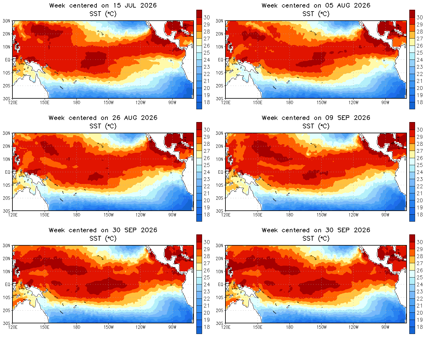 “Like a pot of water on a slow boil, El Niño conditions in the Pacific Ocean are continuing to intensify, scientists said Thursday, setting up a winter that could bring drenching rain to some parts of California — at amounts potentially double the historical average, particularly in January and February. On Thursday, scientists at NOAA, the National Oceanic and Atmospheric Administration, said there is a 100% chance of a strong El Niño being present from now through March, and an 83% probability that it will rank as the strongest in history since modern records began in 1950, up from 69% two months ago. “We are seeing a lot of warmth in the tropical Pacific, which provides ample energy for storm systems as we move through the fall and winter,” said Michael Anderson, state climatologist with the California Department of Water Resources. “Be ready for the storms and watch those forecasts.” … ” Read more from the San Jose Mercury News.
How California is bracing for a winter of floods, fires and extreme storms all at once
“Before this year, the US National Weather Service had never issued a September coastal flood advisory for the San Francisco Bay Area. In the past month, it has had to issue two. As flood water swallowed intersections and eroded beaches up and down the California coast last week, scientists and emergency managers warned that this is just an early signal of a coming tumultuous winter as an already exceptional El Niño continues to strengthen. It’s been called everything from “super” to “Godzilla”, as forecasters hammer home the message that conditions brewing in the Pacific Ocean could soon climb off the charts, and fuel extreme weather around the world. Tens of millions could face food insecurity, and global food prices could be pushed higher. Climate scientists have projected that by February, more than 450,000 people around the world could succumb to spikes in temperature linked to the strong El Niño. Yet more deaths will be caused by floods and droughts, wildfires and rain. … ” Read more from The Guardian.
SEE ALSO:
- California declares state of emergency ahead of historic ‘Super El Niño’: Key implications, from Brownstein
- A Detour from my European Observations: The Clearest Winter Warning from El Niño that California May Ever Get, from Downey Brand
- California gets new rescue gear to fight El Niño flooding threat, from Action News Now
- A historic El Niño is gathering strength. Here’s how to prepare your home, from the San Jose Mercury News
- Ten things to do right now to prepare for predicted severe El Niño impacts, from UC ANR
The ‘Kelvin wave’ hitting California is a potent warning about sea-level rise
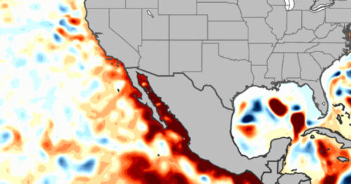
“A slow-moving surge of water called a Kelvin wave is arriving in southern California and looks to be about as large as these waves can get. Though it’s not like the wall of water from a tsunami, the pulse is expected to cause record-breaking sea levels and coastal flooding across the state. It’s also potentially a preview of what California’s sea levels will look like decades from now because of climate change, says Daniel Swain, a climate scientist at University of California Agriculture and Natural Resources. “What we’ll see at the worst this winter will be something that is closer to the norm later this century in terms of sea level,” he says. … ” Read more from Scientific American.
Subsidence from groundwater overdraft risks choking off a vital water artery for Central and Southern California
“One of the major rationales for building California’s two biggest surface water supply projects was to provide a supplemental source of water from Northern California so San Joaquin Valley farmers could reduce their reliance on groundwater. The imported water, it was hoped, would lessen reliance on local groundwater and slow or even halt land subsidence caused by excessive pumping from the aquifers. The idea didn’t work as planned. Today, subsidence and the resulting damage to water infrastructure along California’s State Water Project (SWP) and its sister, the federally run Central Valley Project (CVP), is widespread throughout the San Joaquin Valley, complicating efforts to keep water flowing. … ” Read more from Western Water.
The rising cost of water
“As Americans grapple with a widespread affordability crisis, it seems even water is not immune to economic pressures — in fact, it’s getting more expensive more quickly than other basic needs. A new report finds that over the past 10 years, the cost of household drinking water increased faster than the cost of groceries, faster than inflation and faster than household income. The report was produced by Food and Water Watch, an advocacy organization that campaigns for clean water, increased food access and other environmental causes. On average, the cost of drinking water increased 62 percent — but this number blurs enormous state-by-state variations. It went down 2 percent in Shreveport, La., between 2015 and 2025 and increased more than 300 percent for customers of Oregon’s Tualatin Valley Water District. … ” Read more from Governing.
Western droughts are more connected than scientists thought, study finds
“Droughts and wet periods in major Western watersheds often happen together, according to new research that shows how water conditions in one area can be closely tied to those hundreds of miles away. Researchers analyzed more than 20 years of satellite and climate data from five major areas: the Upper and Lower Colorado River basins, the Great Basin, California and the Pacific Northwest, including parts of Mexico and Canada. Together, those areas provide water to more than 60 million people and vast stretches of farmland. The researchers found some of the strongest connections between California and the Great Basin — which includes most of Nevada and much of Utah. Runoff conditions in the two areas were synchronized 65% of the time, while soil moisture moved together 67% of the time. … ” Read more from KUNR.
Delta Science Program seeks input on water projects’ effects on fish
“At the request of the U.S. Bureau of Reclamation, the Delta Science Program is facilitating an independent scientific peer review of new lines of evidence for effects on fish from the long-term operations of the Central Valley Project and State Water Project, and the resulting impacts on the fish. Interested parties can submit no more than two pages of input relevant to the charge questions by Oct. 16 via email to reviewadvice@deltacouncil.ca.gov or mail to Delta Science Program (Peer Review Unit), 715 P Street, 15-300, Sacramento, CA, 95814. Input deemed relevant by the Delta lead scientist will be provided to the independent panel of experts as supplemental review material and posted on the peer review’s web page. It may also inform the panel’s final report, expected in December 2026, at the panel’s discretion. … ” Read more from The Press.
Prop 45 explained: CEQA overhaul could shift who holds power over building
“In 2014, residents and environmental groups argued in a lawsuit that a California Department of Transportation road project planned to run through Richardson Grove State Park failed to properly evaluate how it could harm the redwood trees. It still took courts a total of 15 years to resolve all of the related legal complaints before Caltrans could move forward with building. Environmental advocates say the litigation led to changes that better protect redwood trees. But pro-building advocates point to the case as evidence that the California Environmental Quality Act and the review process it requires need an overhaul. Proposition 45 , a November ballot initiative that aims to streamline the process, would change how fights like this one play out. … ” Read more from Cal Matters.
The final act: California’s end-of-session and gubernatorial actions wrap-up
“As the 2025-26 legislative session came to a close and as his final term approaches the end, California Gov. Gavin Newsom ceremonially signed the last bill of the 2025-26 regular session from atop the Golden Gate Bridge on Sept. 30. The measure, SB 895 (Wiener), places a $7.5 billion science and health research bond before California voters. In total, the governor acted on 1,160 measures this legislative year, signing 1,040 bills and vetoing 120, before the conclusion of one of the final major legislative sessions of his administration. This client alert provides an overview of key gubernatorial actions affecting several policy areas that are expected to shape California’s regulatory and economic landscape in the years ahead. The legislation highlighted below includes significant measures related to climate and natural resources, housing, data centers, artificial intelligence (AI) and film production. Together, these actions signal emerging trends that will likely remain at the forefront of legislative, regulatory and business discussions as California moves into 2027 with a new governor and a new class of legislators. … ” Read more from Brownstein.
In commentary today …
Hydropower keeps California moving — policy needs to catch up
Bruce McLaughlin, general manager of the Power and Water Resources Pooling Authority (PWRPA), writes, “The very water system both you and I rely on, whether in your home, running a small business, or working on land that’s been in your family for generations, is the same system that stores water, moves it across the state and uses that movement to generate clean, affordable electricity in return. We have hydropower systems to thank for that. Hydropower plays a critical role in maintaining both affordable, reliable electricity, and water flow and distribution. That built-in, reliable cycle keeps electricity costs down. It’s the kind of reliability families and businesses depend on, especially as utility bills keep rising. And yet, that affordable reliability remains threatened. Why? A challenge that exists at the state level is that policies shaping California’s energy future haven’t fully caught up. Large hydropower, one of the state’s most reliable sources of clean energy, still falls outside key definitions in the Renewable Portfolio Standard — the state’s primary clean energy program, which requires utilities to procure renewable electricity to meet California’s energy goals. However, not all hydropower resources count toward those targets. … ” Read more from Capitol Weekly.
In regional water news and commentary today …
NORTH COAST
Why scientists are removing trout from Klamath mountain lakes
“California scientists are removing nonnative trout from selected high-elevation lakes in the Klamath Mountains to restore habitat for native frogs and salamanders. The lakes were historically fishless before trout were introduced for recreational fishing. Removing those predators could help species such as the Cascades frog and long-toed salamander recover. Justin Garwood, an environmental scientist with the California Department of Fish and Wildlife, said introduced trout transformed the lakes into ecosystems dominated by fish predators. “Currently we use mechanical methods,” Garwood said. “We capture fish with gill nets to remove them.” … ” Read more from Jefferson Public Radio.
Organizers plan events to rally for Klamath, Trinity river protections
“Tribal organizers and river‑advocacy groups are calling on North Coast residents to show up this weekend for a salmon dinner and later this month as the State Water Resources Control Board prepares to vote on the Bay Delta Plan and Gov. Gavin Newsom’s voluntary agreements, a decision they say could weaken protections for the Trinity and Klamath rivers at a critical moment. Community events planned in Hoopa and Arcata are building toward the Oct. 29 State Water Board hearing in Sacramento, where organizers expect a noon rally and public comment. The push, led by Communities United for Water Protection and local communities, follows Gov. Gavin Newsom’s veto of two tribal rights and environmental bills that organizers say underscore the need for stronger river protections. “For the last 20‑plus years, the tribes on the Klamath and Trinity have led efforts to restore flows to the river,” said Regina Chichizola of Communities United for Water Protection. “We’re really hoping the community can come out and tell the state that it’s critical they protect these Trinity River flows and the flows that stop Klamath fish kills.” … ” Read more from the Eureka Times-Standard.
SIERRA NEVADA
Sugar Pine Foundation to replant Caldor Fire scar with support from Tahoe Community Foundation
“The Sugar Pine Foundation (SPF) has been awarded a $22,000 Community Impact Grant from the Tahoe Community Foundation to continue reforesting the Caldor Fire burn scar near South Lake Tahoe. The funding will support the planting of 5,000 native conifer seedlings across approximately 50 acres over the next year, with work concentrated at three priority locations: Fountain Place Road, Hell Hole Road, and Echo Summit. For many South Lake Tahoe residents, the Caldor Fire is still a vivid memory: the smoke, the evacuations, and the eerie aftermath of a landscape transformed almost overnight. Nearly five years later, the burn scar is in active recovery. Hazard trees along roads and trails have been cut, piled, and removed by logging contractors, and in steeper areas hand crews have piled the dead trees to be burned. Some areas are recovering naturally with a carpet of young seedlings, but many hillsides are filling in with dense, flammable brush (ceanothus, manzanita, and chinquapin) rather than recovering as forest. These areas may not in our lifetime return to the open, shaded woodland that hikers, mountain bikers, and neighbors knew before the fire. … ” Read more from the Tahoe Daily Tribune.
SACRAMENTO VALLEY
Commentary: Everyone hates data centers. Sacramento has good reasons to welcome them
Opinion writer Tom Philp writes, “Data centers have the public appeal of a communicable disease right now. They are opposed by 70% of Americans according to a recent Gallup poll. These facilities—which house computer systems, servers, storage drives and other equipment to power artificial intelligence—are big water guzzlers sparking protests across California and America. But what if I told you it makes all the sense in the world to locate data centers here in Sacramento. In fact, it’s surprising that there aren’t more data centers in Sacramento already. Thanks to the Sacramento Municipal Utility District, Sacramento has some of the cheapest electricity in California. And thanks to city forefathers, Sacramento has laid claim to more water than these centers could ever use. In fact, Sacramento could risk losing water rights it has long claimed. Using more water is the tried-and-true way to preserve those rights. … ” Read more from the Sacramento Bee.
NAPA/SONOMA
Ambitious Esmeralda development edges closer to reality, but Cloverdale council slows pace
“The ambitious Esmeralda development slated for the site of an abandoned sawmill in Cloverdale, is edging closer to a vote that could give it approval. But residents will likely have to wait until November to see if that happens, councilmembers agreed at the conclusion of a marathon special meeting Wednesday night, Oct. 7, at the Cloverdale Veterans Memorial Building. “We need more time on this. I need more time on this,” Mayor Brian Wheeler said following five and a half hours of presentations, questions and public comment. “It’s a lot of information.” Indeed, the draft entitlements package for the housing, retail and restaurant project, which the city recently posted to its website, run thousands of pages. The latest environmental impact report addendum alone is 348 pages; its eight appendices total another 1,009. And there are numerous documents beyond that, including draft general plan amendments, specific plan and development agreement, and a final economic impact analysis. … ” Read more from the Santa Rosa Press Democrat.
BAY AREA
Dangerous surf, high tides and coastal flooding forecast for Bay Area this weekend
“A trip to the beach this weekend could be a lot more dangerous than it looks. The National Weather Service issued a Beach Hazards Statement Thursday for the San Francisco Peninsula coast and coastal North Bay, warning of breaking waves up to 16 feet, sneaker waves and strong rip currents from Saturday morning through Monday afternoon. At the same time, a Coastal Flood Advisory is in effect from Friday morning through Tuesday afternoon for San Francisco, Monterey Bay and other bayshore areas. The weather service says up to 1.2 feet of water could cover low-lying areas near shorelines and tidal waterways, with flooding possible at some parks, parking lots, roads and coastal trails. The combination is unusual enough to warrant extra caution from officials. “Never turn your back on the ocean,” the weather service warned. … ” Read more from the San Francisco Chronicle.
Novato gas station contamination lawsuit ends
“A years-old lawsuit filed by a Novato developer against the U.S. Navy over a former gas station site in Hamilton has been dismissed after both parties filed to end the case. Hamilton Square LLC purchased the 2.7-acre property at 970 C St. from the Navy in 2005. The land at the northwest corner of Main Gate Road housed a gas station from the mid-1970s until 1995. Underground gasoline storage leached petroleum-based contaminants into the soil and groundwater in the area, according to the city. The Navy cleaned up the site before the sale and deemed it safe for commercial and industrial development, with certain covenants in place restricting use and requiring additional cleanup if residential development was planned. … ” Read more from the Marin Independent Journal.
Data center moratorium approved by Oakland amid AI backlash
“Oakland has joined several other Bay Area cities in hitting pause on data centers. The City Council on Tuesday unanimously approved a 45-day moratorium on approvals for new data centers. The moratorium can be extended by the council. Councilmember Carroll Fife, who authored the moratorium, has said the goal is to give Oakland time to study the impacts of data centers and make any needed changes to the city’s planning and building codes to protect residents’ health, safety and welfare. People across the country have become skeptical of data centers as tech companies, especially those developing artificial intelligence, have moved fast in recent years to build massive computing warehouses in cities and rural areas. Because data centers consume large amounts of water and electricity, generate noise and take up huge swaths of land, many communities have opposed their construction. …, ” Read more from the Oaklandside.
Santa Clara, California’s capital of data centers, weighs more regulations
“As controversy over data centers swells in communities around the Bay Area and the nation, Santa Clara leaders are pushing to beef up the city’s regulations and standards for future data center development. In an hourslong and at times tense discussion that began Tuesday night and stretched to nearly 1 a.m. Wednesday, the Santa Clara City Council directed city staff to prioritize tightening air pollution and water use regulations for new data centers in the city as they take a more comprehensive look at all city policies related to data centers. The midsize Silicon Valley city of 130,000 people has quietly become the data center capital of California, in large part thanks to its own electric utility, Silicon Valley Power, which sells watts at much lower prices than PG&E. … ” Read more from KQED.
SAN JOAQUIN VALLEY
Keeping the mission flowing: USACE tackles decades-old infrastructure at DLA San Joaquin
“Wipes, a blue latex glove and a torn piece of a magazine are among the debris caught by screens inside a temporary wastewater treatment system at Defense Logistics Agency Distribution San Joaquin in Tracy. “It’s not something most people get to see, but it’s part of the daily work required to keep the installation’s wastewater treatment system running,” said Sacramento District senior project engineer Cynthia Baksys. The Sacramento District is managing a $9.7 million project to rehabilitate the aging wastewater treatment plant. The district awarded the construction contract to G.S.E. Construction Company Inc. in July 2025. The work includes replacing aging mechanical equipment, repairing treatment structures, upgrading electrical systems and replacing pumps and piping of the 1940s era facility. But before crews could begin much of that work, they needed a way to keep treating the installation’s wastewater. That meant bringing in a temporary wastewater treatment system, housed in trailers, to handle the installation’s sewage while the existing plant is out of service. … ” Read more from the Army Corps of Engineers.
Fresno has twice the gravel it needs. A split commission still couldn’t decide on San Joaquin River blast mine
“CEMEX’s proposed blast mine on the San Joaquin River stalled before the Fresno County Planning Commission on Thursday, when commissioners deadlocked 3-3 — a split that amounts to a preliminary denial and sets up a likely appeal to the Board of Supervisors at a date yet to be determined. Fresno County’s meeting hall was packed to the gills Thursday morning: the hearing room was standing-room-only, with three overflow rooms filled with scores of residents from across the county who oppose the controversial proposal, which sits about 200 yards from the San Joaquin River. Speaker after speaker said they could not imagine a worse location for a mine than a river, inside a public parkway, near where salmon spawn and children play at summer camp. “How this is even a project is beyond comprehension,” said one mother, shaking her head as she stared at the ground. “I am sick and tired of Fresno being the butt of every joke. We need to prove them wrong” she said. … ” Read more from Fresnoland.
SOUTHERN CALIFORNIA
After October heat wave, Southern California braces for rain, flooding and high surf
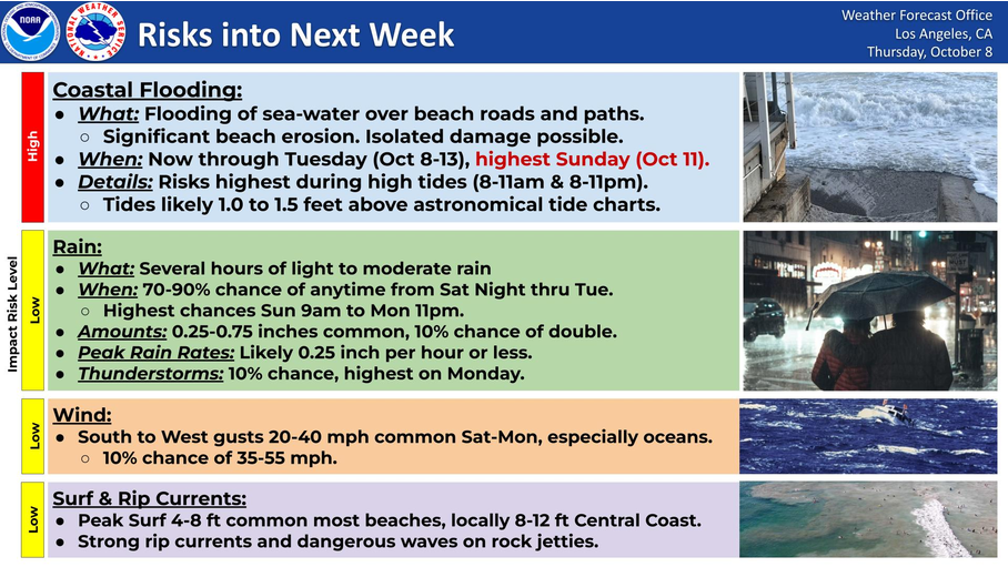 “Southern California is expected to get a reprieve from its prolonged October heat wave this weekend, but the cooldown will come with widespread rain, the possibility of flash flooding in mountain communities and another round of powerful surf threatening an already battered coastline. Moisture associated with Rachel, a tropical storm expected to weaken as it approaches northern Baja California, could bring moderate to occasionally heavy rainfall beginning late Saturday, Oct. 10, with showers potentially lingering through Tuesday, according to the National Weather Service. Although the storm’s center is most likely to remain south of Southern California, forecasters said its moisture, combined with approaching low-pressure systems, could bring rain, gusty winds and significantly cooler temperatures across the region. “The storm system right now is more likely than not to track south of the region,” said Kyle Wheeler, a meteorologist with the National Weather Service in San Diego. … ” Read more from the OC Register.
SEE ALSO: What to know about Hurricane Rachel’s impact on Southern California, from the Desert Sun
L.A. Planning Commission approves water plant overhaul in Atwater Village
“The Los Angeles City Planning Commission has approved an overhaul of a water reclamation facility will bring new open space to the west bank of the Los Angeles River. The project from the City of Los Angeles, planned at 4590–4610 and 4700 West Colorado Boulevard, is a modernization of the Los Angeles-Glendale Water Reclamation Plant. Plans call for demolishing an existing chlorine detention pond to make way for the construction of new wastewater treatment tanks, a personnel building, and a water purification demonstration facility among other improvements. … ” Read more from Urbanize LA.
World’s largest wildlife crossing is on track to open this winter — unless El Niño intervenes
“The world’s largest wildlife crossing over the 101 Freeway in Agoura Hills is barreling toward a Dec. 2 completion date. Perhaps the only thing that could stop it is a fierce winter storm. Already, a concrete bridge stretches across 10 lanes of whizzing traffic. Atop that, there’s a lush landscape sewn with 6,000 native plants. Recently, crews completed another overpass over adjacent Agoura Road. A big remaining to-do is to fill in the gap between the freeway and the road — and the freeway to the land to the north — with millions of cubic feet of soil to create a seamless pathway for animals. The idea behind the Wallis Annenberg Wildlife Crossing is to provide a lifeline for mountain lions in the Santa Monica Mountains, locked in by traffic and suffering from the effects of inbreeding. … ” Read more from the LA Times.
Volunteers work to remove invasive plants in the Pacific Palisades before El Niño-driven rains
“Jordan Corral had to do something. It was late 2024, during a historically dry start to the winter. But the winter before that had been historically wet. This kind of “weather whiplash” is growing more common with a warming climate, research is finding. And it meant the hillsides of the Santa Monica Mountains were overgrown with invasive and highly flammable plants, such as black mustard, castor bean and fennel. So Corral got to work. Alongside mentor Bill Neill, the president of the Santa Monica Mountains chapter of the California Native Plant Society, Corral pulled together a group of volunteers to pull out invasive plants. … ” Read more from the LAist.
Coastkeeper demands OC supervisors allow public access to creeks and waterways
“This week, we sent a letter to the OC Board of Supervisors demanding that they open up Orange County’s waterways to the public. Our creeks and streams have some of the most restrictive access laws in California, so much so that they violate our state’s constitution. In most other counties, such as Riverside and San Bernardino, people can freely recreate in their waterways. We envision a future where families can freely fish in Trabuco Creek, birdwatch in San Diego Creek, wade in the Santa Ana River, and everything in between. Creeks and waterways belong to the public, not the government. We’ve called upon the Board of Supervisors to repeal their illegal ordinance and remove the “No Trespassing” signs seen all over our waterways. If they don’t comply, OC Coastkeeper intends to file a lawsuit to enforce our Constitutional rights as Californians. … ” Read more from the OC Coastkeeper.
Milestone event centers water in the San Gorgonio Pass area’s economic future
“Sixty-five years after its founding, San Gorgonio Pass Water Agency (SGPWA) brought 220 people together Tuesday for its landmark State of the Pass event at Morongo Casino Resort & Spa. New research from Beacon Economics quantified what decades of investment in reliable water have made possible, and what it will take to secure the Pass area’s water and economic future. Roughly one in four gallons used in the Pass area today depends on engineered supplies, meaning water that is imported, stored, recycled or captured through deliberate investments in water reliability. By 2050, that figure is projected to approach one in two. Every acre-foot of water used in the region supports about $243,000 in annual economic activity. “Water gives the Pass area choices,” said SGPWA Board President Robert Ybarra. “It gives our cities the ability to pursue housing, jobs and economic opportunities based on what is right for their communities, rather than having their future dictated by water scarcity. When water is reliable, communities can make decisions based on opportunity instead of limitation.” … ” Read more from the San Gorgonio Pass Water Agency.
The 66-mile Calif. mountain highway above LA only opens once every few years
“Last August, the full length of Angeles Crest Highway reopened for the first time in years, allowing hikers, campers, classic car drivers and others full access to the east-west road that cuts through the center of Angeles National Forest. When not closed for repairs, the famous mountain road takes travelers from just north of Los Angeles all the way out to the Cajon Pass, which connects California’s high desert with the Inland Empire below. It took years for Caltrans to repair damage from the “relentless storms” in the winter of 2022-2023, which collapsed parts of the roadway and caused rockslides, according to Caltrans. But Angelenos didn’t have much time to enjoy the entire expanse of the national forest’s more than 700,000 acres, much of which is connected directly to the troubled road. Just a few months later, another winter storm rolled in, and a large chunk in the middle of the 66-mile mountain highway closed again. “ANGELES CREST HIGHWAY IS DESTROYED,” wrote one Los Angeles County Sheriff’s Department official on Instagram at the time. … ” Read more from SF Gate.
IMPERIAL/COACHELLA VALLEYS
Desert Water Agency customers to see rate changes in 2027; how much could bills increase?
“Water bills are going up for Desert Water Agency customers starting January 1, 2027, and some Coachella Valley residents are already raising concerns about what another increase could mean for their household budgets. The agency says the upcoming rate adjustments will result in an average 6.25% increase, with the additional revenue helping cover aging infrastructure, rising operational expenses and improvements to the region’s water system. But for some residents, the question isn’t just how much more they’ll pay. It’s why their bills keep increasing. “I’d like to know why. And I’d like to understand why the service charge is so hard, is so high. It just. It doesn’t make sense to me as a consumer,” said Kenneth Morris, a local resident. … ” Read more from KESQ.
USDA pours $25 billion into rural America; Imperial County positioned for housing, water and business investments
“The U.S. Department of Agriculture is investing nearly $25 billion in rural communities nationwide, with California receiving more than $615 million in loans and grants in fiscal year 2026—including a substantial regional investment covering Imperial, Riverside, and San Bernardino counties, according to a recent USDA press release. The announcement comes as Imperial County faces many of the challenges USDA Rural Development programs are designed to address: a shortage of affordable housing, aging infrastructure, water-system needs, limited economic opportunities and the continuing need for reliable broadband in rural communities. Nationwide, USDA Rural Development invested nearly $25 billion during fiscal year 2026, according to the department’s Oct. 6 announcement. The money went toward housing, water and wastewater systems, electric infrastructure, broadband, businesses, health care, emergency services and other community facilities. … ” Read more from the Desert Review.
Mexicali Valley faces impending crisis following allotment cuts
“Farmers in the Mexicali Valley face a deepening water crisis that threatens to derail winter crops early next year following a double hit of international cutbacks and federal reallocations, regional agricultural leaders warned. Rubén Camacho Ledón, president of the Permanent Agrarian Congress (CAP), said local growers will bear the brunt of reduced flows from the Colorado River under Minute 334 of the International Boundary and Water Commission (IBWC/CILA). Under the agreement, Mexico is ceding 308 million cubic meters (308 million m3) of its annual Colorado River quota during 2027 and 2028 due to a 25-year drought across the river basin, La Voz newspaper reported. … ” Read more from the Imperial Valley Press.
SAN DIEGO
Answers begin to emerge about Chollas Creek chemical contamination at San Diego town hall
“Last month, inewsource reported on a decadeslong toxic chemical contamination at Market Creek Plaza in the Chollas Creek community of San Diego. Soon after, we reached out to elected officials with questions. Though most left our questions unanswered, some wrote back with statements expressing concern. U.S. Rep. Juan Vargas wrote a letter to the U.S. Environmental Protection Agency, calling on the agency to help mitigation efforts. At the time, state Sen. Akilah Weber Pierson’s office did not respond to our inquiry. But on Thursday, the senator paid a visit to the community and hosted a town hall at Lincoln High School with state officials and a Market Creek Plaza representative. … ” Read more from iNewsSource.
Along the Colorado River …
Rachel to break Southwest heat and ease drought, but with flood risk
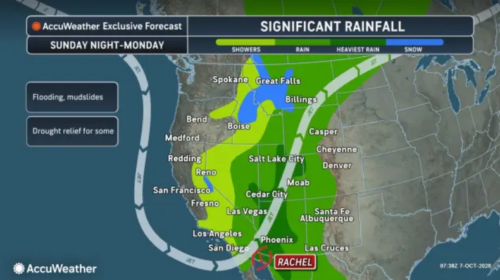 “Hurricane Rachel is expected to eventually turn toward Mexico and send heavy rain into parts of the southwestern United States, raising concerns about renewed flooding after September’s downpours. Rachel, when combined with a non-tropical storm, could help prime the Colorado River, should drenching rain reach the basin as forecast. As of Tuesday afternoon, Rachel was a Category 1 hurricane with maximum sustained winds of 85 mph. Rachel was about 740 miles west of the southern tip of Baja California Sur, Mexico, and was moving west-northwest at 7 mph. “The hurricane is forecast to move away from land initially, keeping its strongest winds and heaviest rain offshore for much of this week,” AccuWeather Lead Hurricane Expert Alex DaSilva said. … ” Read more from AccuWeather.
Water-based philanthropy: A drop in the bucket?
“Amazon wants to help save the Colorado River. That is a good thing. But is it enough? The company has announced a $20 million investment in water-conservation projects across the Colorado River Basin and is helping launch a corporate coalition with a two-year goal of mobilizing $100 million. One Arizona project will invest $2.4 million toward irrigation-efficiency technology on tribal farmland in the Lower Colorado River Basin. Amazon says the project is expected to save approximately 238 million gallons of water each year. Amazon is not alone. Intel says it has funded 20 water-restoration projects benefiting Arizona that, when fully implemented, are expected to restore almost 2.2 billion gallons annually. … ” Read more from In the Center Lane with Herb Paine.
Invasive zebra mussels have made their way to the Utah portion of the Colorado River
“Biologists have discovered a live adult zebra mussel below the Westwater Recreation Area in the Utah side of the Colorado River, raising the risk of the invasive species spreading in the state. The discovery was made Sept. 22, about a month after testing detected zebra mussel DNA in the water in Utah, according to a news release from the Utah Division of Wildlife Resources. The division received confirmation Wednesday that it had in fact found a live mussel downstream of the infestation near Loma, Colorado. Utah’s Division of Wildlife Resources has ramped up testing for zebra mussels in the Colorado River between the state line and Moab after the Loma infestation was detected in 2025. Once an invasive species is detected, concerns of outbreak are elevated as the risk grows of people recreating in the river and then unknowingly transporting organisms to other waterbodies on their watercraft, the division warned. … ” Read more from the Utah News Dispatch.
SEE ALSO: Live zebra mussel confirmed in Utah portions of the Colorado River, from Utah Division of Wildlife Resources
Colorado River tribes still fighting for their rights as feds, states adopt new rules
“The Colorado River stretches 1,450 miles across the U.S. And for just 17 miles, the river flows through the Fort Mojave Indian Tribe’s reservation, which spans across three states: Arizona, California, and Nevada. Fort Mojave Indian Tribe Chairman, Timothy Williams, on a humid triple digit day in the valley shows me around the tribe’s checkerboard farmland in Arizona. That’s the state in which the tribe has the most water rights. “Look over there, multi-million dollar homes that are right there across the river,” Williams said. “And here’s our infrastructure and trying to provide for an entire people.” The tribe has 133,000 acre-feet of water a year – enough to sustain over a quarter of a million households. Most of that goes to their alfalfa and upland cotton operation, which pays for healthcare services, housing, a state of the art elementary school, tribal utilities and other services. But as states, cities, and the federal government fight over the future of the river, all of that is at risk. And tribes like the Fort Mojave are often left out of the negotiations. … ” Read more from Water Education Colorado.
How the QSA improved water conservation, reliability, technology, and infrastructure
“It’s now painfully clear that the Colorado River is a limited resource which has been decreasing in flow for the past 25 years. Therefore new water conservation and transfer initiatives are more critical than ever to the continued economic and social vitality of the Southwest. An excellent example of this was provided in 2003 by the QSA between San Diego and the IID. In 2003 the San Diego County Water Authority (SDCWA) and the Imperial Valley Irrigation District (IID) forged a mutually beneficial water partnership that demonstrated that urban sustainability and agricultural prosperity could thrive together. In their “Quantification Settlement Agreement“, the SDCWA provided major infusions of capital to the IID in exchange for an annual allotment of 200,000 acre feet of Colorado River water, accounting for more than half of the region’s water supply. The SDCWA received an additional 77,700 acre-feet of water that was conserved by lining long stretches of the All-American and Coachella canals. … ” Read more from Coyote Gulch.
Engineering the Arid West: Limits of concrete — Senior rights, market transfers, and the post-2026 reckoning
“Covering canals with solar arrays preserves surface water from the sun, and tightening municipal pipes plugs unseen subterranean losses. Yet no amount of structural efficiency can invent new water when the source itself dries up. Across the Southwest, the Colorado River’s physical plumbing is running against an inflexible ledger. By mid-July 2026, the combined storage of Lake Powell and Lake Mead fell to approximately 12.7 million acre-feet—a volume not seen since Lake Powell first began filling decades ago. With federal operational guidelines expiring at the end of 2026, the U.S. Bureau of Reclamation’s projections require Arizona to cut its Colorado River draw by 16% to 20% through 2028. For Arizona, those percentage reductions carry outsized structural consequences. Under the 1968 federal agreements that authorized construction of the Central Arizona Project, Arizona accepted “junior priority” status behind California in exchange for federal funding to build its 336-mile canal. … ” Read more from the Lake Powell Chronicle.
Deadpool Data Dump: Lake Powell’s terrible, horrible, no good, very bad water year
“Lake Powell, the nation’s second largest reservoir, serves as a sort of barometer of the Colorado River watershed’s overall health. The reservoir and river have been struggling since the great aridification’s grim onset in 2002. While the river continues to flow, barely, the 2026 Water Year, characterized by one of the worst snow droughts on record, nearly finished off the reservoir. But in the end, it was saved from dropping to “de facto deadpool” by heavy rain at the beginning and end of the water year, and by larger-than-normal releases from upstream reservoirs. 4.46 million acre-feet: Total Lake Powell inflow from the Colorado, Dirty Devil, Escalante, and San Juan rivers in water year 2026. That’s the third lowest on record, behind 2002 and 2021. This is in spite of the fact that the 2026 snowpack was far lower than those two years, and melting mountain snowpack provides about 80% of the river’s water. … ” Read more from The Land Desk.
In national water news today …
The hidden cost of farmed fish: Pollution, forced labor and the depletion of wild fish
“As of 2022, more than half of the seafood eaten worldwide was farm-raised rather than caught at sea, a fact that has been praised as evidence that fish farming can meet a growing demand for seafood while slowing the collapse of the oceans. But the unbridled embrace of aquaculture as a sustainable answer to feeding the planet ignores some very real costs. The most popular types of farmed seafood — salmon, shrimp, trout, seabass, seabream — are fed “fishmeal,” a protein-rich powder or pellet made from the very kinds of wild fish that aquaculture is thought to save. In fact, fishmeal is fed to two-thirds of global farmed fish. Before they reach market, some farm-raised salmon eat more than six times their weight in wild-caught fish. With thousands of fish farms worldwide, aquaculture provides millions of people with year-round access to affordable protein. Fish farming is also a crucial source of jobs, especially for women in India. … ” Read more from the LA Times. | Read via Yahoo News.
SEE ALSO: The Dirty Secret Behind the Farmed Fish You Eat, from the New York Times