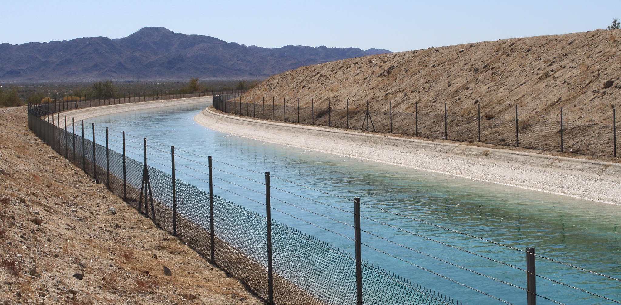
The Colorado River may not be the first river Californians think of, but it is vital to Southern California’s water supply and farms in the state’s southeastern corner. At the California Water Commission’s October meeting, Jessica Neuwerth, executive director of the Colorado River Board of California, outlined the state’s stake in the river, the challenges facing its management, and the decisions that will shape California’s water future.
ABOUT THE COLORADO RIVER BOARD OF CALIFORNIA
Established by statute in 1937, the Colorado River Board of California is a small state agency charged with protecting California’s rights and interests in Colorado River resources.
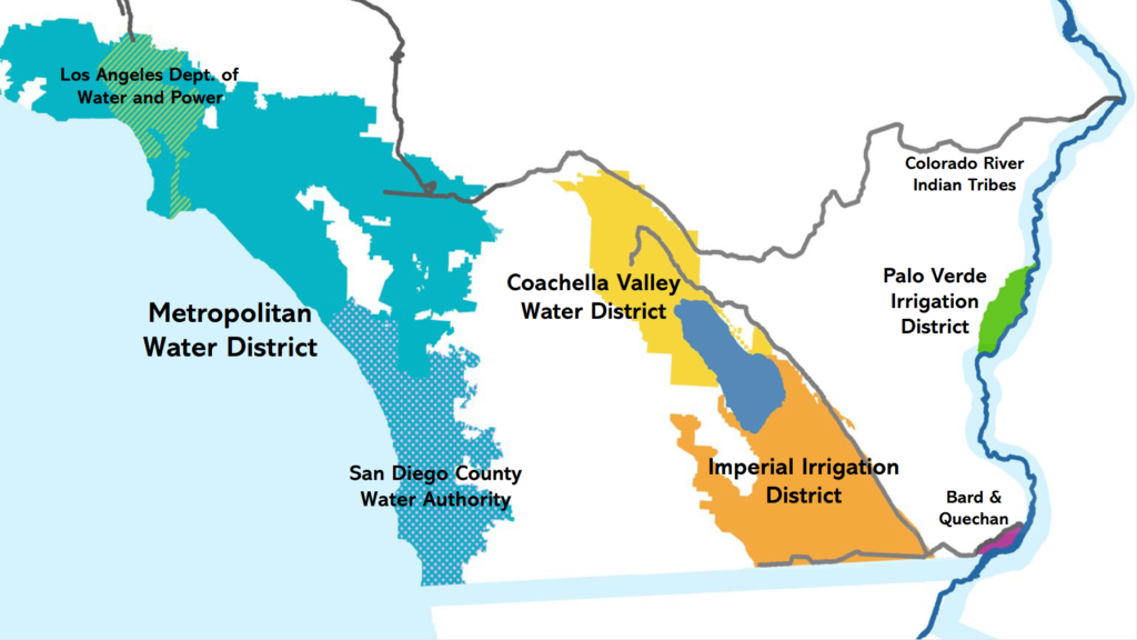
The 10-member board includes representatives from six major Colorado River water and power users in California: Coachella Valley Water District, Imperial Irrigation District, Los Angeles Department of Water and Power, Metropolitan Water District, Palo Verde Irrigation District, and San Diego County Water Authority. Each agency’s governing board nominates a candidate, who is then confirmed and appointed by the governor. The California Department of Fish and Wildlife and the California Department of Water Resources also hold seats, along with two public members.
A central responsibility of the Colorado River Board is representing California in interstate and federal discussions. The board chair serves as the governor’s representative in the Colorado River governance structure, which includes one representative from each basin state. The board and its chair coordinate California’s varied interests and priorities, then represent them in meetings and negotiations with other basin states and the federal government. The current chair is John B. Hamby of the Imperial Irrigation District.
“Most people in California do not really associate the Colorado River with California, but California is the largest recipient of Colorado River water in the entire Colorado River Basin. That water is essential in California, supporting about 25% of urban uses in Southern California, and it serves as the sole water supply for many of our agricultural districts in the interior of California.”
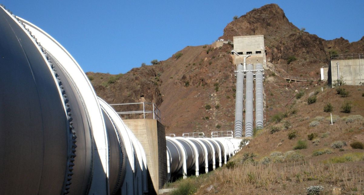
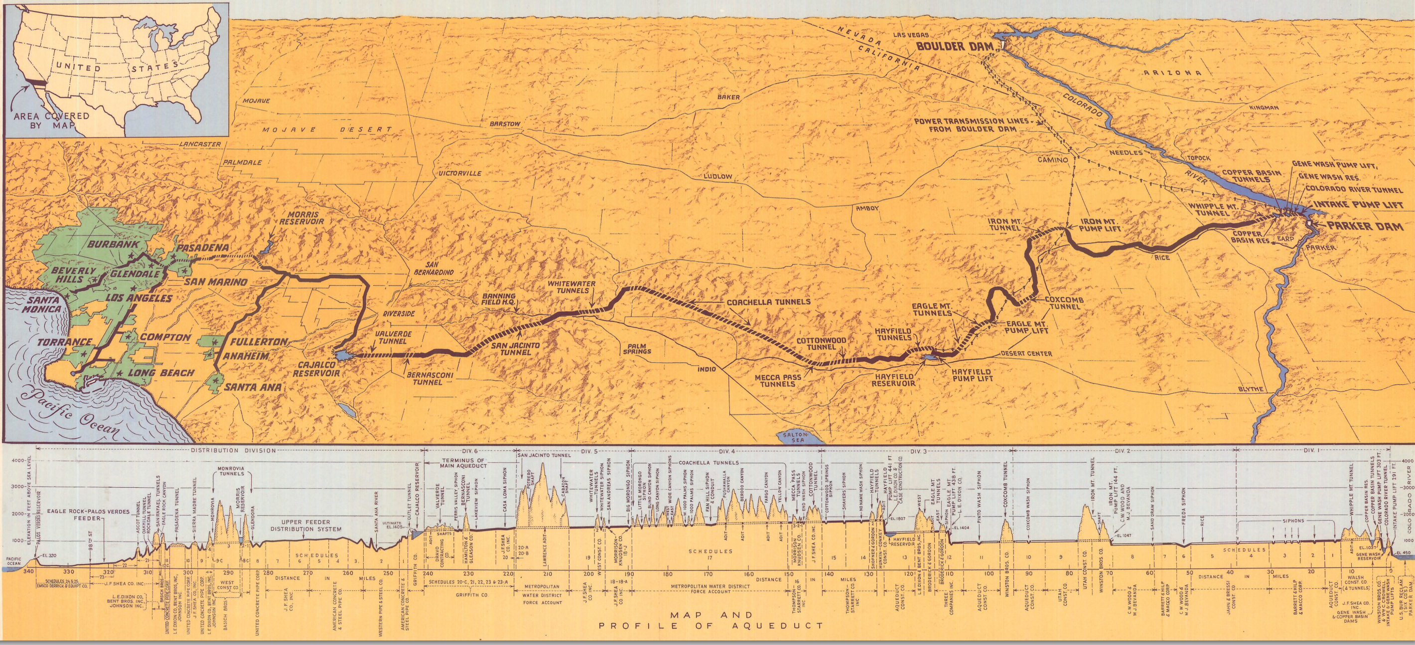
California’s Colorado River water users include several tribes and agricultural districts whose lands border the river. Farther inland, the All-American Canal and Coachella Canal serve the Imperial Irrigation District—the largest irrigation district in the Colorado River Basin—and the Coachella Valley Water District. The Colorado River Aqueduct supplies water to approximately 19 million people in urban Southern California.
Despite its relatively large allocation, California reached the limit of its Colorado River supply comparatively early. For decades, the state used both its basic allocation and surplus water to meet demand. As surplus supplies declined in the late 1990s and early 2000s, California implemented several large-scale intrastate transfers. These arrangements helped establish partnerships among nearly all Colorado River water users in the state.
“We have transfers, conservation programs, and different efforts that link all of these agencies together in something of a web,” Ms. Neuwerth said.
OVERVIEW OF THE COLORADO RIVER SYSTEM
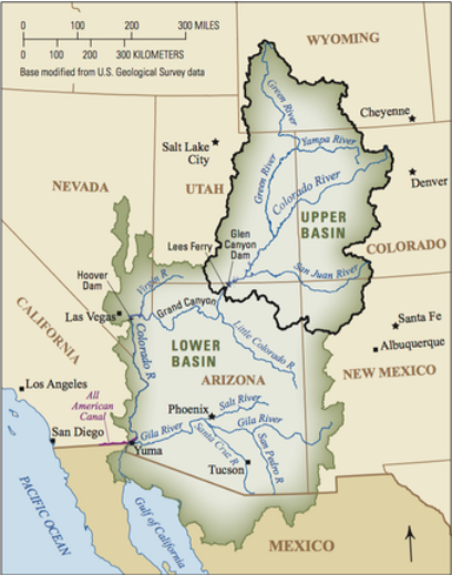
The Colorado River is an international and interstate water system shared by the United States and Mexico. Within the United States, the basin is divided into the Upper Basin—Wyoming, Utah, Colorado, and New Mexico—and the Lower Basin—California, Arizona, and Nevada.
The river is governed by more than a century of legal agreements, including two interstate compacts, a treaty with Mexico, and numerous laws, regulations, and operating rules. Collectively, this framework is known as the Law of the River.
The 1922 Colorado River Compact, one of the nation’s earliest interstate river compacts, forms the foundation of the Law of the River. The compact is approximately three pages long and provides limited detail for addressing the complex questions that have emerged more than a century later, particularly during periods of severe shortage.
Conflicts, contradictions, and unresolved questions within this legal framework can complicate management of the basin, even under typical conditions. These underlying disagreements have contributed to a history of litigation, including Arizona v. California, a Supreme Court case that continued for more than 50 years and established water allocations for the Lower Basin states and tribes along the river’s mainstream.
The Colorado River is a critical resource for the southwestern and western United States. Approximately 40 million people rely on its water, including 30 million in the Lower Basin and 10 million in the Upper Basin. The basin encompasses 30 federally recognized tribes and supports more than 5 million acres of irrigated agriculture.
COLORADO RIVER USE
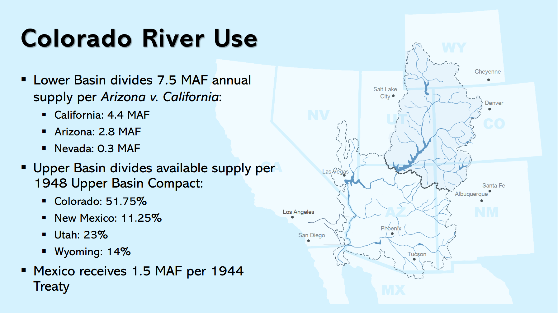 Water use is administered differently in the Lower and Upper basins. In the Lower Basin, the Bureau of Reclamation and the secretary of the Interior exercise substantial control under the legal framework established through Arizona v. California. Reclamation serves as watermaster, maintains detailed records of water use, and administers shortages and surplus supplies among the Lower Basin states.
Under the Supreme Court decree in Arizona v. California, California and the other Lower Basin states share 7.5 million acre-feet of water annually. California’s allocation is 4.4 million acre-feet.
Within California, Palo Verde Irrigation District holds the most senior water rights, which, under the 1931 Seven-Party Agreement, its entitlement is sufficient to irrigate a gross area of 104,500 acres of valley land. The largest share of California’s Colorado River allocation—3.85 million acre-feet—goes to Imperial Irrigation District and Coachella Valley Water District. Metropolitan Water District holds a fourth-priority allocation of 550,000 acre-feet.
The Upper Basin operates under a different administrative structure, with less direct federal control. Each state’s engineer works with water users to determine how water is allocated and used within that state.
The 1948 Upper Colorado River Basin Compact governs relations among the Upper Basin states and establishes how they meet obligations under the 1922 compact. Available Upper Basin water is divided by percentage, with Colorado receiving the largest share at approximately 52%. Mexico receives 1.5 million acre-feet annually under the 1944 treaty.
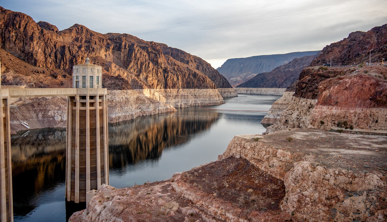
Each basin relies on a major reservoir to support its water-supply operations. Lake Powell, located near the boundary between the Upper and Lower basins, is the principal reservoir for the Upper Basin. Its operations are intended in part to ensure that sufficient water is released to the Lower Basin to maintain compliance with compact obligations.
Lake Mead is the Lower Basin’s principal reservoir and supplies most Lower Basin water users. The Bureau of Reclamation controls its operations.
RISING TEMPERATURE, DECREASING RUNOFF
The Colorado River Basin has experienced substantial aridification over the past several decades. River flows in the 21st century have been approximately 20% lower than in the 20th century, with warming temperatures having an especially pronounced effect during the past seven years.
The 1922 Colorado River Compact is the foundation of Colorado River operations. Developed during an unusually wet period and based on relatively optimistic water-supply projections, it allocated approximately 17.5 million acre-feet annually. The river yielded about 15 million acre-feet per year during the 20th century, and yields have declined significantly in recent years. The basin uses an average of approximately 13.5 million acre-feet annually, while its average yield from 2020 through 2026 was approximately 10.5 million acre-feet.
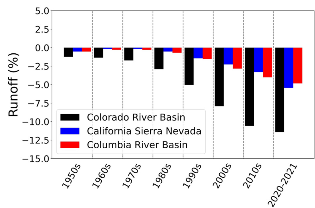
Although aridification and declining runoff are occurring across the West, the effects appear particularly acute in the Colorado River Basin.
“It’s something that we have been actively grappling with, and that has really been exacerbating some of these underlying disagreements,” Ms. Neuwerth said. “There’s just less of this resource to go around, and some of these fights that we had put off for many decades are now no longer avoidable. So, over the past couple of years, with such low runoff—although there has been record-low water use in the Lower Basin over the past five-plus years—even with that, the Colorado River Basin has still been relying on its abundant storage resources to bridge this gap between supply and demand.”
The Colorado River Basin has approximately 60 million acre-feet of aboveground storage, more than four times the river’s annual flow. This capacity has helped the basin withstand significant drought. By 2026, however, much of that stored water had been depleted. Storage remains available, but Lake Powell and Lake Mead are at record-low levels and are expected to continue declining despite substantial reductions in water use across the basin.
These conditions have shaped negotiations among the Colorado River Basin states for several years. Since 2007, the basin has operated under interim rules governing water releases between the Upper and Lower basins and the administration of shortages, particularly in the Lower Basin. Those rules are scheduled to expire in 2026.
NEGOTIATIONS REACH AN IMPASSE
For approximately three years, the basin states worked to negotiate successor guidelines. Many of the proposals included a commitment by the Lower Basin states and Mexico to reduce annual water use by 1.5 million acre-feet. That reduction would address a longstanding structural shortfall in the Lower Basin, but it would not fully resolve the broader water-supply challenges facing the Colorado River Basin.
“We know that there will need to be additional cuts made, and that issue is where the negotiation sort of ground to a halt between the basins,” Ms. Neuwerth said. “The scale of what may be needed in the Colorado River Basin probably is maybe double that one and a half, up to 3 million acre-feet, and maybe more reductions could be needed in any given year, which is a significant reduction from current uses.”
The negotiations divided largely along Upper and Lower Basin positions. The Upper Basin, which uses less water than the Lower Basin, maintains that its states retain the right to develop additional water uses. From this perspective, development should be constrained primarily by local hydrologic conditions rather than mandatory basinwide curtailments or reduction requirements.
The Lower Basin maintains that the Upper Basin has a fundamental obligation to deliver water downstream and holds the junior priority between the two basins. Under this position, the Upper Basin should bear the first reductions or, at minimum, make binding commitments to use less water than it does today.
“This is a really fundamental disagreement between the two basins that we were unable to bridge, despite many, many conversations and a lot of different frameworks and proposals that went back and forth between the two basins,” Ms. Neuwerth said. “So, because of this, we have now reached a point where the Bureau of Reclamation has had to make some decisions.”
POST 2026 OPERATIONS
The Bureau of Reclamation generally prefers the basin states to reach consensus and then implements their joint recommendations. In this case, however, the states were unable to agree. With new operations scheduled to begin October 1, 2026, Reclamation waited until July before releasing its approach.
Reclamation’s approach has two primary components.
Decision framework: The first component is a 10-year decision framework. Rather than prescribing specific operations, it establishes guiding principles, core objectives, and a broad range of operating parameters within which future decisions may be made. For example, the framework allows Lake Powell releases ranging from 5 million to 12 million acre-feet and Lower Basin shortages ranging from zero to 3 million acre-feet.
“So they’ve really just opened the entire spectrum of what operations could be like and analyzed all of those, with the goal that future negotiated solutions would fall somewhere within that framework,” Ms. Neuwerth said. “So these are not intended to be prescriptive. They’re intended to provide a foundation that future negotiated solutions would build from. But it has been sort of confusing, from the basin-state perspective, to figure out, with this broad swath of compliance before them, what the actual operational decisions would look like.”
Operational decisions: Reclamation will make specific operational decisions through separate operating guidelines expected approximately every two years. In August, Reclamation released the first guidelines, covering 2027 and 2028. They incorporate a foundational 1.5 million acre-foot reduction by the Lower Basin and Mexico, additional voluntary compensated conservation, and greater flexibility for Lower Basin water banking in Lake Mead. Water banking has allowed users to store water during periods of lower demand and draw on it during dry years.
“So there are a couple of components in there that were championed by the Lower Basin and that we do support,” Ms. Neuwerth said. “But there are also a couple of stickier issues that Reclamation had to deal with in putting together these operating guidelines for the next two years, and those all relate primarily to Upper Basin operations.”
Lake Powell regulates releases from the Upper Basin to the Lower Basin. In developing the guidelines, Reclamation prioritized maintaining hydropower generation at Lake Powell and reducing infrastructure risks associated with very low reservoir levels. Although this approach protects Lake Powell, it also reduces flows to the Lower Basin and may result in larger shortages there.
The guidelines do not require contributions or reductions from the Upper Basin. “We were not able to reach agreements on that, and so there’s no obligation for the Upper Basin to contribute,” Ms. Neuwerth said. “In fact, the modeling associated with this shows Upper Basin use is growing in the future. So, kind of a mixed bag for the guidelines and what they might mean for water users in the Lower Basin over the next couple of years.”
Litigation followed soon after the guidelines were released. Nevada filed suit in August, and Arizona subsequently moved to intervene. While the litigation remains active, the guidelines continue to govern current releases from Lake Powell and the amount of water available to Lower Basin users in 2027. They provide some clarity for 2027 and 2028, but little direction for operations after 2028.
“I know that there’s a lot of hope that there could be some consensus recommendation from the basin states that might cover post-2028 operations, but there are a lot of challenges with these really deeply entrenched disagreements between the basins on who’s responsible for responding to drought and aridification, and what that looks like,” Ms. Neuwerth said.
WHAT DOES THIS MEAN FOR CALIFORNIA?
California’s share of the 1.5 million acre-foot reduction assigned to the Lower Basin and Mexico is 440,000 acre-feet annually for 2027 and 2028. California negotiated that amount with the other Lower Basin states. The state’s water users must now reach an intrastate agreement on how to collectively meet the reduction and what resources may be available to support it. Those discussions are ongoing.
California has stored water in Lake Mead for approximately 15 years, and water users are considering whether some of those reserves could help meet the state’s required reductions during 2027 and 2028. California is working to complete both its intrastate arrangements and an implementation agreement with the other two Lower Basin states by the end of 2026.
California’s required reductions after 2028 have not been negotiated and remain open-ended. The state therefore has some direction for 2027 and 2028, but considerable uncertainty remains about subsequent operations in both California and the broader basin.
“We’ve had a turbulent couple of years, and we probably have several turbulent years ahead,” Ms. Neuwerth said. “There are many fundamental issues in the Colorado River Basin that we have been able to sidestep for several years, and those issues are now coming to a head. So, understandably, there’s a lot of tension in the basin now as we’re grappling with challenges that are bigger than any we’ve ever seen before.”
“So, I realize I’m leaving on a bit of an uncertain note, but we’re unfortunately in uncertain times.”